Canada 2019: we visited Ontario and Quebec

After our visit to New York City, we set off on our Canadian adventure.

July 23rd

We took the flight from La Guardia airport in New York at 14.00 (more than an hour late) and landed at around 15.30. The airline of choice was Westjet, a low-cost Canadian airline. The airline of choice was Westjet, a low-cost Canadian airline. Except for the delay it was quite a comfortable flight and they even gave us a small snack.

As a first culture shock… the bus shelter at the airport bus stop with a heater. Winter must be a bit harsh.

Toronto

We went straight to a relative’s house to rest a bit before going out for a walk.

In the afternoon, we spent some time strolling around as a first contact with the city. A look at the CN Tower and see the views from the Harbour Front with an iced coffee from Tim Horton’s, a Canadian chain of coffee shops like Starbucks but much cheaper that is all over Canada, in any corner, town or road, there is a Tim Horton’s there.

Harbour Front
Harbour Front

In the evening, on our way back to our accommodation, we went to the Wychwood Pub on St. Claire Ave. for dinner, which was wings night.

They were very, very good and not expensive. The waitress was very funny and we laughed a lot with her. Highly recommended but very far from the centre.

July 24th

We started the day with lots of energy by eating a hearty American breakfast at Sunset Grill on Yonge street, a franchise restaurant serving breakfast all day long.

Sunset Grill

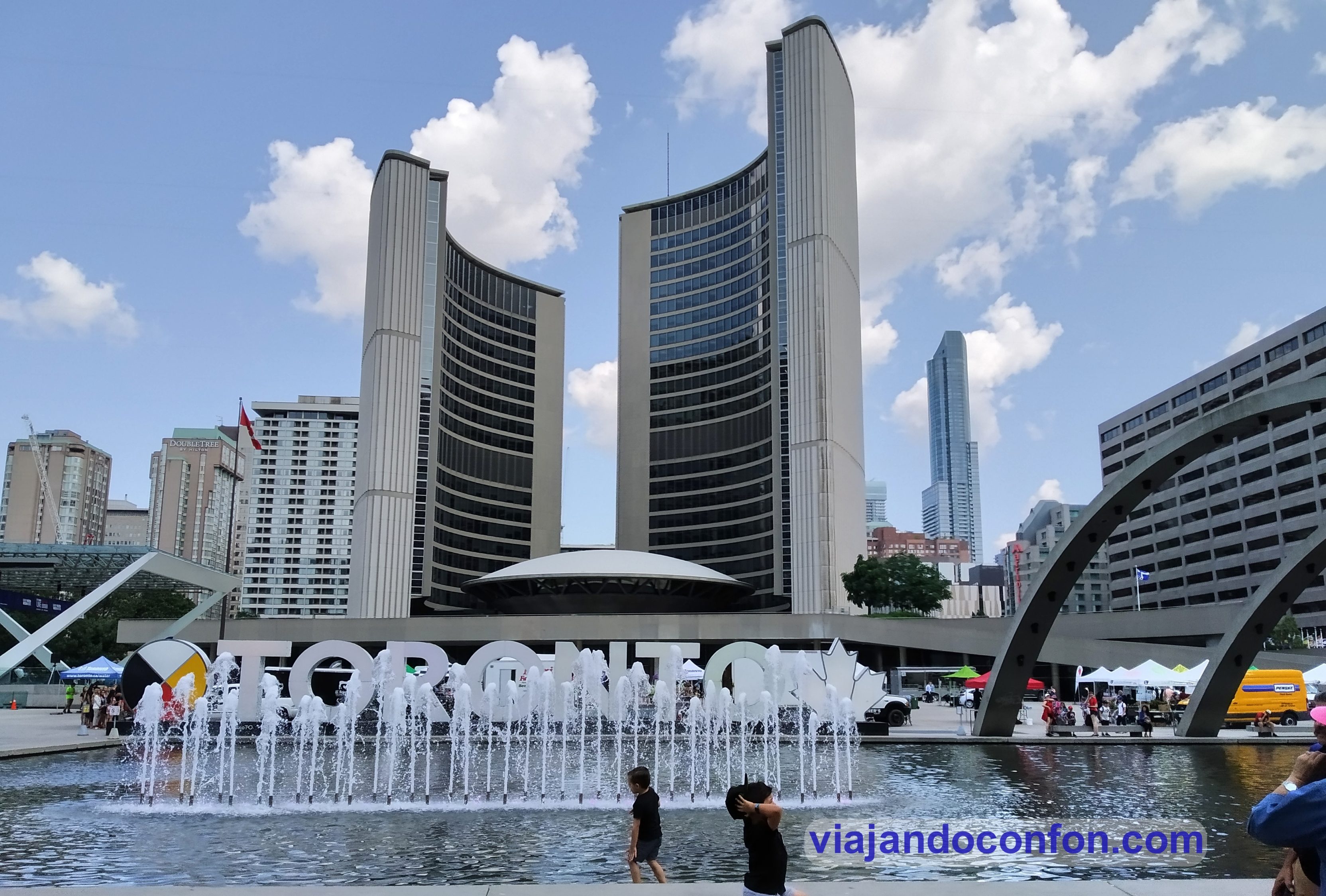
With our stomachs full, we went in search of Nathan Phillips Square, where the city hall and the old city hall stand to one side.

In the square there is the typical giant Toronto sign to take a few photos and behind it the new city hall building. It is a very modernist building where some films have been shot, such as the second part of Resident Evil.

Next to the square is the old city hall building, a more classical construction and, to my taste, much nicer than the new one.

Old City Hall
Old City Hall
City Hall
City Hall

There must have been some kind of beauty pageant or something that day because, all of a sudden, about 50 young girls showed up to have their pictures taken by a professional photographer. Then it was time to retreat.

We took a stroll down to the lakeshore past Toronto’s skyscrapers, Union Station and the Scotia bank Arena to the ferry station to visit the Toronto Islands.

After a twenty minute ride with breathtaking views of the Toronto skyline, we disembark at Centre Island.

The island is set up as a sort of Sunday theme park, where families go to spend the day. There is a small amusement park, a farm with barnyard animals and some restaurants.

Parts of the island were closed as well as some of the surrounding islands because they were flooded. This is due to the very high water level of the lake this year.

Toronto

We took a walk around the island. Some of us got our feet wet in the lake and we rested for a while lying on the grass in the shade. The truth is that in Toronto it was hot in the sun, but in the shade it was very pleasant.

Toronto Islands

At noon we took the boat back to Toronto and went to visit St. Lawrence Market.

It is the main public market in the city and on the upper floor there are many food places where you can get take-away food. You can eat sitting at tables on the terrace.

We chose some roast beef and Montreal smoked loin sandwiches that were to die for.

After a little rest we went to the Distillery District, an old whisky distillery (the largest in the world in 1860), now converted into a tourist area with little shops, cafes and places to have a drink. I’d say it’s a bit too hipster for my taste, but it’s great for a stroll.

Distillery District
what to do in Toronto

On our way back to our accommodation, we stopped for an ice cream at the Dutch Dreams ice cream parlour. It is a Dutch ice cream parlour with spectacular ice cream.

You can choose the type of cone, which they make on the spot, from a wide range of types.

They were spectacular and the small one is so big that it is a perfect substitute for a dinner.

Dutch Dreams Toronto

July 25th

The good stuff begins. Today we start our road trip through Ontario and Quebec. The first thing to do is to pick up the car at the rental office at Toronto airport. We take the direct route to Niagara Falls (123km). A coffee at Tim Horton’s and off we go.

One important note: 4 months after returning, I received a letter from the car rental company informing me that I had been charged for a toll road. It turns out that at some point we passed a stretch of electronic toll road, where there are no turnstiles and, without realising it, they take your number plate when you enter and exit. It was about 17€ (20$) between toll and the company’s management. You have to be careful.

Niagara Falls is a group of three waterfalls at the southern end of the Niagara Gorge, which straddles the border between the province of Ontario in Canada and the state of New York in the United States.

The largest, Horseshoe Falls, also known as Canadian Falls, straddles the international border of the two countries.

The other two, American Falls and Bridal Veil Falls, are within the United States. Bridal Veil Falls is separated from Horseshoe Falls by Goat Island and from American Falls by Luna Island, with both islands located in New York.

Niagara falls

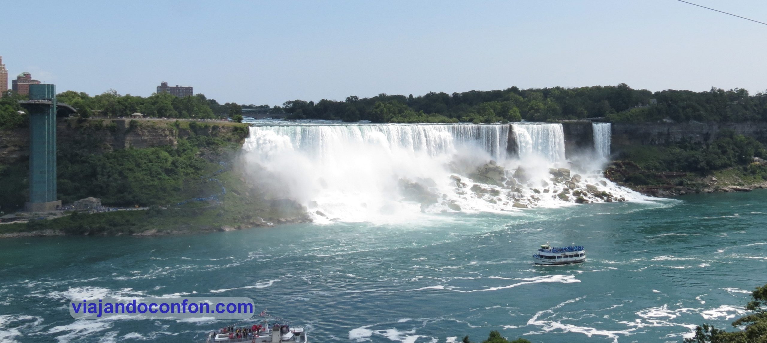
As soon as we arrived we went to the “small” waterfall, which already impressed us. It was spectacular.

We went down to the boat that takes you almost under the falls. There was a long queue but it was quite fast because the boat was big.

When the boat opened, everyone ran to try to get a good spot on the top floor. But it’s better to be on the bottom floor on the left side. It’s not crowded and you have the same view.

They give you a mackintosh before you enter and you still get soaked. If you don’t come out completely wet, you haven’t got a good spot. It’s very, very fun, although it doesn’t last very long.

When we left, we went for a walk along the avenue to the big waterfalls. They are really spectacular, but if you want to take a good picture you almost have to get stuck in the crowd.

niagara falls
Niagara falls day trip
Niagara Falls

We quietly made our way up to the car, ate a small picnic lunch sitting under a tree in the shade and set off again. The destination: Tobermory on the Bruce Peninsula (383km). The accommodation was great, a charming little house in the woods on the shore of Lake Huron.

Tobermory

July 26th

We got up leisurely and had breakfast. We only had to cross the street to get to the small dock where the boat was leaving for Flowerpot Island.

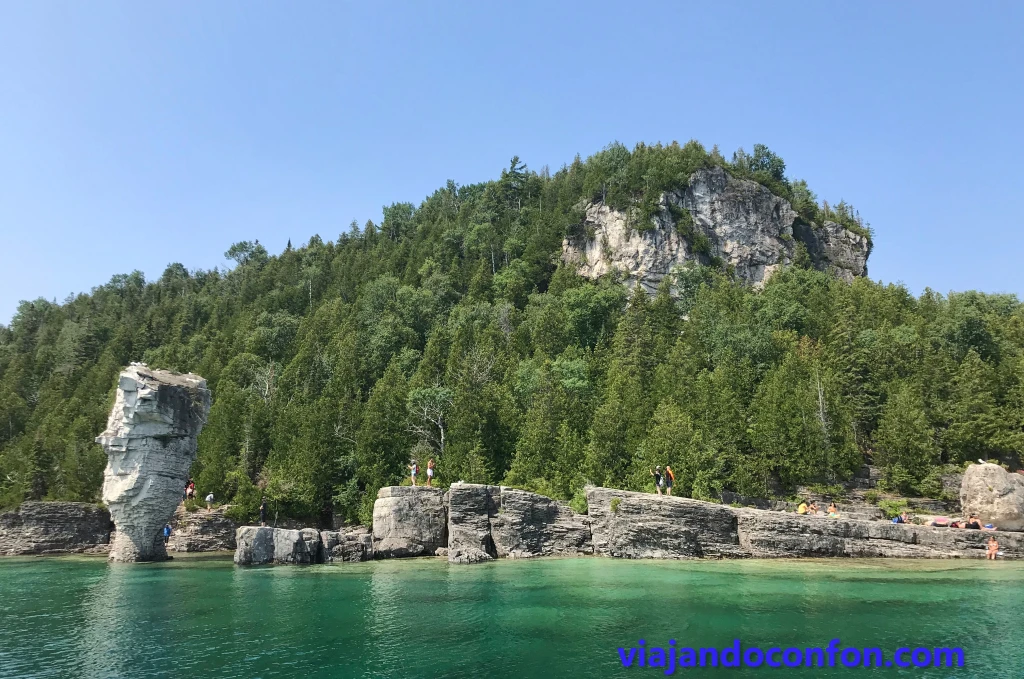
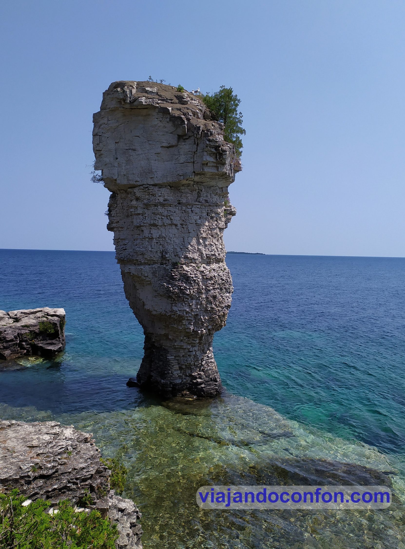
Flowerpot Island is a small uninhabited island in Lake Huron, part of the Fathom Five National Marine Park.

Before going to the island, the boat gave us a tour of the lake, showing us a 17th century shipwreck and telling us a little of the history of the offshore islands.

Flowerpot Island

We arrive at Flowerpot Island. As soon as you get off, you are offered a rubbish bag because there are no rubbish bins on the island. It is (logically) forbidden to leave rubbish there.

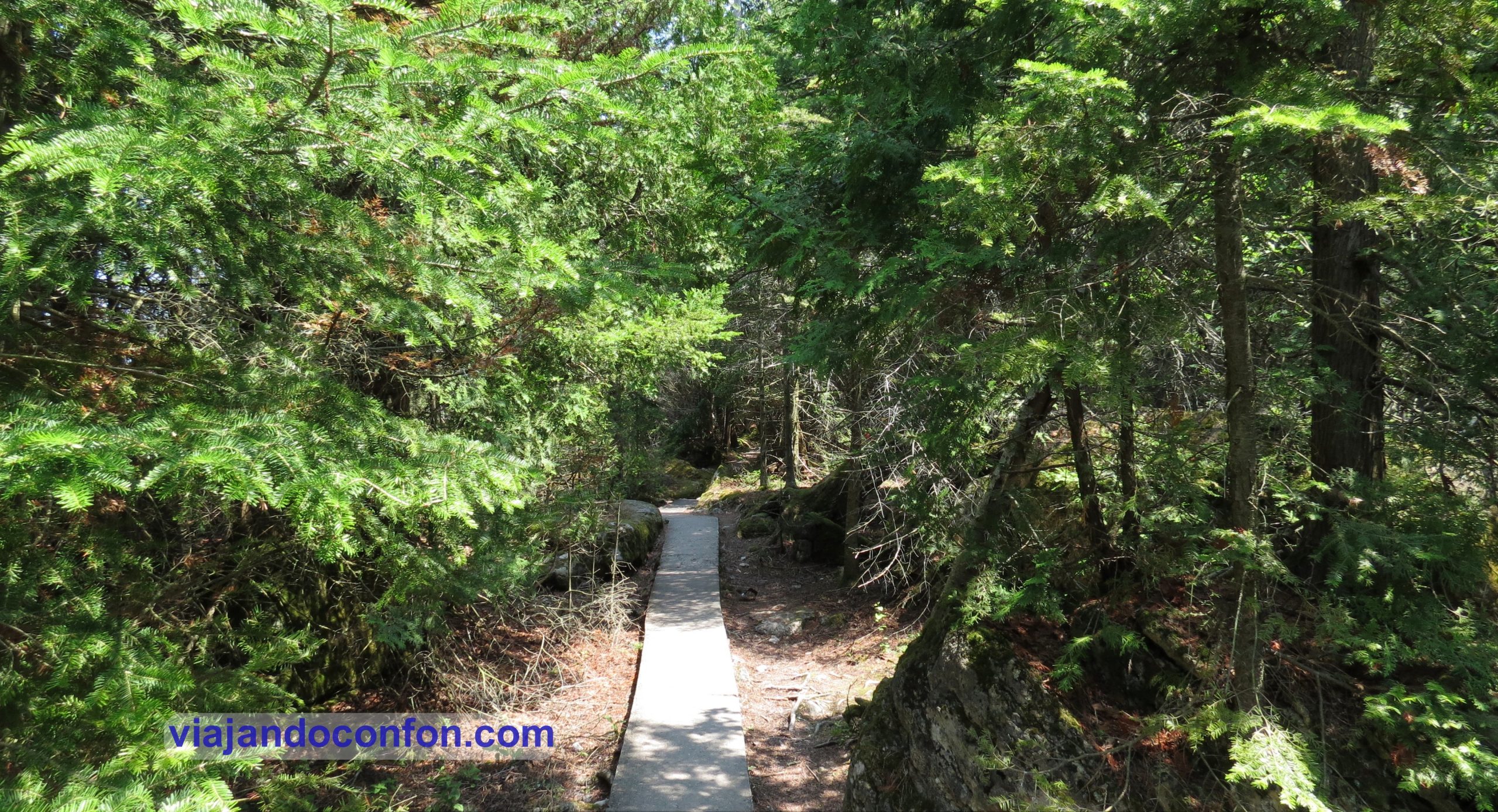
We took the hiking route around the island. It is a beautiful place, very wooded. On the coast you can see rock formations in the shape of columns called flowerpots, which give the island its name.

Flowerpot Island

The entire hiking route takes about three hours to complete. You pass several points of interest such as a cave, a power station or a small museum in the lighthouse keeper’s house. At the end of the hike, a good swim in the lake, only for the brave, because even though it was the middle of July, the water was freezing cold.

Flowerpot Island

In the afternoon we get back on the boat for the return trip, which goes straight to Tobermory without any sightseeing. We get in the car and head for our next accommodation. We are in the city of Barrie (240km), near the entrance to the Algonquin Provincial Park.

Algonquin Provincial Park

There are plenty of activities to do in the park, although we focused on hiking.

The first was the Whiskey rapids trail of about 2 kilometres.

Just after entering the trail, as in almost all of them, there is a notebook where you write down your details in case you get lost.

It goes fairly quickly but has several drawbacks. The first is that in summer there are no rapids (I suppose they are formed with the thaw in spring) and the second is that the mosquitoes are a real cloud and are the size of sparrows. This was hell, neither the mosquito patches nor the liquid repellents we used were of any use. They are the ones we took to Vietnam and Japan, with great success. They got on us and on top of that they went through our clothes. To top it off, my partner had an allergic reaction and broke out in fierce hives.

Algonquin Provincial Park

A ten-minute drive from there, the two-kilometre Peck Lake Trail also awaited us. A very easy and quiet route along the Peck Lake. Luckily there were almost no mosquitoes on this one and it went very well. The trail is really beautiful.

Peck Lake

After this route we stopped for a picnic lunch at a roadside picnic area to get our strength back. I was very amused (as well as scared) to see bear-proof rubbish bins.

Algonquin Park

After the break it was time for the penultimate route: the Big Pines Trail, which was about 3 kilometres long and also quite easy. Luckily there were hardly any mosquitoes and it went very well. It goes through the deep forest where you can find gigantic and very old pine trees. I loved it.

The next one was not a hike as such, but the Algonquin Logging Museum. It is an open-air museum in the form of a mile-long trail that shows you how the region’s loggers lived and worked and the evolution of their work. It is really interesting and recommendable. It is also free, although you can leave a donation.

Algonquin Logging Museum

We finished our visit just as the museum was closing so we got back in the car and headed out of the park towards Kanata on the outskirts of Ottawa (396km from Barrie) where we had our next accommodation.

July 28th

We had to get up early again to cover the 106 km that separated us from today’s visit, Parc Omega, in the province of Quebec. It is a park of native animals in semi-freedom.

I’m not one of those who likes zoos. Neither aquariums, nor those kind of places where animals are confined for exhibition. But in this case they were local species and the enclosure where they move around is really gigantic (it took up almost the entire tank of the car).

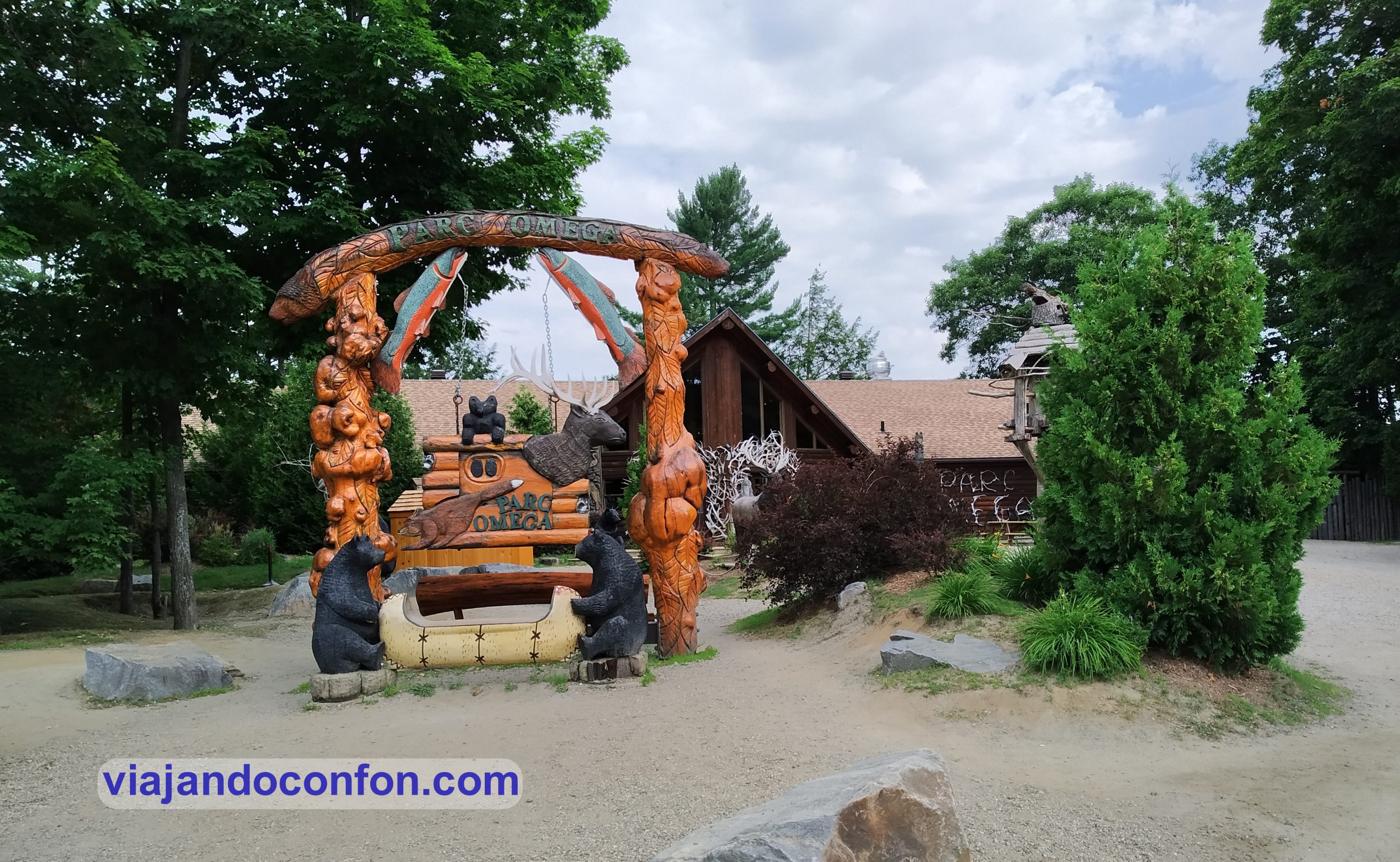
You drive around in the car, with the radio tuned to a specific station where you are given explanations of the park and the animals come looking for you to give them some carrots that you have previously bought at the visitor centre.

Parc Omega

Halfway there is another visitor centre with souvenir shops and restaurants. There you can take a tractor-drawn shuttle to a farm with animals ideal for the little ones. There are also a couple of walking trails.

In the visitor centre there is also an exhibition of birds of prey and they also show you how the wolves live in the area.

A little further on, on the shore of a small lake, there is a picnic area where we had a picnic lunch. Then we took the trail along the edge of the lake, which is also a museum with totem poles of the indigenous people of the different regions of Canada.

Parc Omega

We spent the day at the park and had a very, very good time. It is certainly a visit that children will love, but also adults.

In the afternoon we set off desperate to find a petrol station as the car’s tank had been on reserve for some time and we still had 270 kilometres to go to our next accommodation: a charming little house very close to the lake in a village called Saint-Jean-des-Piles near the entrance to Le Mauricie National Park.

One important note: petrol in Canada is really cheap, about 0.80€ (0.97$) a litre.

We arrived in the village around 9pm. We left our stuff in the flat and went in search of a restaurant.

Nearby was the Bistro Le P’tit Canot. There we were told that the cook was ill and the kitchen was closed, which was impossible. However, there was a young man eating a plate of spaghetti at a table.

Canada

They told us that we could go to the restaurant Marina le St-Jean which closed at 10 o’clock. So we went there, by then it was almost 9.15. We asked if we could have dinner and they said yes. At that moment the cook came out barking saying that the kitchen was already cleaned and that they were no longer serving food. So we rushed to Shawinigan, the biggest town nearby, before the hypermarket that had opened closed, so we could buy something for dinner.

July 29th

Today it was time for sport. We headed for the entrance to Le Mauricie National Park.

At the visitor’s centre we were very well informed about the way to follow and what to do. The man there spoke French, English, Italian and Spanish, so he was perfect.

He told us that the people of Quebec like Spanish very much, that it is studied in school and that they love to practise it when they can. Later on we became aware of this. There we paid the corresponding fee which was 15$ (10.34€) per car.

We drove to Lake Wapizagonke. There we hired some canoes and went across the lake, 4.6km in total.

Lake Wapizagonke

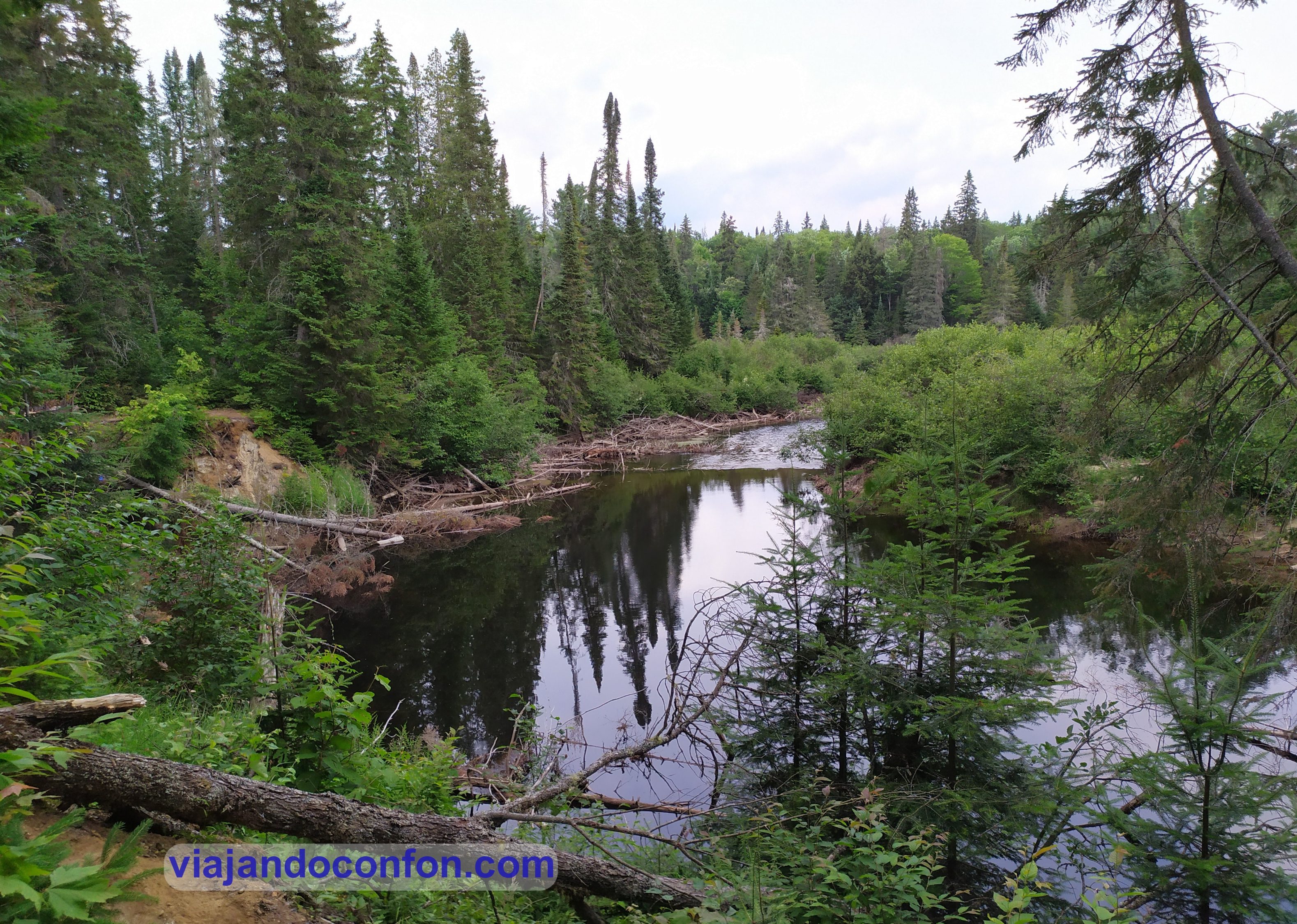
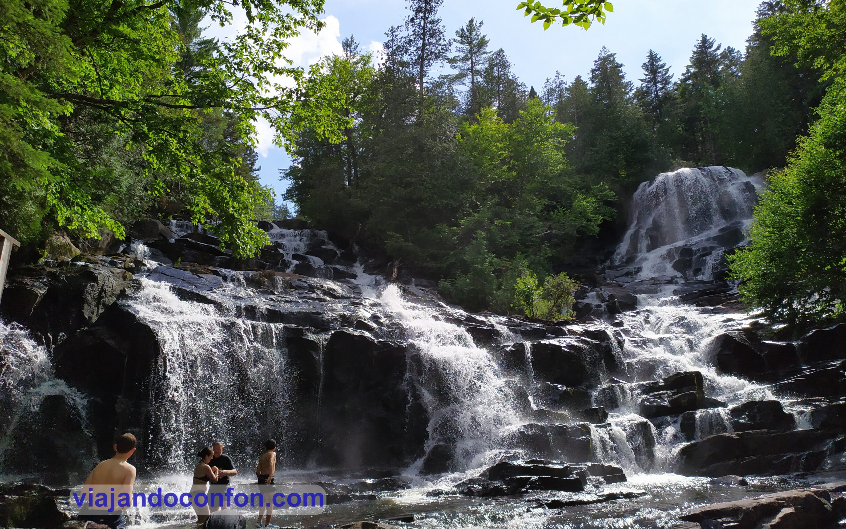
When we reached the end we tied up the canoes. We smeared ourselves with mosquito repellent, as we had encountered a veritable plague of mosquitoes. Then we set off on the 3.4km hike to the Waber waterfalls. Fortunately, the higher you went, the less mosquitoes there were.

We reached the waterfalls and they were simply spectacular. Luckily they can only be reached by the method we used so there were not too many people and they are very well preserved.

There are pools in which you can get into to cool off from the oppressive humid heat and relax from the hike. Of course, the water was too cold.

Waber waterfalls

After a picnic lunch it was time to say goodbye to the waterfalls and start the long walk back. Another 3.4km of hiking and another 4.6km of canoeing back to the car.

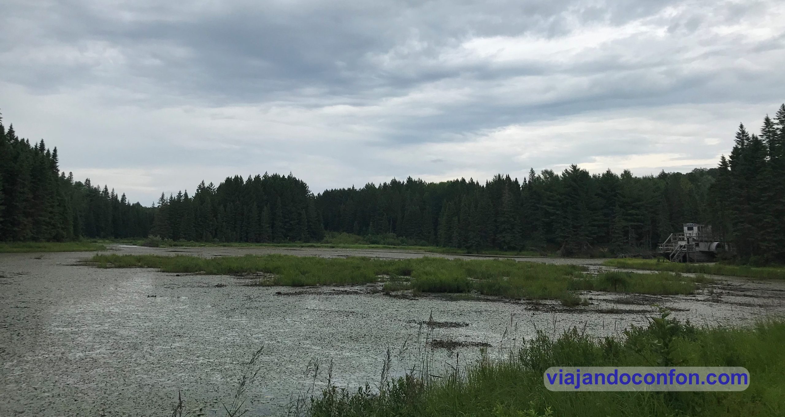
On the way back, in the car, we stopped at the viewpoint “le passage” from where we could see an incredible panoramic view of Lake Wapizagonke and where there are explanatory panels about the formation of the area, flora, fauna etc…

Before leaving the park we had a great stroke of luck and a bear crossed in front of the car, without any hurry, so we were able to contemplate it quite calmly.

Lake Wapizagonke

July 30th

It’s time to return gradually to Toronto. First stop Ottawa. After travelling the 354 km from Saint-Jean-des-Piles we arrived in the capital of the country. We left our things in the flat in Gatineau.

Gatineau is a city located in Quebec, on the north bank of the Ottawa River, just opposite the capital of Canada.

We took the opportunity to have lunch in a nearby pub, the Brasserie Gainsbourg. A small craft beer, a poutine, fish and chips and burgers. It was all very tasty.

Now full of energy and after a downpour that seemed like the universal deluge, we headed for Parliament Hill.

Parliament Hill Ottawa

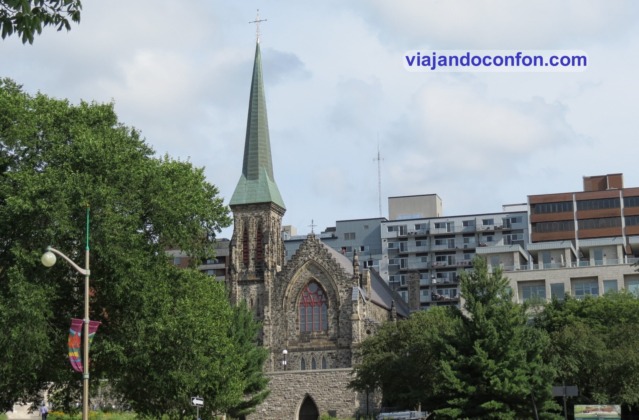
Just across the Ottawa Portage Bridge, we come to Christ Church Cathedral, Ottawa’s Anglican cathedral.

In 1824, the Reverend Amos Ansley began preaching in a school. By 1826 a small stone church was opened.

In 1841, construction began on a new church, which lasted two years until 1843, when it was consecrated and named Christ Church. By 1872 it was decided to demolish it in order to build a larger one. This was inaugurated in 1873.

On Easter Day 1897, it was formally announced that Christ Church would become the cathedral of the new diocese.

Christ Church Cathedral Ottawa

A little further on is the Supreme Court of Canada building. It was designed by Ernest Cormier and built between 1939 and 1946. It is worth noting that the foundation stone was laid by Queen Elizabeth, consort of King George VI and later known as the Queen Mother.

Next to it (more or less) is the Justice Building, designed by Thomas W. Fuller and built between 1935 and 1938.

Next to it is the Confederation Building, built between 1927 and 1931 in the Gothic style. It was designed by Richard Cotsman Wright and Thomas W. Fuller.

Confederation Building Ottawa

A little further on we come to the Canadian parliament building. Parliament is divided into three buildings. The Centre Block, opened in 1927, replacing the previous building from 1866, which went up in flames, contains the Senate and Commons chambers. At the front is the clock tower and at the rear is the library.

Canadian parliament building

The East Block (opened in 1866) and the West Block (opened in 1865) contain the offices of ministers and senators, as well as meeting rooms and other administrative spaces.

It can be visited inside by guided tours.

In the centre of the grounds is the Centennial Flame. It commemorates Canada’s centennial as a Confederation, lit on 1 January 1967.

The flame is surrounded by a fountain bearing the coats of arms of Canada’s 13 provinces and territories. The Nunavut Territory’s coat of arms was not originally there, as it was not created until 1999. Its coat of arms was installed on 13 December 2017.

We strolled around the area in peace and quiet as the days were beginning to show.

Next to Parliament Hill are the locks of the Ridau Canal. The canal connects Ottawa with Lake Ontario and the St. Lawrence River in Kingston. The name Rideau (French for curtain), is derived from the curtain-like appearance of the twin falls of the Rideau River where they join the Ottawa River.

Ridau Canal

The canal was opened in 1832 as a precautionary measure in case of war with the United States. Today it is used for recreational activities. The system’s locks are the oldest continuously operating locks in the Americas and open for navigation in mid-May and close in mid-October.

what to do in ottawa

Across the canal is the spectacular Château Laurier, a luxury hotel in a beautiful palatial building, designed in the French Gothic style. The hotel was inaugurated in 1912 and in 1980 was designated a national historic site.

Château Laurier Ottawa

We rested for a while and went over to the National Gallery of Canada to see the building from the outside, which was already closed. It is one of the largest art museums in North America by exhibition space.

The gallery was established in 1880 in the Second Supreme Court of Canada building. In 1911 it moved to the Victoria Memorial Museum building and in 1960 to the Lorne Building.

By 1988 it was finally moved to the current building, created by Israeli architect Moshe Safdie and built of glass and granite. The museum’s permanent collection includes more than 93,000 works by European, American, Asian, Canadian and indigenous artists. It also hosts temporary exhibitions.

National Gallery of Canada

In the square in front of the museum is The Maman statue, a sculpture of a spider by the French-American artist Louise Bourgeois, created in 1999, the same spider statue that can be found next to the Guggenheim Museum in Bilbao, in the Tuileries Garden in Paris or in Tokyo’s Roppongi Hills.

Opposite is Notre-Dame Cathedral, a Roman Catholic basilica, the oldest and largest church in Ottawa and the seat of the city’s Catholic archbishop.

The Maman statue and Notre-Dame Cathedral in Ottawa

In 1832, the first wooden church was built on the site. It was demolished in 1841 to make way for a larger church. It was designed by Antoine Robillard and Father John Francis Cannon, who requested a neo-classical design.

In 1844 with the lower section completed, the Oblate Fathers took over the administration of the parish. They decided to redesign the church in a neo-Gothic structure, a style that was growing in popularity.

what to do in Ottawa

From there, exhausted, we strolled to ByWard Market. It is a shopping and entertainment district in the city centre. It includes the market buildings and open-air market along George, York, ByWard and William Street.

In 1827 the first market building was built along with a courthouse behind it on George Street, which were dismantled in 1842.

On Saturday 6 November 1848 two new buildings were opened. One in the Lower Town, built of timber. With space for market stalls on the ground floor and a well-lit upper floor to be used for public meetings. The one in the Upper Town became the town hall until 1878. And so various buildings evolved until the present day.

Ottawa

The area around the market is a place where you’ll find many restaurants and places to have a drink. This is also where the giant Ottawa sign is located for us tourists to take pictures. I found the Bywan market very hipster and touristy so we decided to have dinner in the flat and rest early.

July 31st

It’s another early start today. We had breakfast and set off for the city of Gananoque (167km). There we booked a cruise that toured the Thousand Islands, an archipelago of 1,864 islands.

It is divided by the border between Canada and the United States. It lies at the mouth of the St. Lawrence River at one end of Lake Ontario. The Canadian islands are in the province of Ontario and the US islands are in the state of New York.

The islands vary in size, ranging from 100 square kilometres for the largest, to the smallest, which contains only one small residence.

To count as one of the Thousand Islands, the island must have at least one square foot (0.093 m²) of land above water level year-round and support at least one living tree.

Hub island
Hub Island, the smallest island

We bought the two and a half hour option. It consisted of a tour around the most important islands (without disembarking on any of them) while they explained the history of the place and some curiosities.

Heart island
Heart Island

The excursion is very interesting and entertaining. The ship also has a bar where you can have a drink while you enjoy the tour.

By the time the tour was over it was a bit late so we decided to have lunch at the cruise company’s restaurant and then set off back to Toronto (290km).

August 1st

Today was a relaxing walk around Toronto. We went to Casa Loma although we decided not to go inside as it did not attract our attention.

It is a neo-Gothic style mansion and garden in downtown Toronto. It was built between 1911 and 1914 by architect E. J. Lennox, as a residence for the financier Sir Henry Pellatt.

Casa Loma

In 1924 the City of Toronto repossesses Casa Loma due to unpaid debts and taxes. Henry Pellatt goes bankrupt after the expropriation of his power companies and the decline of his real estate business. This was due to the First World War. After this, the house was abandoned for years.

In 1937 it was leased by the Kiwanis Club of West Toronto. Later, the Kiwanis Club of Casa Loma (KCCL) began to exploit the castle for tourism. They managed the house until 2011.

Casa Loma Toronto

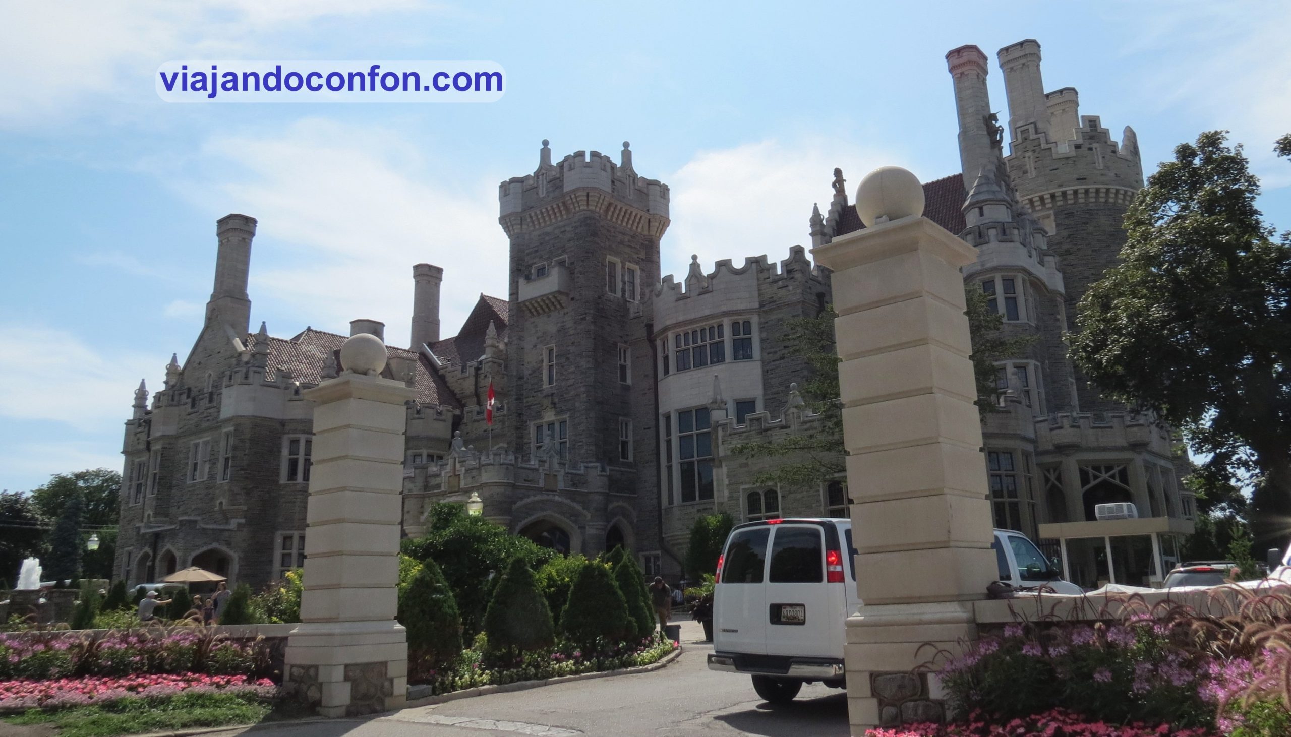
Because of its unique architectural character in Toronto, Casa Loma has been a popular location for film and television shoots. It is also a popular location for wedding ceremonies.

After a tour of the house we went for a walk downtown past some university fraternities. We also bought some souvenirs.

On this day we ate at the Salad King restaurant, a well-known Thai restaurant, which was very good and not expensive.

With renewed strength we continue strolling through the centre until we reach Queen’s Park. It is an urban park in the city centre inaugurated in 1860 by Prince Edward of Wales. It is named after Queen Victoria.

The park is the site of the Ontario Legislative Building, which houses the Legislative Assembly of Ontario.

Construction of the Ontario Legislative Assembly Building began in 1886 to the design of architect Richard A. Waite and opened in 1893. It has undergone numerous extensions, most recently in 1968 and 1969.

Ontario Legislative Building

There we sat on the grass and ate some Japanese cheesecakes that we had bought, which were to die for. We bought them in a shop called Uncle Tetsu’s Japanese Cheesecake very close to Dundas square.

After the break we continued walking past several faculties of the University of Toronto until we reached Kensington market. It is a distinctive multicultural neighbourhood in the centre of Toronto, with little shops and places to eat and drink something very hipster.

There we sat down for a drink, making time to go to the CN Tower where we had dinner at its revolving restaurant.

Toronto

The CN Tower is a 553-metre-high communications and observation tower. It was built between 1973 and 1976. Its name “CN” originally referred to Canadian National, the railway company that built the tower.

Today you can climb it to admire the incredible views of the city and to eat in its 360º restaurant, which slowly rotates to enjoy the view of Toronto. There are also various activities such as a walk around the outside at the top of the tower (how scary).

What can we say about the views from the CN Tower… They are simply spectacular and the sunset is amazing.

CN Tower

The dinner, apart from the view, was very, very good. It was modern cuisine but you don’t go hungry. You can choose a menu for 65$ (45€) or order from the menu, but the latter option is very expensive. The good thing is that it includes entrance to the tower.

CN Tower

After dinner we went back to the viewpoint of the tower, taking advantage of the fact that there were hardly any people around to enjoy the views for a while longer and take a good photo.

CN Tower

On leaving the tower we took a stroll around the surrounding area and took advantage of the late hour to take a photo at the Canada sign, which during the day is impossible due to the queues that form.

August 2nd

Last day in Canada. Quite exhausted from so many non-stop days, we left a little later for a last walk around Toronto. We bought the last souvenirs.

In the Art Gallery shop they gave us a collection of art books for the purchase we made. It was heavy as hell. With all that weight we continued walking around. We had breakfast at another Sunset grill (where we had breakfast on the first day) and went to look at the lake for a while at the Harbour front.

Toronto

We flew back with KLM. The plane was very old and the seats were very narrow, almost no leg room. The truth is that it was a really uncomfortable flight. However, the crew was very friendly and the food was very good.

We left around 11 pm and landed in Amsterdam at 12 noon. Two hours later the flight to Bilbao was leaving. This was also a KLM plane and it was one of the small ones with only two rows of seats. Incredibly, there was much more legroom and it was much more comfortable than the previous one.

what to do in Toronto

Balance of the trip

Canada impressed me. Its spectacular landscapes, its wildlife and, above all, the great kindness and friendliness of the Canadians. What impressed me most about them is the joy and the incredible treatment they have at work, where it seems that whatever it is, they love the job.

We plan to return to the country one day and visit the other coast, which must also be spectacular.

NEXT ENTRY

Huesca

En esta entrada descubriremos todo lo que debemos saber sobre Huesca, la pequeña ciudad de la Comunidad Autónoma de Aragón.

Síguenos en Redes Sociales:

Huesca

Información general

Huesca, con unos 54.000 habitantes, capital de la provincia homónima en la Comunidad Autónoma de Aragón.

Breve historia de Huesca

Los primeros asentamientos de la ciudad datan del año 4000 a.C. del que se han encontrado cerámica y sílex de cronología neolítica. Se sabe también de la existencia de un poblado o campamento perteneciente a la Edad del Bronce, entre el 1800 y el 1500 a.C.

También se han encontrado restos de una necrópolis de la Edad del Hierro de entre el 400 a.C. al 100 a.C. Más tarde se ubicó aquí una ciudad celtíbera llamada Bolskan, ocupada por los suessetanos.

Hacia el 179 a.C. el pretor romano Aulo Terencio Varrón conquista la ciudad de Bolskan, respetando la ciudad pero renombrándola como Osca.

Aquí tienes un enlace con actividades y tours muy interesantes para hacer en Huesca:

que hacer en Huesca

*Nos ayuda a mantener el blog

En el 30 a.C. Osca adquiere la condición privilegiada de municipio romano, con la que todos sus habitantes pasaban a ser ciudadanos romanos de pleno derecho.

Entre los siglos I y IV se instala el cristianismo poco a poco. Su santo, San Lorenzo, es su patrón del que la tradición señala que sufrió el martirio en Roma en 258. Su segundo patrón, San Vicente de Huesca, sufrió martirio en Valencia entre los años 303 y 304.

En 476, con la desaparición del Imperio romano de Occidente, Osca pasa a formar parte del reino visigodo. Para el año 598 se realiza un Concilio de los obispos de la provincia Tarraconense. En 673 el rey visigodo Wamba se hospedó en Osca para sofocar la revuelta del duque Paulo.

Más tarde, en el año 719 cae bajo dominio musulmán siendo una de las ciudades más septentrionales de Al-Ándalus. Éstos cambian su nombre por el de Wasqa.

En 799, según los Anales del Reino de los Francos, se entregan a Carlomagno las llaves de la ciudad, en señal de su sumisión.

El dominio franco, sin embargo, no se hizo efectivo, y en los años 801, 811 y 812 fracasaron nuevos intentos carolingios de reconquista de la ciudad. Tras la desaparición del califato de Córdoba, Wasqa pasa a formar parte de la taifa de Zaragoza, gobernada sucesivamente por las dinastías tuyibí y hudí.

Huesca

En 1096 el rey Pedro I de Aragón conquista la ciudad derrotando a a Al-Musta’in II de Zaragoza en la batalla de Alcoraz y en 1191 se firma la Liga de Huesca entre los representantes de los reyes Alfonso II de Aragón, Sancho VI de Navarra, Alfonso IX de León y Sancho I de Portugal con el propósito de hacer la guerra al reino de Castilla, donde reinaba Alfonso VIII de Castilla.

Durante el siglo XVII llega un periodo de gran esplendor cultural a Huesca. Se construyen las iglesias de San Lorenzo y Santo Domingo, el edificio octogonal de la Universidad o la presa de Arguis. También hubo en ese siglo grandes personajes como Vincencio Juan de Lastanosa, mecenas de Baltasar Gracián y Francisco de Artiga.

Durante la Guerra de Sucesión en el siglo XVIII, El rey Felipe V abole el antiguo concejo oscense, nacido en la Edad Media y lo sustituye por un ayuntamiento similar a los castellanos. A su frente estaban un corregidor, por lo general militar, y doce regidores oscenses fieles a los Borbones.

hoteles en Huesca

*Nos ayuda a mantener el blog

Diarios de nuestros viajes

ENTRADA SIGUIENTE

Zaragoza

En esta entrada descubriremos todo lo que debemos saber sobre Zaragoza, la capital de la Comunidad Autónoma de Aragón.

Síguenos en Redes Sociales:

Zaragoza

Contenido:

Iati seguros

*Nos ayuda a mantener el blog

Información general

Zaragoza es la capital de la Comunidad Autónoma de Aragón. Con una población de casi 700.000 habitantes, es la 5ª ciudad más poblada de España.

Breve historia de Zaragoza

La ciudad cuenta con más de dos mil años de historia. Siendo los documentos más antiguos del siglo VII a. C. con los restos de unos poblamientos del final de la Edad del Bronce.

Los primeros asentamientos urbanos datan del siglo III a.C.. Es una ciudad ibérica llamada Salduie que se identifica con el nombre de «Salduvia» en un texto de Plinio el Viejo.

Entre los años 25 y 12 a.C. se funda la ciudad romana de Caesaraugusta por Octavio Augusto. Lo hace con veteranos de las guerras cántabras. Poco después se convirtió en el centro urbano más importante del valle medio del Ebro.

Zaragoza
Teatro Romano de Caesaraugusta

En el año 452 fue conquistada por los suevos y en el 466 por los visigodos, quienes la incorporaron al reino de Tolosa.

En 714 fue ocupada por el sarraceno Musa ibn Nusair. Entonces se convierte en un centro musulmán importante llamado «Medina al-Baida Saraqusta» que, en 788 intenta ocupar Carlomagno aunque sin éxito.

Durante el siglo XI la ciudad musulmana alcanza su máximo esplendor durante el reinado de Al-Muqtadir (1046-1081). Este amplió su reino con la anexión de la taifa de Tortosa y la taifa de Denia y sometió a vasallaje a la de taifa de Valencia. Es entonces cuando se construye el espectacular Palacio fortificado de recreo de la Aljafería.

En el año 1118, Alfonso I el Batallador conquista Zaragoza y pronto se convierte en la capital del Reino de Aragón, siendo la sede en la que se coronan los reyes de la Corona de Aragón.

La unión dinástica de la Corona de Castilla y la de Aragón la transformó en una ciudad más de la monarquía de los Austrias.

Hoteles en Zaragoza

*Nos ayuda a mantener el blog

Diarios de nuestros viajes

Descubre las mejores actividades y tours en Zaragoza con Civitatis:

Que hacer en Zaragoza

*Nos ayuda a mantener el blog

ENTRADA SIGUIENTE

Lithuania 2012 (III): we visit Kaunas and return to Vilnius

Today we travel to Kaunas, Lithuania’s second city but with a lot of charm.

August 3rd

At 13.50 we left by bus for Kaunas. Three hours later we would arrive at Kaunas station. The ticket cost us 42.30 Litas (12.25€).

Kaunas

Kaunas is located at the confluence of the Niemen and Neris rivers; it is the second most populous city in the country after Vilnius and was the capital during the first Republic of Lithuania between 1920 and 1939.

The city was founded in 1361 and became the most populous city of the Trakai Voivodeship during the Grand Duchy of Lithuania. In 1795 the Russians occupied the city and shortly afterwards it was attacked by Napoleon’s troops.

The 1918 declaration of independence made Kaunas the provisional capital of the Republic of Lithuania, as Vilnius was under Russian and later Polish control.

Kaunas
Views from the accommodation

By the late 1930s it had become Lithuania’s most populous city, but during World War II it suffered first the Soviet invasion (1940-1941) and, after a brief civil uprising, the German occupation (1941-1944).

The Nazi army carried out a holocaust of the Jewish population with the establishment of the Kovno Ghetto, leaving more than 30,000 dead. The Soviets recaptured the city in 1944 to establish the Lithuanian Soviet Socialist Republic. At the end of the war the capital was moved to Vilnius, now under Lithuanian sovereignty.

From the bus station we walked to the flat, about 2km away. This time we chose a tourist rental, a rather elegant flat that cost 49€ per night.

As I had arrived a bit sick, we decided to rest a bit. We went out for dinner at a nearby supermarket and went to bed early.

August 4th

We get up early and head out onto the streets. After breakfast we go to Laisvės Alėja (Freedom Avenue), a well-known pedestrian boulevard with many shops and restaurants. We stroll until we reach Šv. Arkangelo Mykolo bažnyčia (Church of St. Michael the Archangel).

The church of St. Michael the Archangel is a Roman Catholic church built between 1891 and 1895 in Neo-Byzantine style when Kaunas was part of the Russian Empire. It was originally an Orthodox church serving Russian troops stationed in the city, although it was planned to be a Roman Catholic church before the January 1831 uprising.

The church was integrated into the Kaunas Fortress. As was customary for military churches at the time, the construction of Kaunas Cathedral was financed in equal parts by the Military Ministry and by donations from military men.

Šv. Arkangelo Mykolo bažnyčia (Church of St. Michael the Archangel)

After the fall of the Kaunas Fortress during World War I, the Germans took the bells from the church and took them to Germany. The church remained closed until 1919.

In the inter-war period, the cathedral became a Roman Catholic church of the Lithuanian garrison in Kaunas. During the Soviet era it was used as an art gallery, and after its dissolution it resumed its Roman Catholic ecclesiastical activity.

From here we head to the Žaliakalnio funikulierius (Žaliakalnis funicular), the oldest funicular in Lithuania built in 1931. It runs a distance of 142 metres to the Basilica of the Resurrection of Christ. It quickly became a very popular means of transport, carrying some 5 million passengers between 1950 and 1970.

Žaliakalnio funikulierius (Žaliakalnis funicular)

We take the funicular, which costs 1 Lita per person (€0.30), up to Kauno Kristaus prisikėlimo bažnyčia (Basilica of the Resurrection of Christ), a monumental Roman Catholic church consecrated in 2004.

After Lithuania regained its independence in 1918, the idea of building a church as a national shrine and a symbol of gratitude to God for the freedom regained in the city of Kaunas, then the temporary capital of Lithuania, began to gain ground.

In 1922, the city of Kaunas gave the land for the construction and the design of the engineer Karolis Reisonas was chosen in a competition, and in 1933 the building permits were granted.

Kauno Kristaus prisikėlimo bažnyčia (Basilica of the Resurrection of Christ)

The cornerstone of the church, brought from the Mount of Olives in Jerusalem, was solemnly blessed and laid in the foundations in 1934. Construction proceeded apace until the Soviet Union occupied the country, when the building was confiscated and converted into a radio factory. The building was then remodelled, with three storeys in the side aisles and five in the central nave. The crosses were removed and the chapel demolished.

In 1990, the Lithuanian Soviet Socialist Republic forced the reconstructed building to be returned to its original form, but it was returned in a deplorable and dilapidated state.

Reconstruction then began, with some changes to the original plans. But the work was hampered by a lack of funds. It was not until 1997 that the work was accelerated thanks to contributions from the Lithuanian government.

The church was consecrated in 2004 and the work was finally completed in 2005.

Kauno Kristaus prisikėlimo bažnyčia (Basílica de la Resurrección de Cristo)

The building is really curious although it doesn’t look like a church. We paid 8 Litas (2.30€) each to enter. The interior is very simple and sober and you can go up to the terrace to see the spectacular views from the place.

Kauno Kristaus prisikėlimo bažnyčia (Basílica de la Resurrección de Cristo)

We walked down instead of taking the funicular and went to the building of the Vytauto Didžiojo Karo Muziejus (Vytautas the Great War Museum).

In the same building we found the Nacionalinis M. K. Čiurlionio dailės muziejus (National Museum of Art). Apart from the museums, on the square in front of the museum is the Freedom Monument, which was erected in 1928 but destroyed during Stalin’s regime. It was reinstalled in 1989.

There is also the Tomb of the Unknown Soldier and Kauno kariljonas (Kaunas Carillon), with its 49 bells ringing since 1956, and concerts are held every Saturday and Sunday at 16:00.

Tomb of the Unknown Soldier Kaunas
Tomb of the Unknown Soldier

Close by is the Devil’s Museum (Velnių muziejus). A famous Lithuanian painter, public figure and professor Antanas Žmuidzinavičius (1876 – 1966) started to assemble this collection.

The museum contains a collection of more than 3,000 devils: creations of fine and applied arts, souvenirs and masks not only from Lithuania but from about 70 countries.

It was time for lunch. We decided to have lunch at a place on the way to the old town called Hesburger, a Finnish hamburger chain that is all over Lithuania. The burgers were quite good and it was quite cheap.

After lunch we went to the bank of the Niemen river. There we came across Nemuno Sala (Nemuno Island), an island about 1.5 km long that was undeveloped until 1917, when the German army built a harbour.

In the inter-war period it served as a winter harbour and recreational facilities were built. The harbour was in operation until 1970. Today it is a beautiful recreational park in which the ‘Algirio Arena, the largest sports hall in the Baltic States, is located. It opened on 18 August 2011 with a match between the Lithuanian and Spanish basketball teams.

As a basketball lover, I had to visit it as it was here that Spain won Eurobasket 2011.

Nemuno Sala (Nemuno Island)

We leave the island and head to the old town of Kaunas. We stroll along Vilniaus gatvė (Vilnius Street), the oldest street in the city, which is part of the old medieval road to Vilnius. Here we find numerous historic buildings, built by the wealthy class of the city.

On this street you will find many shops and terraces where you can have a good Lithuanian beer… which we did.

Vilniaus gatvė (Vilnius Street)

One of the most notable buildings on the street is the Cathedral Basilica of St. Peter and Paul (Kauno Šv. apaštalų Petro ir Povilo arkikatedra bazilika), a Roman Catholic cathedral basilica dedicated to the apostles St. Peter and St. Paul.

The exact date when the first Gothic-style church was built is unknown, but it is first mentioned in written sources in 1413. The construction work was not completed until 1624.

The church was badly damaged in 1655 during the Russo-Polish War but was rebuilt in 1671 with the addition of some Renaissance features. During a raging fire on the roof in 1732, both towers were destroyed and only one was rebuilt.

The present appearance of the building is the result of a new renovation in 1800. The church was promoted to cathedral status by Pope Leo XIII in 1895 and received the title of Basilica in 1926, when Pope Pius XI reorganised the Diocese of Samogitia into the Metropolitan Archdiocese of Kaunas.

Kauno Šv. apaštalų Petro ir Povilo arkikatedra bazilika

Motiejus Valančius, the Bishop of Samogitia, who was also a historian and one of the best-known Lithuanian writers of the 19th century, was buried in a crypt of the church in 1875.

On the side façade facing Vilniaus gatvė is the mausoleum of Jonas Mačiulis – Maironis, a Lithuanian poet, professor and theologian, considered one of the leading figures of Lithuanian literature in the late 19th century.

Kaunas

A little further on from the church we come to Kauno Rotušės aikštė, the town hall square. Here we find (logically) the town hall (Kauno rotušė).

The construction of the town hall began in 1542 as a single-storey building with an unpainted façade and vaulted cellars. In the 16th century, the first floor and the eight-storey tower to the east of the building were built.

By 1638 it was built in the Renaissance style, and between 1771 and 1775 a second restoration was carried out by the architect J. Matekeris.

In the following centuries, it was used for various functions, such as an orthodox church, a munitions depot and the residence of the tsars.

Kauno rotušė

Between 1869 and 1944 it was used as a theatre. After the Second World War it became the municipal archive.

The building was restored between 1968 and 1973 under a project by the architect Žibarts Simanavičius and became the town hall. Today its functions are mainly weddings, but it is also the place where the authorities are received and official ceremonies are held.

On the town hall square is also the Church of St. Francis Xavier (Kauno šv. Pranciškaus Ksavero (Jėzuitų) bažnyčia).

It was built by the Jesuits in 1666 and consecrated in 1722. On the same site, they previously built their first residence in Kaunas in 1642 and established a chapel in the House of Perkūnas in 1643.

By 1824 the tsar handed the church over to the Orthodox Church, but a century later it reverted to the Jesuits. During the Soviet occupation, it was converted into a technical school and sports centre. After independence in 1989, it was once again in Jesuit hands.

Kauno šv. Pranciškaus Ksavero (Jėzuitų) bažnyčia

After a short evening stroll around the area, we looked for a place to have dinner and went to rest. Last day in Kaunas tomorrow.

August 5th

We get up at a reasonable hour, have breakfast and go to the street.

We return to Vilniaus gatvė, a street you will walk along many times. After a coffee, we head to Kaunas Castle (Kauno pilis).

Located on the bank of the Nemunas River near the confluence of the Neris River in the Confluence Park. It is believed to have been built in the mid-14th century in Gothic style.

By 1362, the castle was besieged by the Teutonic Order. At that time, the castle walls were more than 11 metres high. Inside was a garrison of about 400 Lithuanian soldiers commanded by Vaidotas, son of Duke Kęstutis.

After three weeks, the Knights managed to breach the castle walls and shortly afterwards the castle was taken. Of the 400 soldiers defending the castle, 36 survived. On Easter Sunday 1362, the knights celebrated a mass in the castle to commemorate their victory.

Kauno pilis

In 1384, the Lithuanian army besieged the castle and took it back. After the Battle of Grunwald, Kaunas Castle lost its strategic military importance and was used as a residence.

During the 16th century, the castle was strengthened and adapted to new defensive purposes by building an artillery bastion near the round tower.

The castle was used as a prison in the 18th century; later, the Russian administration granted permission for the construction of houses on the castle’s territory, which resulted in significant damage to the castle itself.

Kauno pilis

After that, the castle was abandoned for decades until 1960. A museum was opened in the round tower, but was soon moved due to the poor condition of the tower.

The castle is restored between 2010 and 2011. A branch of the Kaunas Museum is established there. On 14 July 2018 a new sculpture “Freedom Warrior” (representing Vytis) was erected near the castle.

Opposite the castle is the Church of St. George the Martyr (Kauno Šv. Jurgio Kankinio (pranciškonų) bažnyčia). It is a church built in Gothic style between 1492 and 1502.

Kaunas

The church was badly damaged during the Napoleonic Wars. During the Soviet occupation the church was converted into a medicine warehouse.

We turn back towards the centre. After a nice walk and a well-deserved and delicious Lithuanian beer, we enter St. Peter and Paul’s Cathedral. We had not had time the day before.

We continue strolling through the beautiful historic centre of the city. We reach Perkūno namas (House of Perkūnas). This is one of the most beautiful Gothic buildings in the city. It was built in the 15th century by Hanseatic merchants and its purpose is not really known.

There is a legend about a sculpture of the deity Perkūnas found on a wall of the building, about priestesses guarding the eternal fire; however, the extensive collection of artefacts found by researchers suggests that it was a commercial office belonging to Hanseatic merchants.

Kaunas

Perkūnas is one of the most important deities in the Baltic pantheon. In Lithuanian and Latvian mythology he is the god of thunder, rain, mountains, oaks and the sky.

Today, the House of Perkūnas belongs to the Kaunas Jesuit order. The Perkūnas House houses an exhibition on the life and works of Adomas Mickevičius, an art exhibition and a concert hall.

It can be visited for a fee of €3.

A little further down is the Church of the Assumption of the Virgin Mary – Vytautas the Great (Vytauto Didžiojo bažnyčia). It is the oldest early Gothic monument in Kaunas. The exact date of its construction is unknown.

According to the Jesuit historian Albert Vijūkas Kojelavičius, Vytautas the Great built this church in 1400. Soon after, the Vilnius Franciscan monks began to guard it.

The first record of the church dates back to documents from 1439 and refers to a small wooden church. Shortly afterwards it was replaced by the present brick church. The tower was built between the end of the 15th and the beginning of the 16th century.

Kaunas

The church was spared three major fires in the city (1603, 1624 and 1668). But it was devastated during the Russian invasion in 1655. It was restored in 1669.

In 1812, after the French invasion, it became an arms depot and, after their departure, the building was set on fire. It was restored again in 1819.

During the First World War, the German army used it for storage. After their departure, the building was again badly damaged.

In 1919 it was returned to the Catholic Church and restored again. On 15 August 1920 the church was consecrated by the prelate Aleksandras Jakštas-Dambrauskas.

The church is located on the banks of the river Niemen, so we walk to the Confluence Park (Santakos parkas).

The Confluence Park (Santakos parkas) is a large 12-hectare park at the confluence of the Nemunas and Neris rivers. Here you will find Kaunas Castle, sports facilities and even a monument to Pope John Paul II.

Kaunas

It’s a perfect place to take a stroll at sunset and sit on the grass and relax for a while. And even go fishing.

After a well-deserved rest we went on our way to a nearby shopping centre called Akropolis. There we found a place called Čili Pica where we had a quiet dinner.

After dinner we went to sleep, as we had to get up early. We took the bus back to Vilnius.

Back to Vilnius

August 6th

Last day in Lithuania. We took an early bus to Vilnius.

As soon as we arrived in the city we went straight to the hotel, which was opposite the Vilnius Cathedral. This time we chose the Amberton Hotel. A 4 star hotel that cost us 61€ a night with breakfast, which we booked as a picnic as we were leaving the hotel at 3am.

Find the best hotel at the best price in Vilnius with Agoda.

Hotels in Vilnius / Lithuania

The truth is that the hotel, for a 4-star hotel, was pretty dingy, although it had a good view.

Vilnius
Views from the room

We left our things and went to do the last Lithuanian sightseeing. A stroll along Pillies Street, where there was a craft market. There we bought some souvenirs.

Then we go on our way to see a sculpture of the musician Frank Zappa… unique in the world…

And from here we go down to Gedimino Avenue, the main avenue of the city. A large shopping street closely related to the world of theatre and with numerous government buildings.

Here we had some hamburgers for lunch from a fast food chain…

The Lithuanian National Theatre of Dramatic Art (Lietuvos nacionalinis dramos teatras) is located on this street.

The theatre opened on 6 October 1940 with a performance of the play “Hope” by the Dutch playwright Herman Heijermans. At that time it was located in Basanavicius Street. The theatre moved to its current location in 1951.

The sculpture Celebration of the Muses (Mūzų šventė) by sculptor Stanislovas Kuzma, which crowns the main entrance of the theatre, has become the symbol of the National Drama Theatre of Lithuania. These figures represent the muses of Drama (Calliope), Comedy (Thalia) and Tragedy (Melpomene).

Lietuvos nacionalinis dramos teatras

This street is also home to the Mažasis Theatre (Mažasis teatras) and the Lithuanian Academy of Music and Theatre (Lietuvos muzikos ir teatro akademija).

This avenue is a beautiful promenade lined with stately buildings.

Mažasis teatras

Paseando paseando llegamos de nuevo a la calle Pillies. Allí tomamos nuestra última cena en el primer local que descubrimos de Čili Pica y temprano a la cama para madrugar.

Madrugón exagerado. Bajamos a recepción a recoger el desayuno y hacer el check out. Aquí nos pasó algo que nunca habíamos vivido. Entregamos las llaves y el recepcionista nos pasa la cuenta: 210 Lt. El hotel lo teníamos pagado mediante la web en la que lo contratamos. Se lo hacemos saber y nos pide una prueba del pago. Por suerte ya tenía mi primer smartphone y pude enseñarle el correo con el recibo del hotel y del banco.

No se si nos quería estafar o era un novato, pero nos dejó marchar pero teníamos que mandarle los recibos al correo del hotel… nunca lo hicimos.

En la puerta nos pesperaba nuestro transfer al aeropuerto, ya que a esas horas no había transporte público.

Balance of the trip

What can I say about Lithuania… A country that pleasantly surprised me. Its spectacular landscapes, its gastronomy, its culture and its kind and friendly people.

I am aware that 10 days is very little time and that we missed a lot to see. I am sure I will come back.

NEXT ENTRY

Lithuania 2012 (II): visiting Klaipėda and Curonian Spit

We continue our journey through Lithuania. Today we moved the camp and went to Klaipėda.

August 1st

Klaipėda is Lithuania’s third most populous city and the country’s main seaport, located on the Baltic Sea coast.

Remember to always travel with travel insurance. With IATI, specialists in travel insurance, you have a 5% discount for being our reader.

Brief history of Klaipėda

The town was founded in 1252 by the Teutonic Order and is called Castrum Memele (in German Memelburg) and the whole area was Christianised. The Peace of the Melno Sea in 1422 fixed the brotherhood between the province of Prussia and Lithuania. Memel was included in Prussia and the border remained unchanged until 1919. It was one of the longest unchanged borders in Europe.

At the beginning of 1474 Memel was governed by the Culm Law of the Prussian towns. In 1525, the Duchy of Memel adopted Lutheranism under the reign of Albert of Prussia. It was the beginning of a long period of prosperity for the city and the port, as the Duchy of Prussia was a Polish fiefdom and later part of the Polish-Lithuanian Commonwealth. That prosperity came to an end when, between 1629 and 1635, Memel was attacked and occupied by Sweden.

With the creation of the unified German state in 1871, Memel became the most northeastern town in Germany. After the Treaty of Versailles, the territory surrounding Memel was separated from Germany and given autonomy under French occupation. In 1923 Lithuanian troops under Colonel Budrys attacked the town and the French withdrew.

Klaipeda

Memel was reabsorbed by the German Reich on 22 March 1939, after the annexation of Austria, the Sudetenland and Czechoslovakia. In January 1945 the town was captured by the Red Army and handed over to Lithuania.

At 11.35 the bus left Vilnius station. During the journey, something happened that left a deep impression on me. At a certain point on the motorway, we overtook an old car that was being towed by a Seat Ibiza with a normal rope tied to the bumper. In Spain you get caught and you get a packet of shit.

A little less than 4 hours later we arrived at Klaipėda station. From here we walked to our hotel, the National Hotel. A 4-star hotel, very centrally located and quite cheap.

We left our things and went for a walk through the old part of the city, the central part of which looks like a typical German village. The central part of the district looks like a typical German village – have we changed countries without realising it?

The most central place is Aikštė Theater, the Theatre Square. This is the central square of Klaipeda’s old town. Originally, part of the castle moats were located here. After being filled in 1819, a market was opened here. This market evolved and grew over the years.

Aikštė Theater

The most notable building on the square is (obviously) the theatre. The time of construction of the first building is unknown, but according to 18th-century city plans, a square building called “Komedijų namais” (Comedy House), which was formerly a military building, was located here.

The new boom of theatrical life in Klaipėda began after 1818, when the German Ulbrich arrived here. A forestry trading company allowed him free use of a temporary wooden building, where he set up a 200-seat hall and opened a theatre.

At the end of the 19th century, the construction of a new two-storey brick theatre in Classicist style with an attic was completed on the site of the present theatre. In 1854 the theatre burned down during a fire in the city but was rebuilt in 1857.

In 1935 the Šiauliai Theatre was moved to Klaipeda, a town 170 km to the west, and functioned as the Klaipeda State Theatre until 1939.

Unfortunately, during our visit it was completely covered up as it was undergoing restoration work and we were unable to see it.

Another notable feature of the square is the monument to Simon Dach, a poet born in 1605 in Klaipeda when it was officially called Memel and belonged to Germany. It is a fountain installed in 1912 whose sculpture represents the barefoot girl, one of the characters created by the poet.

monument to Simon Dach

In 1939 the sculpture was removed from the square and it is said that the idea was to replace it with one of Adolf Hitler. In 1989 a replica of the original sculpture was reinstalled.

From here we went to the banks of the Danish river. We crossed the river on the Biržos Bridge. Until the 18th century, the then wooden bridge was used not only for crossing the river, but also to collect tribute from all the ships that wanted to pass over it.

In 1877, construction began on a new steel bridge designed by the Wiesbaden engineer Bernstein, which was opened in 1879. In 1904, the upper part of the bridge was redesigned so that the new trams of the city could travel over it. During the reconstruction, the bridge was decorated with two openwork Art Nouveau metal portals, to which street lamps were attached.

Destroyed during World War II, it was rebuilt to the same design in 1948 and restored in 2007.

Biržos Bridge

The city must have been in a festive mood. In the park by the river there were several little food and craft stalls. There we sat down to have some refreshments and eat kepta duona, a kind of fried bread strips with cheese, which is delicious.

Next to the bridge is Arka, a monument built by sculptor Arūnas Sakalauskas in 2003 to commemorate the 85th anniversary of the Tilsit Law and the 80th anniversary of the Klaipėda uprising. The smaller red column is made of red granite and symbolises Lithuania Minor and its cultural heritage, while the grey part symbolises Lithuania proper. The grey part at the top appears to have been broken off and represents the Kaliningrad Oblast, now part of Russia.

The inscription at the top reads: ‘Esame viena tauta, viena žemė, viena Lietuva’ (‘We are one nation, one land, one Lithuania’) in the words of the Lithuanian writer Ieva Simonaitytė.

Arka Klaipeda

From here we went to rest for a while but, on the way, we stopped at a supermarket to buy some dinner. For 18.84 Litas (5.45€) we bought a lot of things.

After the break we had a short evening stroll but went to bed early as we had to get up very early. The next day was going to be hard, very hard.

August 2nd

We got up very early, no, very early. Today we visited the Curonian Spit, a sandy spit that separates the Baltic Sea from the Curonian Lagoon. It is 98 km long, of which 52 km belong to Lithuania and the rest to the Kaliningrad Oblast in Russia.

According to Baltic mythology, the spit was formed by a very strong girl called Neringa who was playing on the beach.

Curonian Lagoon
Curonian Lagoon

The entire Lithuanian part belongs to the municipality of Neringa. Until the reform of the Lithuanian municipality in 2000, it was known as the town of Neringa, although there was never a real “town” there. It became a city in the Soviet Union in 1961 by formally combining 4 settlements into one administrative unit.

At 7.20 in the morning we were taking the ferry from Klaipeda to Smiltynés. The trip cost us 2.90 Litas (0.85€) and takes about 20 minutes to cross the lagoon. From here we took a bus to Nida. The journey cost us 11 Litas (3.20€) and takes just over an hour.

Nida is the administrative capital of the municipality of Neringa and is well known as a tourist destination and for the Nida artists’ colony, an important artistic movement in East Prussia that began around 1890 and ended with the outbreak of World War II.

Nida is the westernmost point of Lithuania and the Baltic states, near the border with the Russian enclave of Kaliningrad Oblast, and has a population of about 2,300.

Nida

Here we bought a snack for the road and went to a bike rental point that I had already booked. The bikes cost us 30 Litas (8.70€) each and we could return them at any of the points along the isthmus.

With the bikes we headed to the first point we wanted to see, the Parnidžio kopa, the Parnidis Dune or the Great Dune of Nida. A 52-metre high moving sand dune and it is believed that its name, Parnidis, comes from the phrase meaning “it passed by Nida” because this wind-blown dune has passed by the village of Nida several times.

It is possible to climb to the top but only along the marked paths. It is strictly forbidden to leave these paths to ensure their preservation.

Parnidžio kopa, the Parnidis Dune

We park the bikes and climb the stairs through the lush forest to the top and admire the breathtaking views.

Parnidžio kopa, the Parnidis Dune

At the top of the dune is Saulės laikrodis, a granite sundial built in 1995. In 2011 it had to be restored as it was destroyed during a storm. The sundial is a 13.8-metre-high stone pillar weighing 36 tons. From an astronomical point of view, the Parnidis dune is an ideal place for the sundial in Lithuania.

Saulės laikrodis

After admiring the spectacular views we set off northwards towards the ferry, although we were not going to get that far. Practically the whole way we were able to cycle along the cycle path. It’s great because you don’t run into traffic and you don’t put yourself in danger.

The next stop was Vecekrugo kopa, the Vecekrugo dune about 8 km from Nida. This is the highest dune on the Curonian isthmus at 67 metres high and you can also climb it along the marked path to admire the views, but they are less impressive than those of Parnidis Dune.

Vecekrugo kopa

Here we took the opportunity to rest in the shade and eat what we had bought in Nida. After the rest we returned to the road. After kilometres of spectacular scenery combining forest and coast, we reached the town of Pervalka, about 8 km from Vecekrugo kopa.

Pervalka is a (very) small town of about 200 inhabitants. Most of the houses are small fishermen’s buildings from the late 19th and early 20th century and most of them are located on both sides of the main street along the shores of the Curlandia lagoon.

The village is really charming. If one day I win the lottery, I’ll buy a holiday cottage here.

Pervalka

Here we buy something to eat in a little shop, a light snack to keep on pedalling. We continue riding until we reach the coast of the Baltic Sea. Specifically to Juodkrantės bendras paplūdimys, Juodkrantės beach, about 17 km from Pervalka. A spectacular beach of fine, white sand where you felt like taking your clothes off and jumping into the sea, as it was very hot that day.

Juodkrantės bendras paplūdimys, Juodkrantės beach

From here we head to Juodkrantė (literally black coast), a tourist village with about 700 inhabitants. Located in the territory of the former Prussia, it was for centuries a fishing village called Schwarzort, which experienced a tourist boom in the late 19th and early 20th century.

Here we returned the bikes to the town’s quay and got on the bus to go to the ferry. We arrived at the hotel around 7 p.m. and rested for a while before going to get some dinner.

The break got a bit out of hand and we were running a bit late. I had booked a place for dinner on the internet and we set off. After a long walk we arrived in Soviet Klaipeda: wide avenues and huge blocks of flats. There was nothing on that road and the lighting was not very bright. As we couldn’t find the place we decided to turn around and look for something in the old town. With such bad luck that it had become too late and we were no longer allowed to enter any restaurants (they close at 22.00). So we decided to buy some ready-made food in a supermarket and eat it quietly in the hotel.

what to do in Klaipeda

August 3rd

Last hours in Klaipeda. We strolled through the old town until we reached the ruins of the castle, Klaipėdos Pilis. Klaipeda Castle also known as Memelburg or Memel Castle was built by the Teutonic Knights. The year of its construction is unknown but it was first mentioned in written sources in 1252 and underwent numerous destructions and reconstructions in the following centuries.

During the 19th century, having lost its strategic importance, the castle was demolished. Archaeological work was carried out on the site during the 20th century, and in 2002 a museum was established under one of its bastions. The castle is currently being restored.

It must be said that we did not have time to visit the museum.

On the quay is the most… strange or disturbing sculpture I remember seeing: Klaipėdos Juodasis vaiduoklis or the black ghost of Klaipeda, a hooded ghostly figure climbs out of the water, holding a lantern in his hand.

This disturbing sculpture is linked to a legend dating back to 1595 when Hans von Heidi, one of the Klaipėda castle guards, was making his nightly rounds near the harbour.

Out of nowhere, a hooded figure appeared near the water’s edge. Instead of attacking the startled guard, he asked him how the city’s grain and timber supplies were holding up. Von Heidi informed the ghost that the city had sufficient supplies, but the ghost warned him that it would not be enough. At that point, the apparition vanished.

In the old days, of course, people were inclined to believe the words of ghosts, witches, goblins and giants. And so Hans von Heidi dutifully reported his ghostly encounter to his superiors, and the town set about increasing its supplies of wood and grain. Then followed a few bleak years of famine and scarcity, which the people of Klaipėda only survived thanks to the ghost’s warning.

The sculpture, by Svajunas Jurkus and Sergejus Plotnikovas, was installed in 2010 and pays homage to the city’s saviour ghost.

Klaipeda

This is the end of our visit to Klaipeda and Neringa. It was time to go back to the station to take the bus to a new destination: Kaunas.

what to do in Klaipeda / Lithuania

Dinamarca

En esta página podrás encontrar información sobre Dinamarca. Que ver o hacer, y los diarios de nuestros viajes.

Dinamarca
Hoteles en Dinamarca

*Nos ayuda a mantener el blog

que hacer en Dinamarca

*Nos ayuda a mantener el blog

ENTRADA SIGUIENTE

Eslovaquia

En esta página encontrarás información detallada y los diarios de nuestros viajes por Eslovaquia.

Eslovaquia
Hoteles en Eslovaquia

*Nos ayuda a mantener el blog

ENTRADA SIGUIENTE

Polonia

En esta página encontrarás información sobre nuestros viajes a Polonia.

Polonia
hotelesl en Polonia

*Nos ayuda a mantener el blog

que hacer en Polonia / tours en Polonia

*Nos ayuda amantener el blog

ENTRADA SIGUIENTE

Rumania / România

En esta página encontrarás información sobre nuestros viajes por Rumania. Descubre que ver y hacer en el precioso país del este.

Rumania
Hoteles en Rumania
Que hacer en Rumania

ENTRADA SIGUIENTE

Vietnam (Việt Nam)

On this page you can find general information about the beautiful country of Vietnam, from its history to learning your way around.

As always, we recommend traveling with good health insurance. IATI is a specialist in travel insurance and, for being our reader, you have a 5% discount.

Travel Diary

Discover a multitude of activities and tours in Vietnam with Civitatis:

What to do in Vietnam

NEXT ENTRY