Recorremos Europa de la mano de su exquisita gastronomía.
Índice:
España:


Síguenos en Redes Sociales:
Lituania:


Encuentra todo lo necesario para tu cocina en El Corte Inglés:

Polonia:

Viaja gastronómicamente a través del mundo con nuestras recetas.

Recorremos Europa de la mano de su exquisita gastronomía.
Síguenos en Redes Sociales:
Encuentra todo lo necesario para tu cocina en El Corte Inglés:
Viaja gastronómicamente a través del mundo con nuestras recetas.

Como soy buen amante del turismo gastronómico y aficionado a la cocina, en esta sección iré colgando algunas recetas internacionales de platos que hemos ido probando (o no jeje) en nuestros viajes. Siempre intentando adaptarlas un poco a los ingredientes que podamos conseguir aquí. Espero que les guste y ¡Buen provecho!
Síguenos en redes sociales:


Como soy buen amante del turismo gastronómico y aficionado a la cocina, en esta sección iré colgando algunas recetas internacionales de platos que hemos ido probando (o no jeje) en nuestros viajes. Siempre intentando adaptarlas un poco a los ingredientes que podamos conseguir aquí. Espero que les guste y ¡Buen provecho!
Síguenos en Redes Sociales:

Descubre más recetas exquisitas de mano de nuestro amigo Frank de UmamiSabor en su web. Te entrará hambre sólo de verlas.

El Santuario Heian (平安神宮) es un santuario sintoísta situado en el distrito de Sakyo Ward en la ciudad de Kioto.
Se construyó en 1895 (año 28 de la Era Meiji) coincidiendo con las celebraciones del 1.100 aniversario de la fundación de Heian-kyō (平安京), que era el nombre de Kioto mientras fue capital de Japón, entre los años 794 y 1868.
Desde el año 1945 el santuario está consagrado a los emperadores Kanmu Tennō (737-806), primer emperador del periodo Heian (794-1185), y Kōmei Tennō (1831-1867), último emperador que gobernó desde Heian-kyō.


El santuario está inspirado en el Salón de Estado del Palacio Imperial, o complejo Chodoin, de la antigua capital, que era la parte administrativa de la ciudad y el lugar donde el emperador presidía los asuntos estatales.
El 6 de enero de 1976 Saburo Kato, un activista del movimiento político Nueva Izquierda en Japón, incendió que dañó gravemente nueve edificios, incluidos el salón interior y el principal. Los edificios fueron reconstruidos en 1979 tal y como eran en inicio.
Visitando el Santuario Heian
Llegamos al santuario por la avenida Jingū-michi, donde los primero que nos encontramos es el gigantesco Torii de 24 metros de alto que da acceso al lugar sagrado.

A unos 300 metros nos encontramos con la puerta Ōten-mon (應天門). A su lado derecho se encuentra Temizu-sya (手水舎), la fuente de las abluciones.

Cruzamos la puerta y entramos a la explanada del santuario. A mano derecha encontramos el salón Gakuden (額殿) y a la izquierda el salón Kagura-den (神楽殿).
En el centro encontramos Ryubi-dan (龍尾壇) una valla que eleva el patio dividiéndolo en dos partes. Cuando nosotros visitamos el santuario, por desgracia estaba en restauración y estaba totalmente tapada.
A los lados podemos ver dos torres de vigilancia: Byakko-rou (白虎楼) y Souryu-rou (蒼龍楼). En el centro vemos el salón exterior Daigoku-den (大極殿).

Tras Daigoku-den encontramos santuario interior Naihai-den (内拝殿) y tras él, el salón Honden (本 殿). La pena es que las fotos están prohibidas en ambos salones.
Tras estos se encuentran los preciosos jardines con más de 30.000 metros de extensión y rodean todo el santuario. Para visitarlos hay que pagar 600 yenes.

Información general
Cómo llegar
Podemos llegar en bus desde la estación de Kioto en bus tomando las líneas 32, 36, 5 y 100 hasta la parada Okazaki Koen-Bijutsukan (岡崎公園), junto al gran Torii.
También podemos tomar las líneas 201, 202, 203 y 206 hasta la parada Higashiyama Niomon
(東山仁王門) y caminar 5 minutos hasta el gran Torii.
Horario: de 6.00 a 17.00.
Precio: la entrada al santuario es gratuita. Entrar a los jardines tiene un coste de ¥600 (4.60€) para dultos y ¥300 para niños.
Página web: su web está Japonés y una pequeña parte en inglés. http://www.heianjingu.or.jp/
Descubre las mejores actividades y tours en Kioto con Civitatis.

*Nos ayuda a mantener el blog
Descubre todo sobre Japón a través de nuestros diarios de viaje.

Hoy vamos a hacer gyudon (Gyudon), que en japonés viene a traducirse más o menos como cuenco de carne. En Japón podemos encontrarlo a modo de comida rápida y barata por todos lados.
Es un plato extremadamente sencillo y sabroso.

Ingredientes:
Lo primero es poner agua hervir en una olla. Cuando rompa a hervir apagamos el fuego, ponemos la carne y la cocemos uno 15-20 segundos. La retiramos y la reservamos.


Mezclamos bien la soja, el sake, el mirin y el azúcar y lo vertemos a una olla a fuego medio. Cuando comience a chisporrotear, agregamos la carne y mezclamos bien.

Cuando la mitad del líquido se haya evaporado, apagamos el fuego y retiramos la carne.
Volvemos a poner la olla al fuego y añadimos el caldo dashi, el agua, el jengibre y la cebolla. Tapamos la olla y cuando rompa a hervir bajamos el fuego a medio-bajo y dejamos cocer 5 minutos más. Añadimos la carne y retiramos del fuego.


Lo servimos en un cuenco con arroz y listo para comer.

Podemos acompañarlo de jengibre en vinagre y onsen tamago (温泉卵), que es un huevo cocido a fuego bajo que queda medio crudo.
Descubre más platillos ricos a través de nuestras recetas del mundo.
Descubre más recetas exquistas de la mano de nuestros amigos de UMAMI SABOR.

El templo Kodai-ji (高台寺 ) es un templo budista de la secta Rinzai. Se encuentra al noreste del templo Yasaka Hokanji al pie de las montañas Higashiyama Ryozen (京都霊山護国神社). Su interior está decorado con preciosos jardines de estilo zen.

El templo fue fundado en el año 1606 por Kita-no-Mandokoro (1548-1624), conocida con el nombre de Nene, en memoria de su difunto esposo Toyotomi Hideyoshi (1536-1598). Tras la muerte de éste en 1598, Nene se convirtió en sacerdotisa y asumió el nombre de Kodaiin Kogetsuni.

En 1624, Sanko Osho del Templo de Kenninji fue nombrado como el monje principal y el templo paso a llamarse Kodaiji-jushozenji.
Tokugawa Ieyasu (1542-1616) (el primer Shōgun del clan Tokugawa) financió la construcción del templo, que se notó en el resultado final en la apariencia del templo.

Actualmente, los edificios del complejo Kaizando (Salón del Fundador), Tamaya (Santuario), Kasatei (Casa de Té), Shiguretei (Casa de Té), Omotetmon (Puerta del Santuario) y Kangetsudai (Pabellón de Observación de la Luna) están designados como importantes propiedades culturales de Japón.

Se dice que este jardín fue diseñado por el diseñador de jardines Kobori Enshu (1579-1647). El jardín está designado por el gobierno japonés como un sitio histórico y un lugar de belleza escénica.

Kita-no-Mandokoro recibió el rango de Juichii (el rango más alto que una mujer podía recibir del emperador) en 1588 y el título de Kodaiin del emperador Goyozei en 1603. Kita-no-Mandokoro murió el 6 de septiembre de 1624 a la edad de 76 años.

El interior del edificio principal fue originalmente pintado con el método Makie, una técnica de laca japonesa para espolvorear polvo de oro y/o plata sobre la laca mientras aún está húmedo. Esta técnica se utilizó no solo en artículos para el hogar, sino también en interiores del período Momoyama (finales del siglo XVI).

El edificio actual fue reconstruido en 1912 después de varios incendios.
Durante la primavera y el otoño, Kodai-ji acoge exposiciones de arte moderno.
Estos se colocan en el jardín de piedra frente a Houjyo y por la noche se iluminan de forma creativa. Por desgracia no está permitido sacar fotos en el espectacular edificio.

Subiendo a la parte alta del recinto llegamos a Tamaya (霊屋), el lugar donde se encuentran las tumbas de Toyotomi Hideyoshi and Kita-no-Mandokoro. El pequeño santuario y el estrado sobre el que se encuentra están decorados con un trabajo de laca especial que incorpora diseños en oro. Tampoco podemos sacar fotos de su interior.

Ya en la cima, cruzando un pequeño bosque de bambú, se encuentran las casas de té Kasatei (傘亭) y Shigure-tei (時雨亭).

Síguenos en Redes Sociales:


Información general
Dirección: 526 Shimokawaracho, Higashiyama Ward, Kyoto, 605-0825, Japón.
Cómo llegar: La parada de bus más cercana es Higashiyama Yasui. Desde aquí tenemos que subir andando (unos 5 minutos) la calle Kodaijiminamimon-dori.
La estación de metro más cercana es Gion-Shijo (祇園四条駅), a unos 15 minutos andando del templo.
Transporte: Bus: líneas 202, 206, 207.
Horario: de 9.00 a 17.30. La última entrada es hasta las 17.00.
Precios: Adultos: ¥600. Niños: ¥250.
Grupos (30 personas o más): ¥500.
Existe una entrada común que incluyen los templos Kodai-ji y Entoku-in y el museo Kodai-ji sho por ¥900.
Página web (japonés e inglés): http://www.kodaiji.com/
Encuentra las mejores actividades y tours en Kioto con Civitatis:
*Nos ayuda a mantener el blog

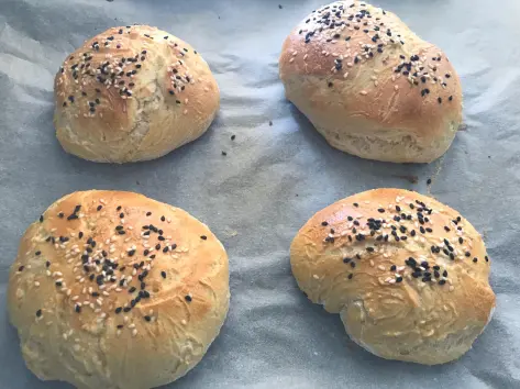
Hoy vamos a hacer tortitas americanas. Perfectas para un buen desayuno, o merienda, o… cualquier hora del día a lo glotón. Que ricas, que ricas.

Ingredientes para 8 tortitas:
En un bol grande tamizamos la harina junto con la levadura, añadimos el azúcar y mezclamos bien.
En otro bol aparte, mezclamos la leche, el huevo y el aroma de vainilla y batimos bien.


Hacemos un volcán en la harina y añadimos la mezcla de líquidos. Lo mezclamos bien con una varilla.
Luego añadimos la mantequilla fundida pero atemperada, que no esté muy caliente y volvemos a batirlo todo muy bien hasta que quede una mezcla homogénea.

Tapamos el bol y lo dejamos reposar al menos una hora en la nevera.
En una sartén o plancha caliente a fuego medio-alto, añadimos una pequeña nuez de mantequilla y echamos una cucharada de mezcla.
Cuando empiece a salirle burbujas, le damos la vuelta, la dejamos como unos 30 segundos más y la sacamos.


Repetimos el proceso hasta que se acabe la masa.
Acompañadas de sirope natural de arce son exquisitas. También les puedes echar chocolate, fruta, nata, helado… En fin, lo que quieras, todo muy sano y poco calórico.

La verdad es que rara vez me quedan redonditas, siempre se me quedan con forma bastante chusquera.
Más fotillas chulas en instagram: https://www.instagram.com/viajando_con_fon/

Hay vamos a hacer un platillo típico coreano: Japchae. Se trata de unos fideos de batata/boniato que están muy, muy buenos.


Ingredientes:
Cortamos la carne en tiras lo más fina posible y la ponemos en un bol junto a las setas shitake, uno de los dientes de ajo picado, 1 cucharada de azúcar, una pizca de pimienta negra molida, 2 cucharadas de salsa de soja y 1 cucharada de aceite de sésamo. Lo mezclamos y lo reservamos en la nevera.

Mientras tanto, batimos el huevo, lo hacemos en la plancha y lo reservamos también.

En una olla grande ponemos agua a fuego fuerte. Cuando empiece a hervir añadimos los fideos. Cuando vuelva a hervir el agua bajamos el fuego a medio-fuerte y cocemos los fideos unos 7 minutos.
Cuando estén cocido los ponemos en una fuente grande, añadimos 1 cucharada de aceite de sésamo, 1 cucharada de salsa de soja y 1 cucharada de azúcar. Lo mezclamos todo bien.
Ponemos 2 cucharadas de aceite vegetal en una sartén y la ponemos al fuego. Salteamos la cebolleta y la cebolla durante unos dos minutos. Añadimos a la fuente.
Salteamos los champiñones con una pizca de sal en la misma sartén. Cuando estén listos los añadimos a la fuente donde tenemos los fideos.


En la misma sartén salteamos durante 30 segundos la zanahoria. Pasados esos 30 segundos añadimos el pimiento rojo, salteamos otros 30 segundos más y lo añadimos a la fuente.
En la misma sartén ponemos la mezcla de la carne con la setas shitake y salteamos unos minutos hasta que la carne esté lista. Lo añadimos a la fuente también.
Entonces añadimos a la fuente el otro diente de ajo picado, 1 cucharada de salsa de soja, 1 cucharada de azúcar, una pizca de pimienta negra molida y 1 cucharada de aceite de sésamo. Lo mezclamos todo muy bien.
Por último añadimos el huevo cortado en tiras y las 2 cucharadas de semillas de sésamo.

Servimos en un cuenco, y listos para degustar.


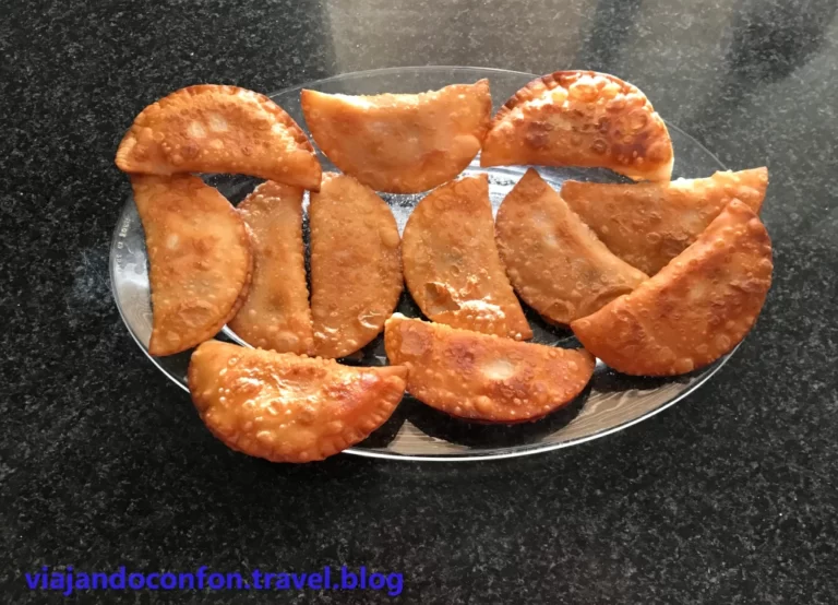
Hoy vamos a hacer Kibinai, unas empanadillas típicas de la ciudad de Trakai en Lituania. Las kibinai tienen su origen en la comunidad caraíta turca que emigraron desde la península de Crimea, cuando ésta formaba parte del Imperio Otomano, a esta zona a finales del siglo XIV.
Son realmente fáciles de hacer y muy sabrosas.
Ingredientes para la masa:
En un bol mezclamos los huevos y la nata.
En una fuente ponemos la harina y añadimos la mantequilla, removemos bien y añadimos la mezcla del huevo y la nata. Mezclamos y amasamos bien hasta que nos quede una masa suave y homogénea.


Tapamos la mezcla con un film trasparente y la reservamos en el frigorífico una media hora.

Ingredientes para el relleno:
En una fuente mezclamos bien todos los ingredientes. Sencillo, ¿no?.

Mientras tanto vamos precalentando el horno a 200ºc.
Sacamos la masa del frigorífico. Hacemos pequeñas bolitas y las aplanamos.


Rellenamos la masa con un poco de carne y la cerramos.

Colocamos las empanadillas en una bandeja de horno sobre papel de hornear y las pintamos con huevo batido.
Bajamos la temperatura del horno a 170º e introducimos las empanadillas.

Horneamos las kibinai entre 20 y 40 minutos (según el tamaño que tengan) y listas para degustar.


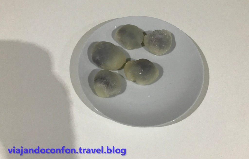
Hoy vamos a hacer auténticos mochis rellenos de anko, la pasta de judías dulce que enloquece a los japoneses.
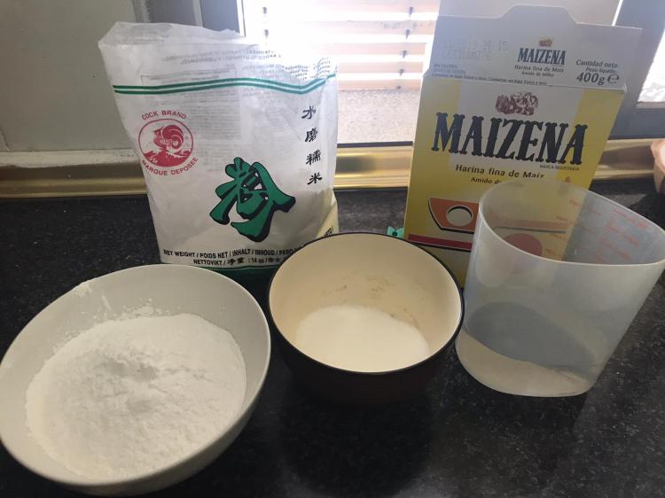
Ingredientes:
La harina de arroz glutinoso es imprescindible y no se puede sustituir por ninguna otra. Se puede encontrar fácilmente en tiendas de alimentación orientales.
Tamizamos la harina en una fuente grande y le mezclamos el azúcar. Una vez mezclado vamos añadiendo el agua poco a poco mientras lo mezclamos con la ayuda de unas varillas hasta que quede una mezcla líquida espesa.
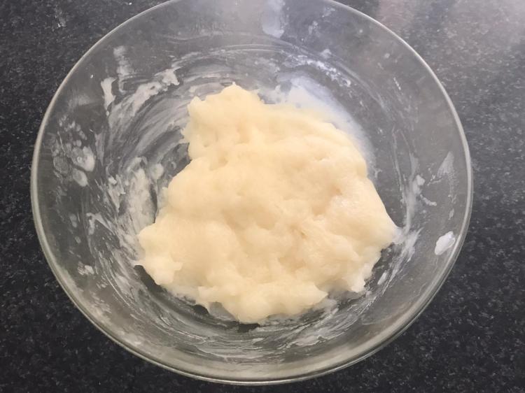
Tapamos el bol con film transparente resistente al microondas y lo metemos durante 2 minutos a máxima potencia en el micro. Lo sacamos y volvemos a revolverlo intentando que no queden grumos.
Una vez mezclado lo volvemos a meter tapado otros dos minutos a máxima potencia en el microondas.
Cuando lo saquemos la masa tiene que brillar para saber que está cocinada y lista para trabajarla.

Con la ayuda de un mortero lo machacamos bien y lo vertemos en una superficie lisa y limpia en la que habremos tamizado un poco de maizena. Con doble cuidado porque quema como un demonio y además es pegajosa como la cola, le vamos dando forma cilíndrica.
Cuando tenga esta forma (más o menos), cortamos en rodajitas y las aplanamos con la ayuda de un rodillo hasta que quede más o menos fina.


Tomamos con una cucharilla un poco de anko y lo envolvemos con cuidado con la masa intentando darle forma redondeada.