On this page you can find general information about the beautiful city of Paris. From its history to learning how to get around.
Content:
Practical Information:
1. Security
France is a safe country. The most touristic areas of the country, especially in Paris, have significant police protection, it is in them, as well as in public transport, where the highest rate of theft occurs, so it is advisable to take a minimum of precautions:
- Do not carry all the documentation, money and cards in the same bag or suitcase.
- Be alert when withdrawing money from an ATM.
- Be discreet when using the mobile in a crowded place.
- Do not leave bags or backpacks unattended.
What if you should avoid some suburbs of big cities like Paris, Marseille or Toulouse. But since they are not touristic areas, they should not be included in our plans.
In the event of loss or theft, whether of objects or documentation, it is advisable to file a complaint at a Police Station: «main courante», if there has been no physical damage, and «plainte» in the event of robbery with aggression.
2. Healthcare
For European citizens, it is recommended that they apply for the European Health Card (TSE). In Spain, it can be requested at any of the Social Security service and information centers or through the Social Security website.
The Card entitles its holder to receive the health benefits that he may need during a temporary stay in France, regardless of the purpose of the stay.
This card entitles you to receive health benefits throughout the French public health network and in many affiliated private establishments, under the same conditions as French Social Security beneficiaries.
In many cases, these conditions include a co-payment system for the medical benefits received and the medicines purchased with a prescription. Specific details can be found here:
https://www.cleiss.fr/particuliers/venir/vacances/index_en.html
For citizens from outside Europe, a good travel insurance is recommended. Healthcare in France is tremendously expensive and, as they say: prevention is better than cure. You can consult them on the IATI website, specialists in travel insurance that, for being our reader, you will get a 5% discount on any of the insurance modalities.
3. Drive in France
The maximum speed on motorways is 130 km/h in normal weather conditions and 110 km/h in case of rain; 80 km/h on bidirectional national highways without central separation and 50 km/h in cities.
Driving with an alcohol level of more than 0.25 mg per liter of expired air, or 0.5 g in blood, is prohibited.
The French administration rigorously enforces traffic legislation, following the «zero tolerance» principle. Thus, a speeding of more than 40 km/h over the authorized limit is sanctioned with the immediate withdrawal of the driving license and a significant fine. In the event that speeding, whatever it may be, puts the lives of third parties at risk, the penalty can be one year in prison and a fine of more than €15,000 ($17,000). The sanction can reach 10 years in prison if there are aggravating circumstances.
3. How to get to Paris
Paris has three international airports and is one of the most visited cities in the world, being one of the ones that receives the most flights.
Charles de Gaulle Airport (CDG)
It is the most important airport in Paris and the second in Europe by number of passengers (after Heathrow in London). More than 76 million travelers passed through its terminals in 2019.
Charles de Gaulle Airport is huge and has 3 terminals. The second of these has different halls connected to each other. To move between the different terminals there is a free bus.
We recommend going long, long before the departure of the flight.
How to get from Charles de Gaulle Airport to Paris.
There are quite a few ways to get to Paris from Charles de Gaulle Airport.
1. Transfer service
It is certainly the most comfortable option but not the cheapest.
For this we recommend the Civitatis service, very good and professional.
2. RER
RER trains on line B connect Charles de Gaulle Airport with the center of Paris in approximately 30 minutes and their frequency is between 10 and 15 minutes.
The price of the ticket is 11.45€ which corresponds to zones 1 to 5. This same ticket will be used to transfer to the Paris metro.
More information on the Paris Airports website.
3. RoissyBus shuttle
The Roissybus is a bus that connects Charles de Gaulle Airport with the Opera square. It takes approximately 60 minutes and the ticket price is 16.20€. The frequency is between 15 and 30 minutes depending on the time slot.

More information on the Paris Airports website.
4. Bus
There are two urban bus lines that arrive in Paris from Charles de Gaulle:
Bus 350: Connects the airport with the Gare de l’Est station.
Bus 351: Connects the airport with Plaza Nation.
The journey takes about 60 minutes and the price is 2.10€. The frequency is between 15 and 35 minutes.
Hours are from 5:30 a.m. to 9:30 p.m.
If you arrive after 9:30 p.m., you can take one of the two night bus routes (Noctilien) that connect Charles de Gaulle with Gare de l’Est station. The lines are 140 and 143 and their price is 8€.
5. Taxi
The taxi between Charles de Gaulle Airport is between 50€ and 70€, depending on the destination.
Go to the downtown area on the right bank of the Seine River, where, for example, the Pompidou Center is located, the price is closed and it is €53.
Go to the central area of the left bank of the river, where the Eiffel Tower is located, the price is also closed and is €58.
6. Go to Disneyland Paris
If your destination is Disneyland, the most direct way to get there is by taking the Disneyland Magical Shuttle from €23 with a duration of approximately 45 minutes.
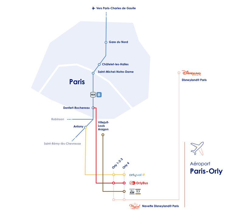
Transfer between Charles de Gaulle Airport and Paris Orly Airport
If your flight arrives at Charles de Gaulle Airport and your connection departs from Paris Orly airport, you can take the RER B train to Antony and transfer to the Orlyval light rail there.
The frequency is between 4 and 7 minutes and the journey takes about 30 minutes. The train work between 6 am and 11:35 pm. The price of RER+Orlyval tickets is €12.10.

Paris Orly Airport
Orly (ORY) is the second largest airport in Paris after Charles de Gaulle. In 2018, more than 32 million passengers passed through its terminals. It has two terminals: South and West. If you want to move between both terminals you can do it for free on the Orlyval automatic train.
How to get to Paris from Orly
1. Transfer service
It is certainly the most comfortable option but not the cheapest.
For this we recommend the Civitatis service, very good and professional.

2. Orlyval and RER B
The Orlyval automatic train connects Orly Airport with the Antony RER station, where we can take line B.
The frequency is between 3 and 7 minutes, and the journey takes about 30 minutes. The price is 14.10€.
More information on the Paris Airports website.
3. Tram
Tram line 7 connects Villejuif-Louis Aragon metro station (terminus of Paris metro line 7) with Athis-Mons via Orly 4. The line passes through Paris-Orly airport with a stop at Orly 4 and the Coeur d’Orly area (Ibis, Ibis Budget and Novotel hotels).
The journey takes about 45 minutes to/from the Villejuif-Louis Aragon metro stop and the frequency is between 8 and 15 minutes. It works from 5.30 to 00.30. The price is 2.10€.

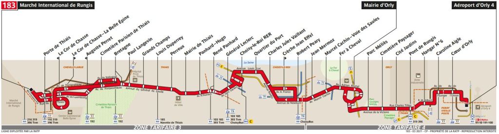
Tram line 9 connects the Porte de Choisy metro station (Paris metro line 7) with Orly Ville. It connects the Paris-Orly airport with the 183 bus.
The journey takes 1 hour to Orly airport, it works from 05:30 to 00:30. The price is €1.90.

Bus 183 provides access to Paris-Orly and the Rungis international market. Its route allows a connection on the T7 tramway (“Bretagne” stop), the T9 tramway (at “Choisy-le-Roi RER” and “Robert Peary”) as well as the RER C (at “Pont de Rungis – Aéroport d’ Orly” and “Choisy-le-Roi RER”).
More information on the Paris Airports website.
4. Orlybus
This is a shuttle bus service between Paris-Orly airport and Place Denfert-Rochereau.
The journey takes about 30 minutes with a frequency between 10 and 15 minutes. The Orlybus runs from 05:35 to 00:30. The ticket price is 11.20€.

More information on the Paris Airports website.
5. Taxi
The price of a taxi from Orly Airport to the center of Paris is between €70 and €80.
Beauvais Airport
Beauvais Airport, 85 km north of Paris is a small airport in Tillé, a small town located near Beauvais. Beauvais is the airport where low cost airlines.
How to get to Paris from Beauvais airport
1. Transfer service
It is certainly the most comfortable option but not the cheapest.
For this we recommend the Civitatis service, very good and professional.
2. Bus
Paris-Beauvais Airport offers a regular direct bus service between central Paris at Porte Maillot station and the airport.
The journey takes about 75 minutes and the price is 16.90€ (one way). The return ticket price is 29.90€
To return from Paris to the airport, buses leave 3 hours before the flight from the bus park on Boulevard Pershingla next to Porte Maillot station.
3. Taxi
It is not a recommended transport due to its high cost, between 170€ and 210€.
More information on the Paris-Beauvais Airport website.
4. Transport in Paris
1. Metro
The first line of the Paris metro was inaugurated on July 19, 1900 and connected Porte de Vincennes with Porte Maillot. Since its inauguration, the network has been gradually expanding, having opened the last line in 1998, which is considered one of the most modern in the world. Today it has 303 stations and 219 kilometers of tracks.
It is the third longest metro network in Western Europe, only surpassed by London and Madrid.
The metro is the fastest way to get around Paris. The metro network consists of 16 lines that communicate with each other and with the RER trains.
The hours are from 5.30 to 1.00.
There are several types of transport ticket: single ticket, called Ticket t+, and daily and weekly passes, Paris Visite and Passe Navigo. We will analyze these below.
More information on the Paris transport website.
2. Bus
The most popular transportation system after the subway. Paris has more than 60 lines and 40 night lines.
The advantage over the metro is that you see Paris during the journey. The downside is that, as long as you get stuck, you don’t get to the destination in life.
Night buses (Noctilien).
Noctilien buses are night buses that run between 00:30 and 07:00. The frequency of these buses is from 10 to 15 minutes on weekends and from 15 to 30 minutes on weekdays. They are identified by having the letter N before the number.
There are several types of transport ticket: single ticket, called Ticket t+, and daily and weekly passes, Paris Visite and Passe Navigo.
It is advisable to buy tickets in advance at metro stations, newsagents and tobacconists. If we buy them from the driver, it carries an extra fee of €0.40.
More information on the Paris transport website.
3. Tram
It worked until 1957, the year in which it was completely replaced by the metro, but at the end of the 20th century, the RATP company put it back into operation.
There are currently 9 tram lines in operation, although they are of little use to tourists.
More information on the Paris transport website.
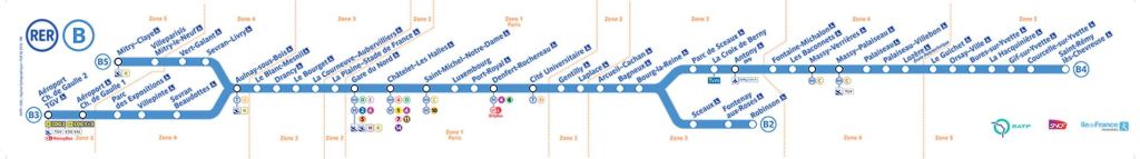
4. RER
The RER trains in Paris are regional trains that, in addition to reaching nearby places, complement the metro network when they run through the city center.
The Paris suburban network has five lines, more than 250 stations and almost 600 kilometers of track. The RER lines are named with letters: A, B, C, D and E. The most interesting from a tourist point of view are the first three.
RER A: Connects Disneyland Paris with the city center.
RER B: Connects Charles de Gaulle Airport with the center of Paris.
RER C: Arrives at Orly Airport and the Château de Versailles.
The lines have normal and express trains. The express do not stop at all stations so you have to take this into account and look carefully at the station screens. In these we also have to look at the destinations since they vary according to the hours on the same lines.
More information on the Paris transport website.
5. Funicular at Montmartre
The Montmartre Funicular connects the lower part of the Montmartre neighborhood with its upper part, where the Basilica of the Sacred Heart is located.
The Montmartre Funicular became operational in the summer of 1900 and was then hydraulically powered using a system of cisterns that filled and emptied according to passenger load. It has undergone several renovations until reaching the current one, from 1991.
Its hours are from 6:00 to 00:45. There are several types of transport ticket: single ticket, called Ticket t+, and daily and weekly passes, Paris Visite and Passe Navigo.
6. Batobus
The Batobus is a tourist boat that runs along the Seine river making stops at the main points of interest in Paris.
As with tourist buses, at each stop you can stop as long as you want and wait for the next boats.
The schedule in summer is from 10:00 to 19:00 and in winter from 10:00 to 17:00 and its frequency is 30 minutes in summer and 45 in winter.
Here you can buy your tickets in advance:

7. Tourist bus
All tour bus companies offer open-top, double-decker buses with Spanish commentary via headphones.
We recommend Paris Big Bus (formerly Les Cars Rouges), the oldest tourist bus company in Paris. As its old name indicated, Big Bus Paris buses are red.
The Big Bus Paris itinerary has a total duration of 2:15 hours and makes 11 stops, allowing you to get on and off at each of them.
The Big Bus operates from 9:30 a.m. to 8:15 p.m. and its frequency ranges between 10 and 20 minutes, depending on the time of year.
Here you can easily buy tickets in advance:

8. Taxi
Taxis in Paris are normal cars and the only thing that identifies them is the sign on the roof. Inside they must have a taximeter and a plate indicating the license number.
The minimum service has a cost of €7 so, unless you run out of transport at dawn, it will not be worth using it.
9. Tickets
Ticket t+
Ticket t+ is the name by which the single ticket for the Paris transport network is known. This ticket allows the use of the main means of transport for 90 minutes (except Orlyval, Roissybus, buses 299, 350, 351 and Noctiliens and Tram Express 11).
It comes in the form of a cardboard ticket or loaded onto a contactless medium.
The t+ Ticket does not allow you to go / return on the same line, or interrupt the trip and then continue on the same line.
The price is 2.10€. The 10-trip t+ Ticket costs €16.90.
Passe Navigo
The Passe Navigo is the most used transport pass by the inhabitants of Paris and is the cheapest way to get around the city for long stays.
We have the Passe Navigo Semaine, which is valid for the whole week and has several inconvenients:
| ZONE | WEEK PRICE | MONTH PRICE |
| Zone 1-5 | 30€ | 84.10€ |
| Zone 2-3 | 27.45€ | 76.70€ |
| Zone 3-4 | 26.60€ | 74.70€ |
| Zone 4-5 | 26.10€ | 72.90€ |
The Passe Navigo can be purchased at Metro stations, RER stations and at airports.
There is also the Passe Navigo Jour, valid for one day with unlimited travel.
| ZONE | PRICE |
| Zone 1-2, 2-3, 3-4, 4-5 | 8.45€ |
| Zone 1-3, 2-4, 3-5 | 11.30€ |
| Zone 1-4, 2-5 | 14€ |
| Zone 1-5 | 20.10€ |
Your Navigo Jour pass is valid for unlimited travel in certain areas of the Île-de-France network. Keep in mind that the Navigo Jour pass does not have any zoning.
To choose the zones of your pass, just take into account the zones of your starting point and your arrival point. For example, if you are looking for a pass to go from Aulnay-Sous-Bois (zone 4) to Evry (zone 5), buy an «all zones» pass, since you have to go through Paris.
Mobilis Pass
The Mobilis Pass is valid for a full day from midnight to midnight the following day.
The Mobilis pass is personal: do not forget to write your name, surnames and date of use on the coupon so that it is valid.
The prices are exactly the same as the Navigo Jours Pass.
Paris Visite Pass
The Paris Visite card allows the traveler unlimited use of the Metro, Bus, RER, Tramway, Orlyval, Montmartrobus, Noctilien and Funicular de Montmartre and, in addition, small discounts are obtained in some attractions, among others, the Opera, the cruise the Seine or the tourist bus.
The Paris Visite card is available in periods of 1, 2, 3 and 5 days. For the calculation of days, full days are counted, so the first day is counted when we use it for the first time, regardless of the time.
It must be completed with your last name, first name and date of use in order to use it and, of course, it must be validated before any trip.
| VALIDITY | 1 DAY | 2 DAYS | 3 DAYS | 5 DAYS |
| Zone 1-3 | 13.55€ | 22.05€ | 30.10€ | 43.30€ |
| Zone 1-5 | 28.50€ | 43.30€ | 60.70€ | 74.30€ |
The Paris Visite pass is considerably more expensive than the Navigo, so it is not recommended, especially for passes of more than one day.