Los primeros pobladores fueron los baltos o aesti, entre cuyas tribus se incluían también los prusianos originales y los letones. Fueron una etnia de origen indoeuropeo única, fuertemente influidas por los germanos. Pero también tuvieron lazos comerciales con el Imperio romano. Las primeras referencias conocidas sobre Lituania como nación (Litua) provienen de los anales del monasterio de Quedlinburg. Están fechados el 19 de febrero de 1009.
El territorio que actualmente corresponde a Lituania se remonta al siglo XIII como Estado medieval. Fue primero un gran ducado independiente.
Se considera que la fecha de la constitución del primer Estado lituano fue la coronación oficial de Mindaugas. Fue el 6 de julio de 1253 en Vilna. Unió a los duques lituanos rivales en un único Estado.
Durante el siglo XIII el reino fue invadido varias veces por los reyes mongoles de la Horda de Oro. Los mongoles fueron derrotados en 1377 en «Aguas Azules». En 1385 se unió a Polonia tras la coronación como rey de Vladislao II Jogaila.
Encuentra las mejores actividades y tours en Lituania con Civitatis:
*Nos ayuda a mantener el blog
En 1401 Vitautas, primo de Jogaila, se proclamó Gran Duque de Lituania y se disolvió la unión de los dos países. Gracias a la cooperación de ambos países, los ejércitos lituano y polaco vencieron a la Orden Teutónica en la batalla de Grunwald en 1410. Fue la mayor batalla en suelo europeo librada en todo el siglo XV.
Más tarde Polonia se la anexionó de nuevo. Formaron la República de las Dos Naciones en virtud de la unión dinástica de los dos estados en 1569. Convirtiéndose así en el país más grande de Europa. Según el sistema de unión de los dos países, Lituania pudo conservar un auto-gobierno.
Posteriormente se incorporó a Rusia en 1795 bajo el reinado de Catalina II de Rusia.Fue tras un proceso de desintegración que duró todo el siglo XVIII (particiones de Polonia).
A finales del siglo XVIII y hasta el comienzo de la Primera Guerra Mundial, Lituania recobró su autonomía. Aunque siguió formando parte del Imperio ruso. La represión de los gobernantes rusos contra el pueblo y la cultura lituanas provocó dos grandes revueltas en 1836 y 1863.
Tras el Levantamiento de Enero de 1863, fueron prohibidos los libros, periódicos y la enseñanza en general en idioma lituano durante los siguientes 40 años. Con el fin de ejercer un mayor control, las autoridades rusas sustituyeron el alfabeto latino del lituano por el alfabeto cirílico.
Durante la Primera Guerra Mundial, entre 1914 y 1918, Lituania estuvo ocupada por Alemania. Declarando otra vez su independencia el 16 de febrero de 1918.
Entre 1918 y 1921 libró una guerra contra la recién proclamada República de Polonia. Esta había intentado anexionarse el Estado Lituano. La guerra se saldó con la pérdida del 20 % del territorio lituano. Con la capital Vilna incluida, por lo que la capital se trasladó provisionalmente a Kaunas.
Encuentra tu hotel ideal al mejor precio en Lituania con Agoda.
*Nos ayuda a mantener el blog
en junio de 1940 las tropas de la Unión de Repúblicas Socialistas Soviéticas (URSS) ocuparon el país, y en agosto de ese año Lituania fue anexionada, convirtiéndose en la República Socialista Soviética de Lituania; pero desde 1941 y hasta 1944 la Alemania Nazi expulsó al Ejército Rojo, por lo que una parte de la sociedad lituana percibió a los alemanes como sus libertadores frente al imperialismo bolchevique. Tras la victoria militar del Ejército Rojo y las tropas aliadas, sobre el ejército nazi, Lituania pasó a formar parte de la Unión Soviética, tras haberse acordado en el tratado de Potsdam de 1945.
En 1988 se formó el Movimiento Lituano por la Sąjūdis, que triunfó en las elecciones de 1989 en el Seima lituano, todavía perteneciendo Lituania a la Unión Soviética. En 1990 Vytautas Landsbergis fue elegido presidente, proclamando la independencia de Lituania el 11 de marzo de 1990, apoyado por la llamada Revolución Cantada. Aunque esta independencia no fue reconocida internacionalmente hasta 1991.
Como siempre, recomendamos viajar con un buen seguro de viajes. IATI es especialista en seguros de viaje y, por ser nuestro lector, tienes un 5% de descuento.
Eating in Iceland is not cheap, leaving the Pylsur (hot dogs) or large supermarkets, the economic effort is quite large.
Here we are going to list the places where we ate throughout the country, to try to spend “little” and eat well.
Several times we ate at the KFC franchise, which is safe and is the cheapest, but not the best. A bucket of chicken for two people is around 4,799 ISK (€33). If you like McDonald or Burger King, forget it, in Iceland there are none.
Something that surprised us about Iceland is that all the restaurants we visited have vegan options, even fast food franchises.
1. Reykjavik Fish
To eat a good fish & chips and try a delicious traditional Plokkari. They also have fish soup and some burgers.
They have a fairly small menu, making the choice easy.
There are two places in the city, one at Tryggvagata 8 and the other at Frakkastígur 12. You can eat for around 3.390 ISK (€23) per person.
Restaurant located in the tourist complex of Geysir, in the Golden Circle. Quite a variety of food at a very good price. Most of it located in hot beds from which they serve you directly.
Everything was very rich.
Price from between €15 and €20 per person.
Meat balls
knuckle of lamb
Adress: 8M5X+Q44, 806, Iceland.
5. Halldórskaffi
Small restaurant in Vík í Mýrdal with some traditional Icelandic dishes, as well as burgers, sandwiches and, special mention, cakes. Very cozy atmosphere, with very good service and very reasonable price. From about 3.200 ISK (€22) per person.
At the entrance to the city of Hólmavík, there is a supermarket from the Krambúðin chain. Next to it is this restaurant-cafeteria called Veitingasala, which offers pylsur, hamburgers and little else.
Simple and quite cheap. There’s nothing wrong.
Price from around €15 per person.
Adress: Höfðatún 4 510, 510 Hólmavík, Iceland.
9. Edinborg Bistro
Nice restaurant-pub in Ísafjörður that offers fish of the day, some pasta and meat. It’s not cheap but it’s really good.
Price around 4.500 ISK (€31) per person.
Adress: Aðalstræti 7, 400 Ísafjörður, Iceland.
Discover the best activities and tours in Iceland with Civitatis:
10. Dalakot
It is a pizza-burger restaurant located in the city of Búðardalur, at the exit of the Westfjords. Great pizzas and delicious salads. They also have meat dishes.
Very good service and reasonable prices.
Prices from €12 for the cheapest hamburger to €22 for the lamb dish.
Located in the city of Grundarfjörður, a small and cozy place where they serve pizzas, pasta and some traditional dishes. Do not persecute the plokkari.
Price: about €20/23 per person.
Adress: Nesvegur, 350 Grundarfjörður, Iceland.
12. Agnið streetfood
A small food truck located in the car park of the Snæfellsnes Visitor Center. Tasty burgers and great sandwiches. And at a great price; about €15 per person.
Adress: Breiðabliki, 342 Stykkishólmur, Iceland.
Extras
If you want to eat even cheaper, you will always have supermarkets. The cheapest are the Bónus and Krónan.
You will find both throughout the Icelandic geography.
Here we leave you a map with the restaurants in which we ate those days:
Find the best hotels in Iceland at the best price with Agoda:
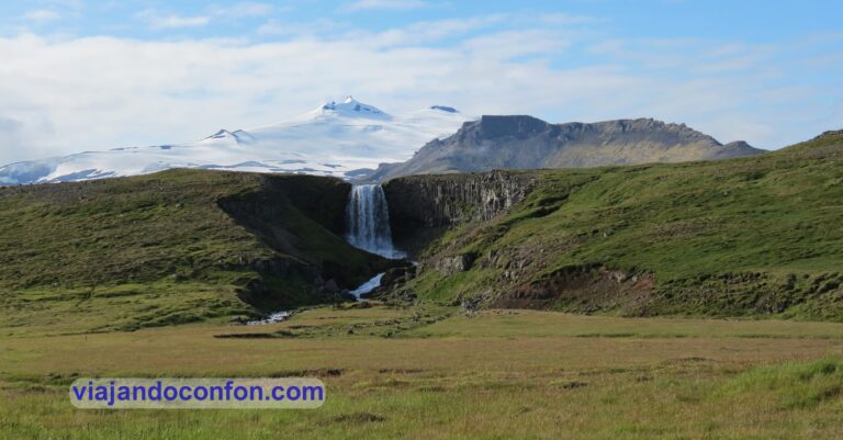
Öxarárfoss is a small waterfall about 14 meters high. Of course, it does not impress due to its size, but the setting in which it is located is really beautiful.
The Icelandic writer Björn Th. Björnsson wrote:
“Although Öxarárfoss is not large in size, it is peculiarly beautiful and has a lot to do with it. It falls from a smooth edge and is reasonably wide to give it particularly graceful proportions. The boulders are below, but not covering, creating a lot of spray. But this is how the sun behaves here, in the last part of the day it stands obliquely along the gap and shines on the waterfall, so rare to see. The surroundings created by the crack hammers do not in the least enhance the beauty, whether the waterfall is in light mode in summer or in icy bands in winter.”
How to get there: Öxarárfoss is located 52km from Reykjavik.
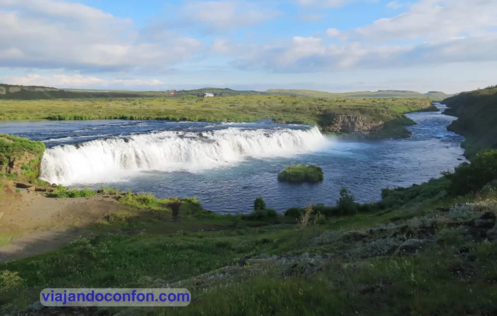
09. Goðafoss
Goðafoss Waterfall is located on the Skjálfandafljót River, the fourth largest river in Iceland. It is one of the most spectacular waterfalls in the country, falling from a height of 12 meters over a width of 30 meters.
The name Goðafoss means waterfall of the gods or waterfall of the ‘goði’ (priest) and comes from a fascinating story:
When Iceland was established between the 9th and 10th centuries, the majority of the population were Norwegian descendants who followed the Old Norse religion and worshiped deities such as Thor, Odin, Loki and Freya.
In 930, after establishing the Commonwealth, the pressure for its Christianization began. Around the year 1000, Norway threatens an invasion if they continue to maintain their pagan religion. This is discussed in Þingvellir where Þorgeir Ljósvetningagoði, the priest Ásatrú (or goði) and spokesman for the law, is given the responsibility of making the decision.
He spends a day and a night reflecting and praying to the gods for the right decision. He finally communicates that, for the people’s sake, Christianity would be the official religion, but pagans could practice the Norse religion in private.
To symbolize his decision, he returned to his home in northern Iceland and cast idols of the old gods into a beautiful waterfall. Since then, it would be known as Goðafoss.
How to get there: Goðafoss is located 422km from Reykjavik and 34km from Akureyri.
08. Skógafoss
Skógafoss is located in the course of the Skógá river and has a height of 60 meters and a width of 25.
According to legend, the first Viking settler in the area, Þrasi Þórólfsson, hid a treasure in a cavern behind the waterfall.
From one side of the waterfall there are some stairs with a few steps: 400! Here we find a platform to see the waterfall from above. There are also spectacular views of the entire area.
On the eastern side of the waterfall, a hiking trail leads to the Fimmvörðuháls pass between the Eyjafjallajökull and Mýrdalsjökull glaciers. Then it goes down to Þórsmörk on the other side and continues like the famous Laugavegur to Landmannalaugar.
How to get there: Skógafoss is located 156km from Reykjavik.
If you want to be on the safe side, you can book a fabulous tour with Civitatis:
07. Svöðufoss
Svöðufoss is a beautiful 10-meter-high waterfall that pours between basalt columns into the Hólmkelsá River.
The setting in which it is located is truly spectacular, with the watchful summit of the Snæfellsjökull volcano with its glaciers.
Snæfellsjökull is a stratovolcano 700,000 years old and 1,446 meters high. The mountain is actually called ‘Snæfell’ (Snow Mountain), although ‘jökull’ (Glacier) is often added to help distinguish it from other mountains of the same name.
In August 2012, it ran out of snow for the first time in its history. Fact that generated concern among the locals that climate change threatens the nature of the mountain.
How to get there: Svöðufoss is located 200km from Reykjavik and 43km from Arnarstapi.
06.Dynjandi
Dynjandi is the largest waterfall in the Westfjords. It is located near the bay of Dynjandisvogur and the fjord Arnarfjörður.
Dynjandi is known as the “Bridal Veil” for its resemblance to this garment. It has a 100-meter drop and is 30 meters wide at the top and 60 at the base.
The walk from the car park to Dynjandi is approx 200m uphill with some steps.
How to get there: Dynjandi is located 361km from Reykjavik and 59km from Ísafjörður.
05. Dettifoss
Located in the Jökulsárgljúfur National Park, it is a spectacular waterfall 100 meters wide and 44 meters down. With a flow of between 200 and 500 m³ per second, it is the mightiest waterfall in all of Europe.
Nearby is the Selfoss waterfall. Smaller than its neighbour, it is a beautiful waterfall that flows wide down the basalt columns that surround the Jökulsá á Fjöllum river.
How to get there: Dettifoss is located 520km from Reykjavik, 133km from Akureyri and 161 from Egilsstaðir.
04. Gullfoss
Gullfoss (Icelandic for Golden Waterfall) is the most famous waterfall in Iceland. Nestled in the Hvitá river canyon, it has two waterfalls, one 11 meters and the other 21. In total there are 32 meters of fall and a flow of between 80 and 140 cubic meters of water per second.
Next to the stairs that go up to the visitor center we find a small monument dedicated to Sigríður Tómasdóttir. She was an Icelandic environmentalist whose activism helped preserve the Gullfoss waterfalls, protecting them from industrialization. She is considered Iceland’s first ecologist.
A piece of advice: take a raincoat with you because if you go near the waterfall you will end up soaked.
How to get there: Gulfoss is located 116km from Reykjavik.
Find the best hotels in Iceland at the best price with Agoda:
*It helps us to maintain the blog
03.Brúarárfoss
Brúarárfoss, a small but beautiful waterfall on the Brúarà river. It is neither the largest nor the mightiest in Iceland, but its turquoise waters are truly hypnotic.
From the car park you have to do a little trekking of about 3 km following the Brúarà river to reach the waterfall.
It is a relatively smooth path, although the day we were there it was extremely muddy and it was somewhat difficult to walk. In some sections it was literally impossible to walk and you had to go a little off the road.
Brúara River
Trail to Brúarárfoss
Brúarárfoss is not the only waterfall on the way. We are going to find two more. The first is Hlauptungufoss, approximately 1.5 km from the car park.
Here we can already appreciate the incredible turquoise color of the water from the melting of the glaciers.
Hlauptungufoss
A little further on we come across the second: Miðfoss. As its name indicates, it is the one in the middle…
Miðfoss
And now yes. At about 800 meters we find the spectacular Brúarárfoss. Judge for yourself. Although I have to say that the photos do not do justice to the color of the water.
Brúarárfoss
The truth is that it is well worth the walk and having gotten into the mud up to our ankles.
How to get there: The Brúarárfoss car park is located 91km from Reykjavik. From here you have to walk about 3 km along a very easy path.
02. Svartifoss
Svartifoss is a spectacular waterfall located to the south of the Vatnajökull glacier.
Svartifoss is one of the famous waterfalls in Iceland. It is not because of its height (20 m) or because of its flow. It is because of the spectacular setting in which it is located. It is surrounded by hexagonal basalt columns. These basalt columns have inspired Icelandic architects, such as the Hallgrímskirkja church in Reykjavík.
From the visitor center we must walk about 2 km to the waterfall. Shortly before halfway we come across Hundafoss, a 25 m high waterfall.
Its name is derived from the Icelandic word “hundur”, which means dog. The name comes from the fact that, during the flooding of the river, sometimes the dogs from the farms would float out of the waterfall.
Hundafoss
How to get there: The Svartifoss car park is located 327km from Reykjavik, 141km from Vík í Mýrdal and 137km from Höfn. From the visitor center you have to walk about 2 km uphill
Discover the best activities and tours in Iceland with Civitatis:
*It helps us to maintain the blog
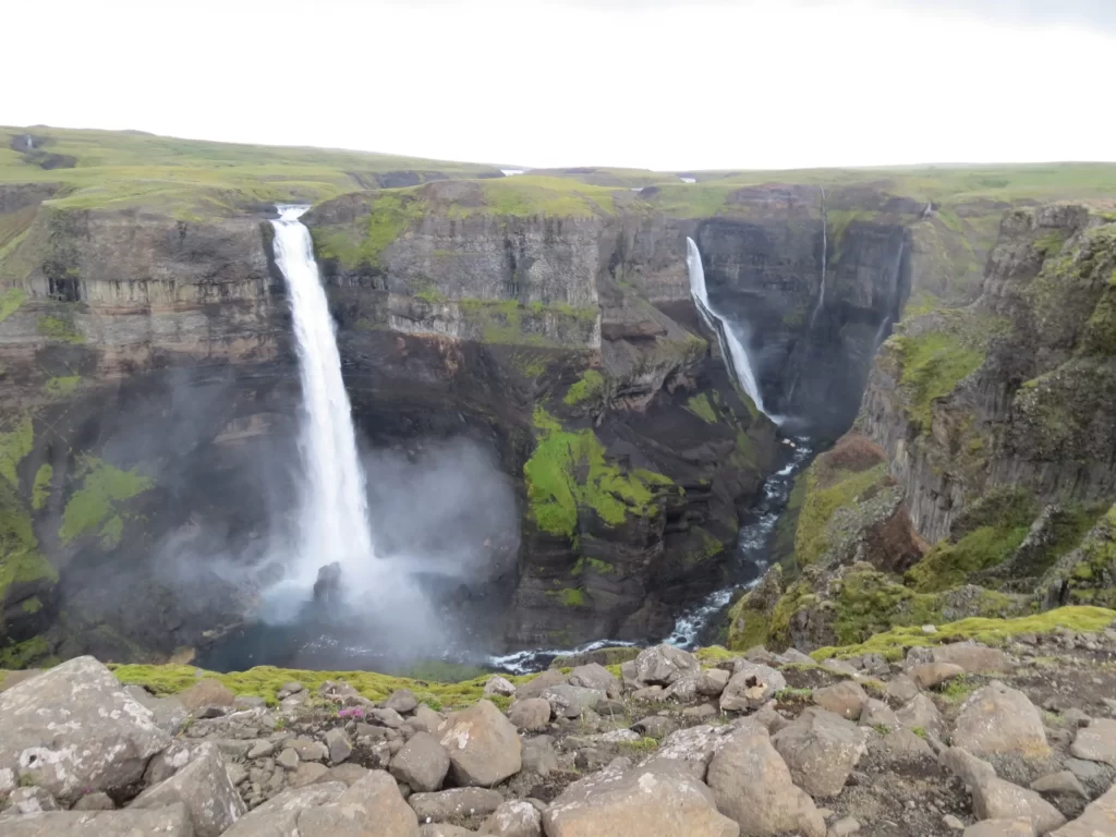
01.Háifoss
Háifoss was theoretically the highest waterfall in Iceland. The Fossá River pours its waters here at no less than 122 meters high. Recent measurements indicate that Hengifoss is the highest waterfall on the island at 128 metres.
Next to Háifoss is another large waterfall called Granni. The whole set forms an authentic spectacle of nature.
Háifoss
Granni
How to get there: The Háifoss car park is located 140km from Reykjavik.
Here we leave a map with the situation of the waterfalls in Iceland:
Discover more about Iceland through our travel diary.
We continue our journey through Iceland and arrive at the capital: Reykjavik. It is coming to an end (unfortunately). We leave the Snaefellsnes peninsula behind and head to what will be our hotel for the last two nights.
We chose the Laxness Hotel, a simple hotel located in the town of Mosfellsbær, about 15 km north of Reykjavik. It cost us €120 per night with a private bathroom.
Find the best hotels in Iceland at the best price with Agoda:
July 23rd
Since we still had some time, we left our things at the hotel and went for a walk around the nearby Mount Esja.
Mount Esja, located in Kjalarnes, is one of the most popular destinations in Iceland for day trips. Actually, Esja is not a mountain itself, but a volcanic chain, whose highest peak reaches 914 meters in height.
Mount Esja
The way up the mountain is divided into different sections, with signs indicating the difficulty of each route.
The best known paths lead to the summits of Þverfellshorn (780 m) and Kerhólakambur (851 m). The highest point is called Hábunga and requires an additional three kilometer hike northeast of Þverfellshorn.
Approximately 200 m from the top, hikers find themselves on a large rock called Steinn. There they can choose three options: continue on the marked path, go directly to the top or simply enjoy the excellent views before descending. Climbing to the top is recommended only for experienced hikers.
The truth is that we, already exhausted from so many days and, above all from such a fascinating day, soon decided to turn around.
We got back in the car and went to the hotel.
For dinner we do not complicate life much. Right in front of the hotel there was a restaurant from the KFC chain and we had dinner right there. The truth is that it is much more expensive than in Spain. 4,087 ISK (€30) we got dinner.
July 24th
We get up very early and we set out. At 12:00 we have to return the car and we had to take advantage of it.
We are going to try to do the hiking route that runs through the Geldingadalir volcano area again, which we had to cancel the first attempt due to inclement weather.
But today yes. We arrived at the car park (number 1, there are 3) and it was hardly windy and not very cold.
There are several routes up according to the difficulty. They are well signposted with the letters A, B and C. The A is about 3 km long and is the easiest.
The B is a little longer, about 3.5 km and is more difficult. When we were there it was cut off.
The C has two variants. By Langihryggur it is about 4 km. By Nátthagi it is 2 km and it is the easiest. In this one you can see the lava field but not the crater.
We did the A. At first the route is very beautiful, admiring the beautiful landscape of Reykjanes.
We started to climb uphill until we reached one of the edges of the still smoking lava field.
We continue up the even steeper path until we reach the top, from where we have a fascinating view of the lava field and the crater.
Geldingadalir Crater
How to imagine that just a few days later, the ground would reopen in this area.
It was starting to get late to return the car, we decided to run to the rental office. We return it and take a walk to the bus stop to go to Reykjavik.
We arrive at the stop. WOW! It takes a long time for it to happen. We looked for somewhere to eat or buy something that the stomach began to complain. There was practically nothing open around but we did find a pylsur stall in front of the town hall. It’s called Pulsuvagninn and it was good… along the lines: cheap and tasty.
The bus arrives on time and the driver turned out to be the same horny one from the first day at the airport (it’s the same line). We did not hesitate and we got behind him. Laughing all the way once again.
Reykjavik
Reykjavik is the capital of Iceland and its most populous city with almost 138,000 inhabitants and some 245,000 including its metropolitan area.
According to what is said in Landnámabók, Ingólfur Arnarson was the first settler of Iceland. He settled in the year 870 where the city stands today and named his hut Reykja (r) vík. Recent archaeological excavations in the area of Aðalstræti, Suðurgatu and Kirkjustræti seem to corroborate this.
Ingólfur Arnarson
We got off the bus next to the BSI station, which is the station of the direct airport bus company, not the public one.
If you want more comfort, discover the Civitatis Reykjavik City Tour:
From here we went for a walk to Hallgrímskirkja, about 15 minutes walk.
Hallgrímskirkja is a Lutheran church located on top of the Skólavörðuhæð hill. And although many think so, it is not a cathedral, it is a “simple” church.
Almost 75 meters high, from its bell tower you get spectacular views of the entire city.
It was built between 1945 and 1986 according to the design of the architect Guðjón Samúelsson, who wanted to capture the spectacular Icelandic nature in the building. For this he was inspired by glaciers, mountains and lava formations, particularly the hexagonal basalt columns that surround the Svartifoss waterfall in Vatnajökull National Park.
It’s also designed to resemble Thor’s hammer, with the handle upturned, as a nod to Iceland’s religious history.
The interior is quite austere. A really simple decoration, highlighting the organ with more than 5,000 pipes built by the German company Johannes Klais from Bonn and installed in 1992.
Outside we find a statue of Leifur Eiríksson, the Nordic explorer who discovered North America 500 years before the arrival of Christopher Columbus. The sculpture is the work of American sculptor Alexander Stirling Calder and was a gift from his government to Iceland in 1930, to commemorate the millennium of the Alþingi, the world’s first democratically elected parliament founded in 930 in Þingvellir.
It was already time to eat seriously so it was time to find a place. We go down towards the center along Skólavörðustígur street. On the way we bought some souvenirs. Almost at the end of the street, it becomes pedestrian and is renamed Regnbogagatan (Rainbow Street).
The floor of Regnbogagatan is painted in the colors of the rainbow representing the kindness and acceptance of Iceland towards its LGTBI community. Iceland is considered one of the friendliest countries with the LGTBI collective in the world.
There was a place here called Reykjavik Fish. Basically Fish & Chips and little else. It was quite good and not expensive: 5,670 ISK (€40).
After eating we went for a short walk through Laugavegur, one of the main shopping streets of the city. In it we can find hundreds of restaurants, clothing stores, souvenirs, etc…
Walking quietly we arrived at Laekjargata, another of the main streets of the city. Here we can find Stjórnarráðshúsið, the office of the Prime Minister of Iceland. The building was originally built as the first penitentiary in Iceland.
On March 20, 1759, King Frederick V of Denmark ordered the construction of a prison in Iceland. It was built between 1761 and 1771 and they used some convicts as labor.
In 1816 it stopped working as a prison and in 1904 reforms began to be the government building. In 1918 it began to function as a government building.
Stjórnarráðshúsið
Nearby is Safnahúsið (house of culture), which is part of the National Gallery. The building was built between 1906 and 1908 by the Danish architect Johannes Magdahl Nielsen.
In 1908 the museum of antiquities was moved here until 1950 it was moved to its own building in 1950. Between 1908 and 1947 you could also find the Museum of Natural History of Iceland.
In 1909 the National Library and the National Archives were moved. The first until 1994 and the second until 1987.
Currently in the building is the permanent exhibition Points of View and temporary exhibitions.
We continue down to Austurstræti, another of the main shopping streets of the city. In it we can find some of the oldest buildings in the city.
Parallel to Austurstræti we find the Austurvöllur square. It is one of the most popular places to meet. Good for sunbathing, for coffee or for mass protests, since the Alþingi, the Icelandic Parliament, is located here.
In the square there are several noteworthy elements, such as the aforementioned Alþingi. As we already mentioned in the first journal entry, the Alþingi was formed in 930 AD, originally in the Þingvellir National Park.
In 1800, the Alþingi was temporarily dissolved by the Danish King Christian VII and replaced by a High Court in Reykjavík. In 1843 the parliament was re-established through a second royal decree.
Since then, the Alþingi has been modernized with the times. The right to vote grew to incorporate everyone, regardless of income and gender, and eventually, first by achieving Home Rule and then Independence from Denmark.
Alþingishúsið (Parliament House)
The current building, known as Alþingishúsið (Parliament House), opened in 1881 and is the work of Danish architect Ferdinand Meldahl. The Alþingishúsið was also the home of the National Library, until 1908, and of the National Gallery of Iceland, until 1950. The University of Iceland operated on the first floor of the building between 1911 and 1940, and the President of Iceland had his offices there. until 1973.
Returning to Austurvöllur square, we can find in the center a statue of Jón Sigurðsson, the leader of the Icelandic independence movement. That during our visit it was found covered by scaffolding.
In the square is also Svarta keilan – Minnisvarði um borgaralega óhlýðni (The Black Cone, Monument to Civil Disobedience). It was created by the Spanish Santiago Sierra and installed in 2012 to honor the protests that took place here after the economic crisis of 2008.
It is a large stone with a black metal cone embedded in it and a plaque written in Icelandic and English. In it you can read the Declaration of the Rights of Man and of the Citizen of 1793:
“When the government violates the rights of the people, the insurrection is for the people and each part of the people the most sacred of rights and the most indispensable of duties.”
Next to Alþingishúsið is Dómkirkjan í Reykjavík, the Lutheran Cathedral of Reykjavik. It was originally built in the 18th century by the Danish architect Andreas Johannes Kirkerup.
Domkirkja is the seat of the Bishop of Iceland, the central Lutheran church in Iceland, and the central parish church in and around Reykjavik. The cathedral is the place where services are held before the opening of the National Parliament of Iceland and the inauguration of the President of Iceland since 1845.
Dómkirkjan í Reykjavík
From here we approach the nearby Reykjavíkurtjörn, Lake Tjörn, a shallow natural lake located in the center of the city. The lake has a great wealth of birds with some 40 different species of birds inhabiting it.
In winter it freezes completely and becomes an ice skating rink.
In its surroundings there are many noteworthy elements. As soon as we got to the north shore, we came across a sculpture… interesting?: Óþekkti embættismaðurinn, Monument to the Unknown Bureaucrat… Created by Magnús Tómasson in 1993. Initially the work was located in a garden behind the Hotel Borg, but it has been given a much more visible home in front of Iðnó.
Óþekkti embættismaðurinn, Monument to the Unknown Bureaucrat
There must be everything in the world…
The sculpture stands in front of Iðnaðamnarhúsið or Iðnó. It is a restaurant and meeting house where the Leikfélag Reykjavíkur theater company was located until 1989, the oldest in Iceland founded in 1897.
Iðnó
At the northwestern end of the lake is Ráðhús Reykjavíkur, the town hall building. Here are the town hall offices, the tourist information office and a huge 3D map of Iceland.
Ráðhús Reykjavíkur
The building was inaugurated in 1992 according to the design of Estudio Granda. The designers fused traditional Icelandic materials with modern Nordic design, but arguably the most distinctive feature of the building is how it appears to rest on the body of water that is Tjörnin.
Ráðhús Reykjavíkur
Since 2017 the building houses the tourist office and can be freely visited (there is a free WC… important information).
On the east bank we find Fríkirkjan í Reykjavík, the Free Church of Reykjavik, which is an independent Lutheran congregation from the State, founded in 1899.
Fríkirkjan í Reykjavík
Next to it is Listasafn Íslands, the National Gallery of Iceland, founded in 1884 in Copenhagen by Birn Bjarnarson.
The building was built by the Icelandic architect Samuelsson Guðjón in 1916 to be a frozen food factory. It started working as an art gallery when the collections were transferred from Alþingishúsið in 1950.
From here we head to Landakotskirkja, the Cathedral or Basilica of Christ the King. It is the Catholic cathedral of Iceland. In 1864, the small Catholic community of Reykjavik built a small chapel on this site, which was replaced a few years later by a wooden church.
On July 23, 1929, the new building built by the architect Guðjón Samúelsson in neo-Gothic style was consecrated.
Landakotskirkja
Landakotskirkja
Going down the hill where the cathedral is located, we went to Landnámssýningin, The Settlement Exhibition. In it we find Viking elements discovered in 2001 during an excavation in the area.
Part of a 10th-century longhouse was discovered, as well as relics dating from before 871, even before the settlement era officially began.
The exhibition also features multimedia and interactive installations where this part of Icelandic history can be explored. The entrance price is 1,600 ISK (€11.36).
As we needed to rest a bit, right next to it is a cafeteria called Uppsalir where we had some delicious coffees. A quiet and comfortable place.
After the break we headed towards Old Harbour. It is the main port of departure for whale watching and puffin tours, as well as Northern Lights cruises.
At first it was dedicated exclusively to fishing and commerce, but in recent years they have been replaced by tourism.
From Old Harbor you can see in the background Þúfa, a work of art designed by Icelandic artist Ólöf Nordal. He was looking for a perfect place to meditate away from the bustle of the city.
The word Þúfa, “túfa”, in Icelandic means kill, but it can also mean a small mountain or a mound. At the top of the hill is a shed for drying fish. The work was commissioned in 2013 by the HB Grandi fish factory.
From here you can see beautiful views of the city, although you have to walk a lot.
Þúfa
Continuing our walk through Old Harbor we passed several sculptures, such as the commemorative statue “Looking at the Sea“, the work of Ingi Þ. gislason.
Looking at the Sea
Behind it is Listasafn Reykjavíkur – Hafnarhús, one of the buildings of the Reykjavik Art Museum. The rear facade, the front was the street raised by works (and it was a pain in the ass).
This building is the most recent in the museum complex. It was built between 1913 and 1917 to be a port warehouse. The building was completely renovated and reopened in 2000, coinciding with Reykjavik’s status as the “European Capital of Culture”.
We continue in the direction to Harpa but along the way we come across something that caught our attention: Hið íslenzka reðasafn, the Icelandic penis museum!
It is a museum dedicated to the male sexual organ founded in 1997 by history professor Sigurður Hjartarson. The objective of the museum is to have the penises of all the species of mammals in Iceland, including those of different species that are in danger of extinction in that country. The museum also exhibits some specimens of mammalian penises that do not live in Iceland. In addition, it has representations of the phalluses of mythological creatures (such as elves, trolls, sea monsters, etc.) and related artistic works.
We continue our walk and arrive at Harpa, the Reykjavik Conference Center and Concert Hall. It was designed between the Danish-Icelandic artist Ólafur Elíasson and the Danish firm Henning Larsen Architects.
Its construction began in 2007 but with the arrival of the financial crisis of 2008 the works were paralyzed. Finally the necessary funds were obtained and it was inaugurated in 2011.
We set off again and walk along the promenade parallel to the sea to Sólfarið, the Traveler of the Sun.
It is a steel sculpture representing a ship. Contrary to popular belief, it is not a Viking ship. It is one of the most visited places in the capital, where people gather daily to contemplate the sun reflecting on the stainless steel of this remarkable monument.
The project was the winner of a contest held in 1986 during the celebration of the 200th anniversary of the founding of the city. The sculpture was unveiled in its location in August 1990, a few months after the death of its author Jón Gunnar Árnason.
We continue taking a pleasant walk in the cool. Walking, walking we reached Viti við Höfða, the Höfði lighthouse. It was built in 2019 but is inspired by the lighthouses that were in the Reykjavik harbor until 1910.
Viti við Höfða
Opposite the lighthouse is one of the most remarkable historical buildings in the city: Höfði.
It was built in 1909 for the French consul Jean-Paul Brillouin.
Between 1914 and 1917 it was the residence of the Icelandic businessman poet Einar Benediktsson.
Between 1938 and 1951 it housed the embassy and the residence of the ambassador of the United Kingdom.
Since 1958 it has been used for formal receptions and festive occasions.
But it was in 1986 when he caught the attention of the whole world. Between October 11 and 12 of that year, the presidents of the US and the USSR, Ronald Reagan and Mikhail Gorbachev, met here for the first time. This was the beginning of the end of the Cold War.
Here we almost end the day. We go to a bus stop. He comes, we get on and try to pay with our mobile. Well, in the urban areas of Reykjavik you can’t.
We tell the driver that we have no cash, that in 10 days we have not touched a single crown. The kid freaks out but doesn’t force us to get off. As the journey lasted about 20 minutes, we had time to download the company’s application. In it you can buy single tickets and validate them with the mobile in the travel card reader.
For dinner we did not complicate our lives and we ate at the KFC that was right in front of the hotel.
July 25th
Last moments in Iceland. We leave the hotel and go to the BSI station. There we have lockers where you can store your suitcases. The large locker costs us 1,490 ISK (€10.60) and we can fit two large suitcases and a backpack. There are different prices for three different sizes of lockers.
Today the only plan is to visit Perlan (The Pearl). It is a museum and a revolving glass dome that sits on top of Öskjuhlíð hill.
In 1939 cisterns where geothermal waters were stored were built here. In 1991 the current building, the work of the architect, was inaugurated. The building consists of a huge glass dome that rests on six district heating tanks, each of which can hold around 4 million liters of geothermal water.
The museum has various exhibits on the nature of Iceland. In it we can learn about the geology, fauna, flora and history of the country. It is really complete and it will take you about 3 hours to go through it.
It has a planetarium where we can learn everything about the northern lights (in English) and an ice cave simulation (in which it is terribly cold).
On the top floor, where the dome is located, we have a restaurant and a viewing terrace from which we have impressive 360º views.
We were not very convinced but it was really worth it. I think it is one of the essential visits in Reykjavik. The entrance price is 4,690 ISK (€33.40).
You can buy your ticket a little cheaper at Civitatis:
After the long visit we went for the last walk through the city. From here we went to the Einar Jónsson museum, next to Hallgrímskirkja.
Einar Jónsson (1874-1954) was Iceland’s first sculptor. He attended the Royal Danish Academy of Fine Arts in Copenhagen from 1896 to 1899.
After residing in Rome from 1902 to 1903, Jónsson rejected naturalistic representation altogether and was publicly critical of the classical art tradition, which he felt had burdened artists. He stressed the need for artists to forge their own path and cultivate their originality and imagination rather than follow in the footsteps of others.
Discover the best activities and tours in Reykjavik with Civitatis:
Jónsson’s exposure to the ideas of the Swedish theosophist Emanuel Swedenborg in 1910 had a significant influence on his life and art. From that time until the end of his life, he created works of figurative art whose complex symbolism was based on theosophy.
Einar Jónsson was a pioneering figure in Icelandic sculpture and his influence on the visual arts in Iceland has been considerable, if indirect. He moved permanently to Iceland in 1920 at the age of 46 and resided there until his death in 1954.
From here we went for a walk towards the center in search of somewhere to eat.
On the way to Old Harbor we pass through a very, very touristy place: Bæjarins Beztu Pylsur. It is a hot dog stand famous because former US President Bill Clinton ate one and said it was the best he had ever tasted.
Like good tourists we got in line. About half an hour later we already had our pylsur. It was good but nothing special. One more tourist tour to do.
As it wasn’t too crowded we continued our search for a place to eat. We did it in the same place as the day before, although in another place located in Old Harbour.
It was time to start going back to the station to take the bus to the airport, but without rushing. Let’s go for a walk.
This is a work of art…
On the way we stopped at a cafeteria from which came an exquisite smell of coffee. It’s called Reykjavik Roasters. It’s a very hipster place with very good coffee and… very expensive. 690 ISK for coffee (€5).
Yes now. We’re going to the station. We pick up our bags and take the bus, which stops at a shelter in front of the station.
At 9:55 p.m. it took off punctually to Barcelona, from where we had a stopover to our final destination: Bilbao.
Balance of the trip
What can I say. He dreamed of this destination since he was a child. More than 30 years later I was able to fulfill it and not only does it not disappoint, but it offers even more than expected.
The incredible landscapes that remain etched in the retina and its kind and friendly people. Although tremendously expensive.
A destination to repeat.
Discover the best activities and tours in Reykjavik with Civitatis:
En esta página podrás encontrar todo lo que necesitas saber antes y durante tu viaje a Bilbao.
Como siempre, recomendamos viajar con un buen seguro de viajes. IATI es especialista en seguros de viaje y, por ser nuestro lector, tienes un 5% de descuento.
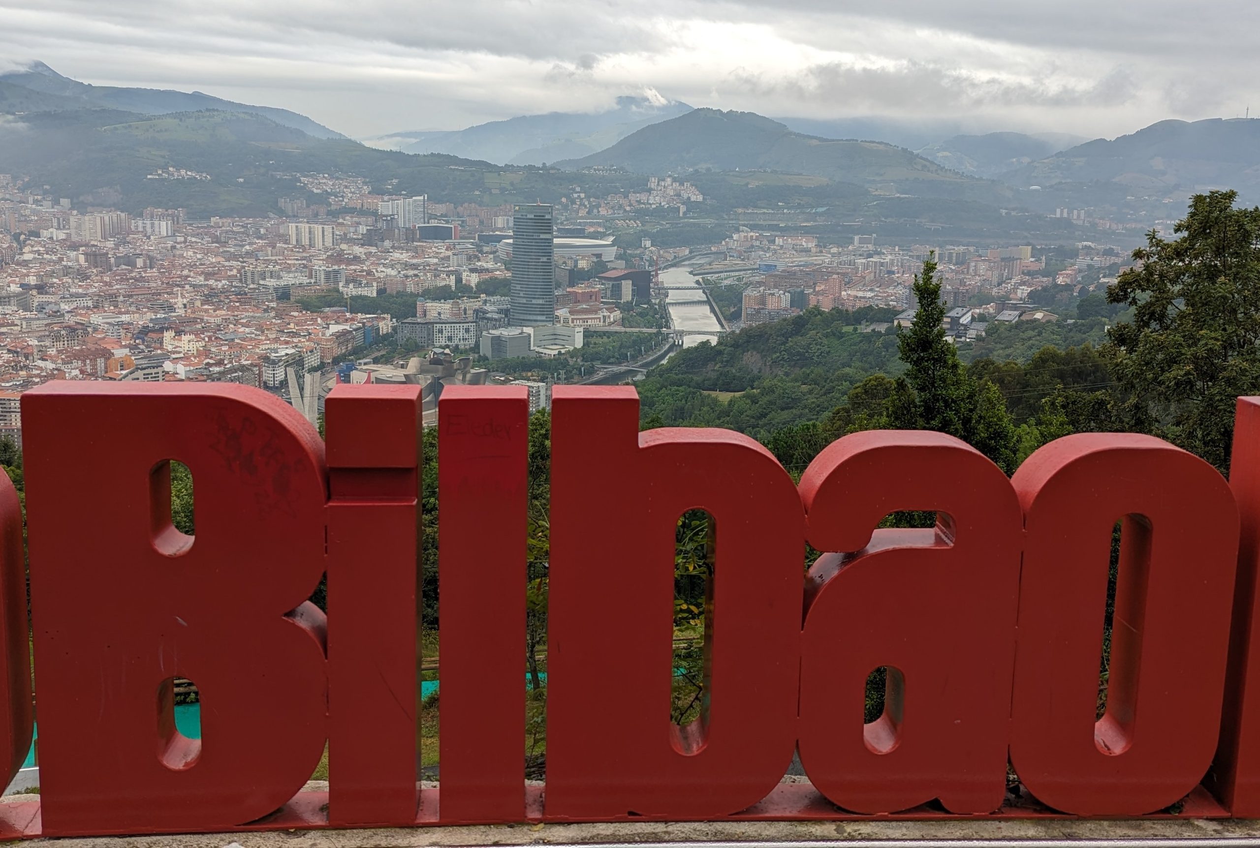
Hoy daremos un paseo por Bilbao, la capital de la provincia de Bizkaia y ciudad más poblada de la comunidad autónoma.
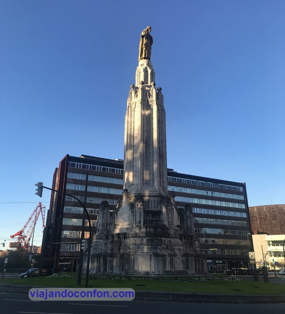
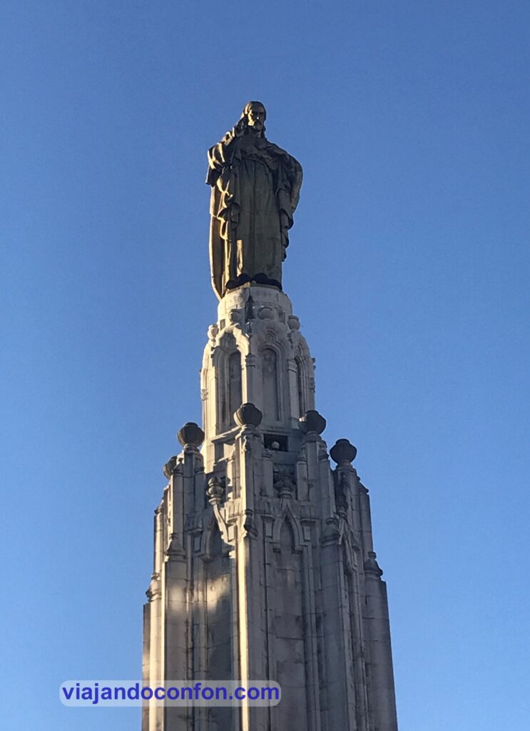
Sagrado Corazón de Jesús(Jesusen Bihotzaren monumentua)
Empezamos nuestro paseo en la plaza homónima, que une las avenidas de Sabino Arana y la Gran Vía Don Digo López de Haro.
Se construyó entre 1924 y 1927 por el Pedro Muguruza Otaño. Durante el gobierno del alcalde Ernesto Erkoreka (1931-1934 / 1936-1937) se aprobó su demolición y fue retirada de su pedestal.
El inicio de la Guerra Civil interrumpió su destrucción. Tras la guerra, la escultura se devolvió a su pedestal.
Cómo llegar: Metro San Mamés (línea 1). Tranvía Sabino Arana (línea 5).
Itsasmuseum Bilbao
Bajamos hacia la orilla de la ría, donde se encontraban antiguamente los Astilleros Euskalduna. Se inauguró en 2003, sus exposiciones pretenden difundir el patrimonio marítimo vinculado a la ría de Bilbao y su entorno.
A parte de las exposiciones interiores, en la explanada exterior podemos observar algunos elementos de manera gratuita barcos y elementos navales como , por ejemplo, la Grúa Carola.
La Carola es una grúa cigüeña construida por la empresa Talleres de Erandio entre 1954 y 1957 y era entonces la máquina elevadora más potente de toda España.
Tenía capacidad para levantar 60 toneladas de peso y era utilizada para la construcción de grandes barcos. Funcionó hasta el año 1984 en que se cerraron los astilleros.
Tras muchos años abandonada la adiquirió el ayuntamiento de Bilbao y la donó a la Diputación Foral de Vizcaya para que formara parte del museo.
Precio: 10€ la entrada general y 5€ la entrada infantil y jubilado. A parte del museo, también se encuentra la Bilbao 1803 Escape Room, con un precio que oscila entre los 60€ y los 100€.
Cómo llegar: Metro San Mamés (Línea 1). Tranvía Euskalduna (Línea 5).
Como siempre, recomendamos viajar con un buen seguro de viajes. IATI es especialista en seguros de viaje y, por ser nuestro lector, tienes un 5% de descuento.
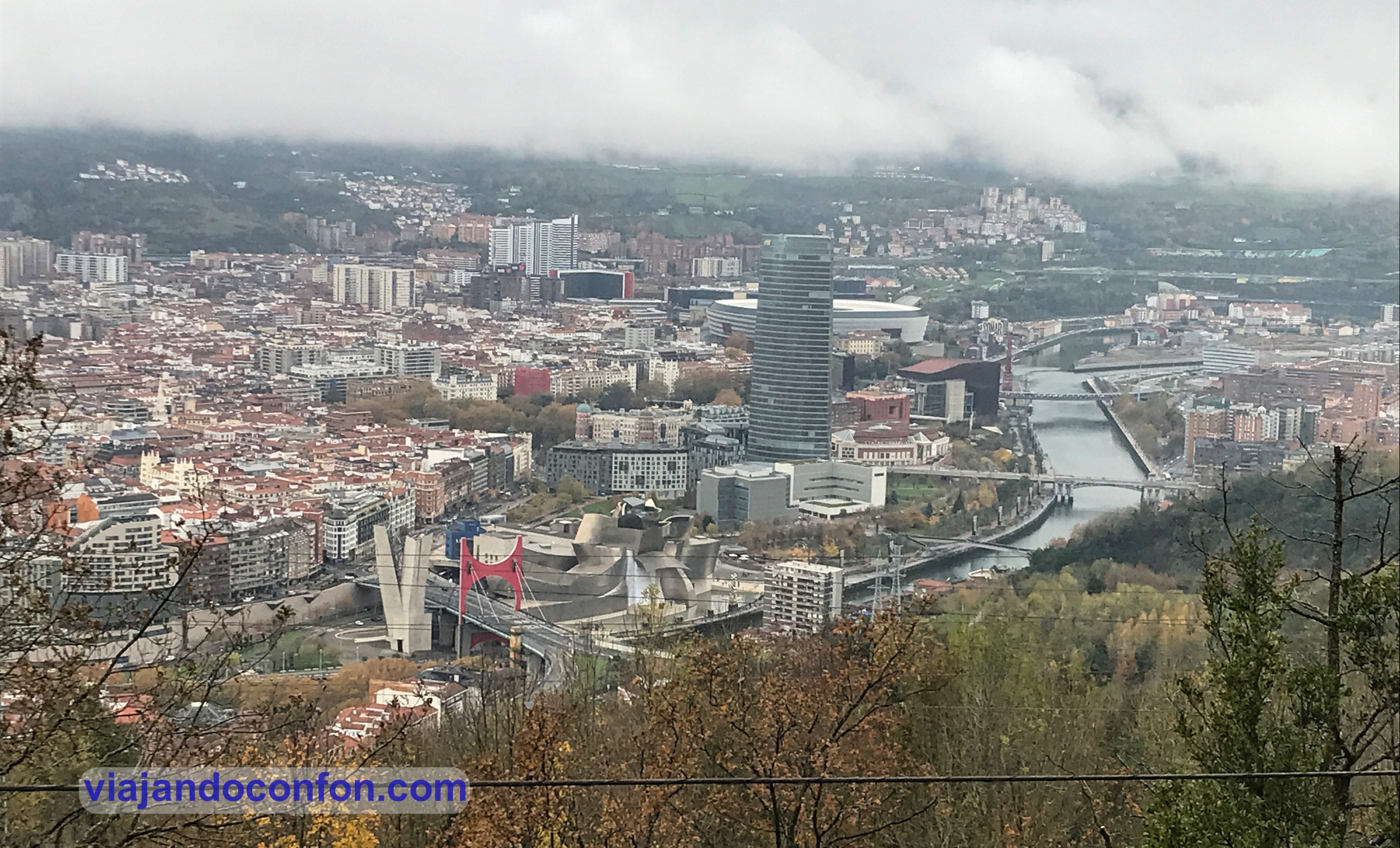
La ría de Bilbao es la desembocadura en el mar Cantábrico de la confluencia entre los ríos Nervión e Ibaizábal.
Se extiende durante 23 km hasta su desembocadura en el mar, entre los municipios de Santurce, Guecho y Ciérvana.
Divide la ciudad de Bilbao en dos. En la márgen derecha quedan Deusto, Uribarri, Begoña y Otxarkoaga-Txurdinaga. En la márgen izquierda quedan Basurto-Zorroza, Rekalde, Abando y Ibaiondo.
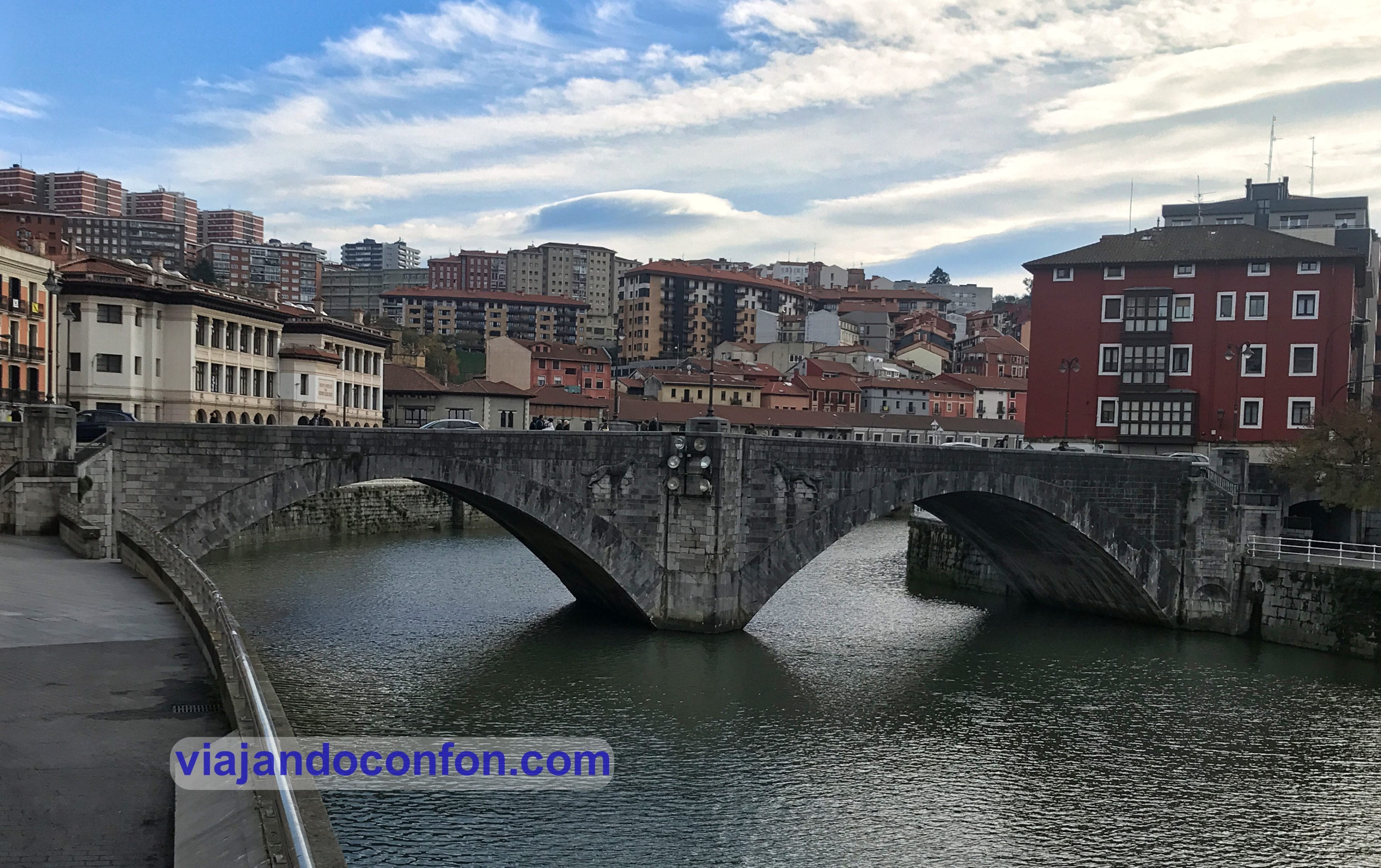
Puente de Deusto (Deustuko zubia)
El puente de Deusto es un puente basculante sobre la Ría de Bilbao. Comunica los barrios de Abando y Deusto.
Fue diseñoado en 1931 por el ingeniero de caminos, canales y puertos Ignacio de Rotaeche y al ingeniero industrial José Ortiz de Artiñano e inaugurado en 1936.
El 18 de junio de 1937 fue destruido durante la Guerra Civil como defensa de la ciudad. Fue reconstruido entre 1938 y 1939 y se nombró como Puente del Generalísimo, en referencia a Francisco Franco. En 1979 recupera su nombre anterior.
Museo Guggenheim (Guggenheim Bilbao Museoa)
El Museo Guggenheim es un museo de arte contemporáneo diseñado por el arquitecto canadiense Frank O. Gehry.
Se construyó entre 1992 y 1997, y fue inaugurado el 18 de octubre de 1997 por el rey Juan Carlos I de España.
La característica más llamativa del museo es el innovador edificio en el que se emplaza, constituido por formas curvilíneas y retorcidas, recubiertas de piedra caliza, cortinas de cristal y planchas de titanio.
El museo está vinculado en régimen de franquicia o colaboración con la Fundación Solomon R. Guggenheim desde 1994 aunque, tanto el edificio como su colección permanente pertenecen a las autoridades vascas.
Desde su inauguración ha causado un gran impacto en la economía y la sociedad vasca, impulsando el turismo. Este fenómeno es conocido como el “efecto Guggenheim” que ha conseguido la revitalización de numerosos espacios de la zona y mejorar la imagen de la ciudad.
Puppy
Se trata de uno de los iconos principales de la ciudad. Puppy, es un West Highland terrier de doce metros de altura recubierto de flore. Está instalado en el lado sur del museo. Es obra del artista estadounidense Jeff Koons del año 1992.
Escultura “Maman” Bilbao
Mamá (Maman), de casi 9 metros de altura, es una de las esculturas más ambiciosas de Louise Bourgeois y pertenece a una serie inspirada en la araña, motivo que apareció por primera vez en varios dibujos realizados por la artista en la década de 1940 y ocupó un lugar central en su obra durante la década de 1990.
Durante nuestro viaje de 2019 a Canadá, también pudimos contemplar la misma obra frente a la National Gallery of Canada en la ciudad de Ottawa.
Puedes verla en el diario de ese viaje: Canadá 2019
Información General
Cómo llegar: Tranvía Guggenheim (Línea 5).
Horario: de martes a domingo de 10.00 a 19.00. Cerrado los lunes.
Puedes contratar un fantástico tour privado por el Museo Guggenheim con Civitatis:
*Nos ayuda a mantener el blog
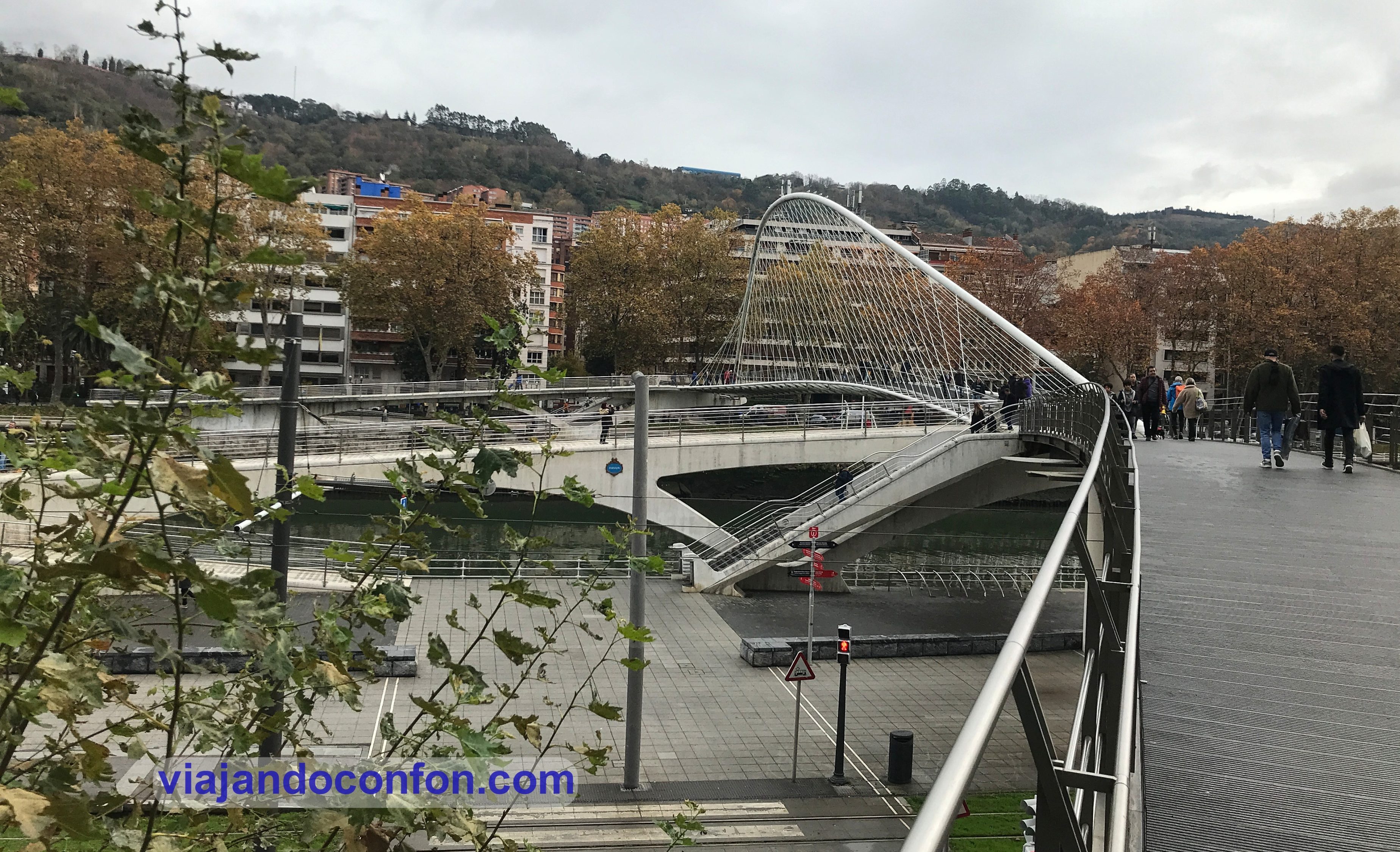
Puente Zubizuri
Construido entre 1990 y 1997, el pularmente llamado puente de Calatrava, fue diseñado por el arquitecto Santiago Calatrava. Une el Campo de Volantín, en la margen derecha, con Uribitarte, en la izquierda.
Debido a las numerosas caídas por resbalón que se producían en su suelo de baldosas de cristal con la lluvia, se optó por añadir una alfombra antideslizante. Sólo a un lumbreras se le ocurre poner suelo de cristal en una ciudad donde llueve 300 días al año…
También se descubrió que las baldosas de cristal se iban rompiendo por los cambios de temperatura, teniendo que sustituirlas regularmente. Un diseño digno de un crack.
En 2007 se construyó una pasarela, obra del arquitecto japonés Arata Isozaki, que une el puente con las Torres Isozaki.
Calatrava denunció en febrero de 2007 al Ayuntamiento de Bilbao por los derechos morales de la integridad de su creación. El motivo fue el corte de una barra de metal (para seguir cubriéndose de gloria).
El ayuntamiento opuso los derechos de los ciudadanos de Bilbao sobre los del arquitecto, aduciendo la funcionalidad de la nueva pasarela y recordando las caídas de los usuarios del puente y el coste de las reparaciones del suelo de cristal.
En noviembre de 2007 un juez Rodríguez Achúteguil dio la razón a Calatrava pero falló a favor del Concejo bilbaíno y permitió la conexión de Isozaki.
Tras la apelación del arquitecto la Audiencia Provincial de Vizcaya rectificó el dictamen del juez Rodríguez Achútegui. En marzo de 2009 condenó al Ayuntamiento a pagar 30.000 euros en concepto de indemnización al arquitecto. Cantidad que el arquitecto donó a la Casa de la Misericordia de Bilbao.
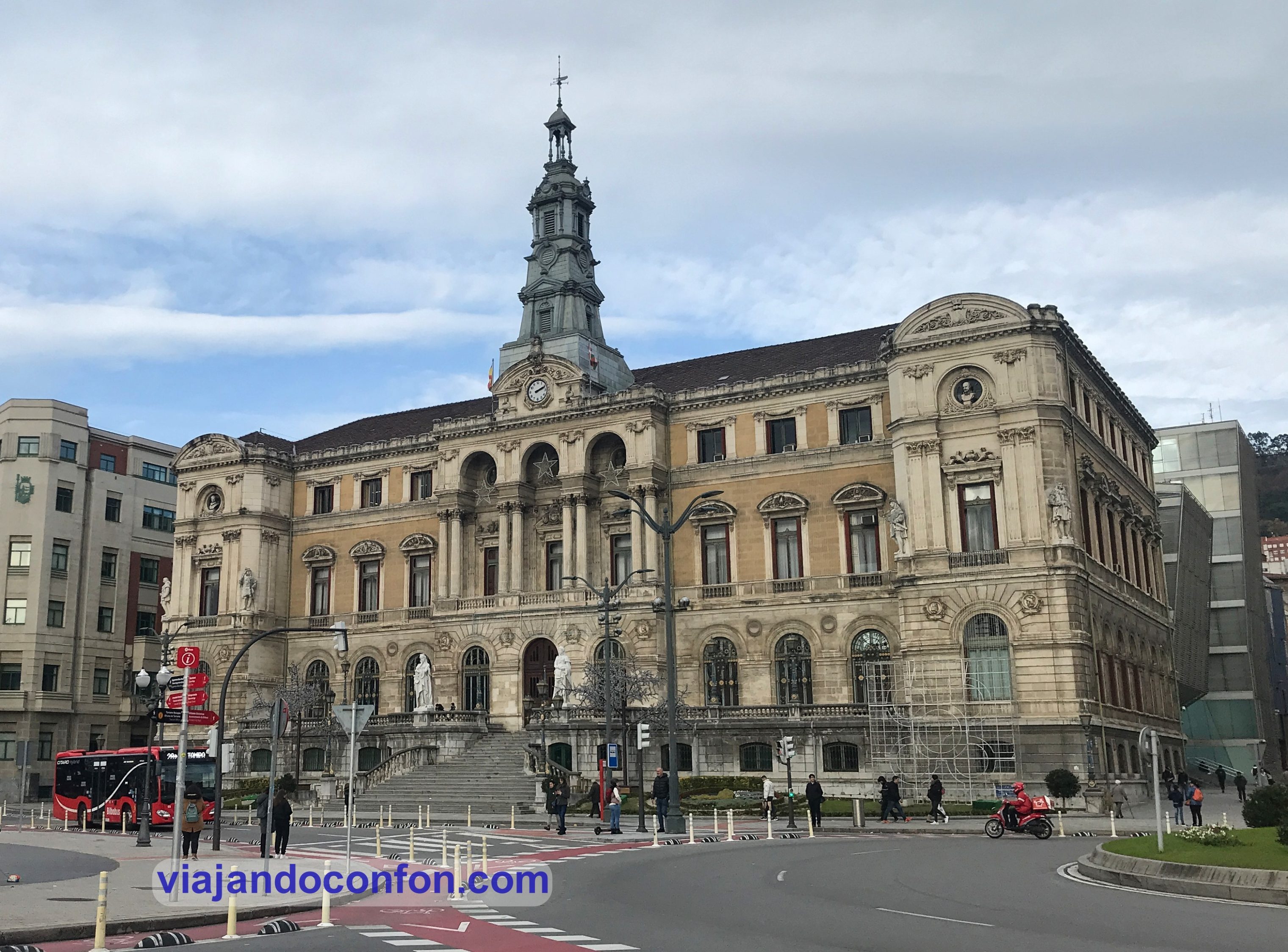
Casa Consistorial de Bilbao (Bilboko udaletxea)
La casa consistorial de Bilbao o casa de la villa de Bilbao es el principal edificio en el que se asienta el Ayuntamiento de Bilbao. Fue construido en estilo modernista, de carácter ecléctico, entre 1883 y 1892 según diseño del arquitecto Joaquín Rucoba.
Esta es la 4ª caa consistorial de la ciudad desde su fundación en el año 1300. La primera se construyó en 1535 frente a la iglesia de San Antón pero fue destruida en una inundación en 1553.
La segunda se construyó en el lugar de la 1ª en el año 1560 añadiéndose, además, una alhóndiga, un peso público y una sala de armas y municiones. También se la llevó una riada en 1593.
Se levantó entonces un 3º edificio. Con la industrialización de la ciudad en la segunda mitad del siglo XIX se hizo evidente la necesidad de superar los límites del Casco Viejo.
El edificio actual se construyó en el solar donde se encontraba antiguamente el convento de San Agustín, hasta que quedó en ruinas tras la Primera Guerra Carlista (1833-1840).
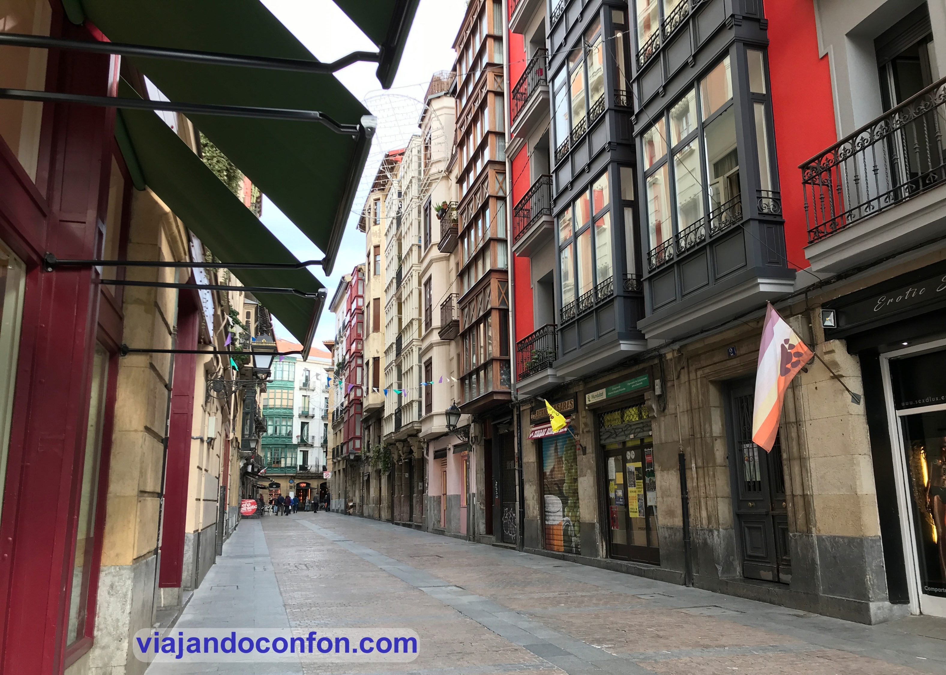
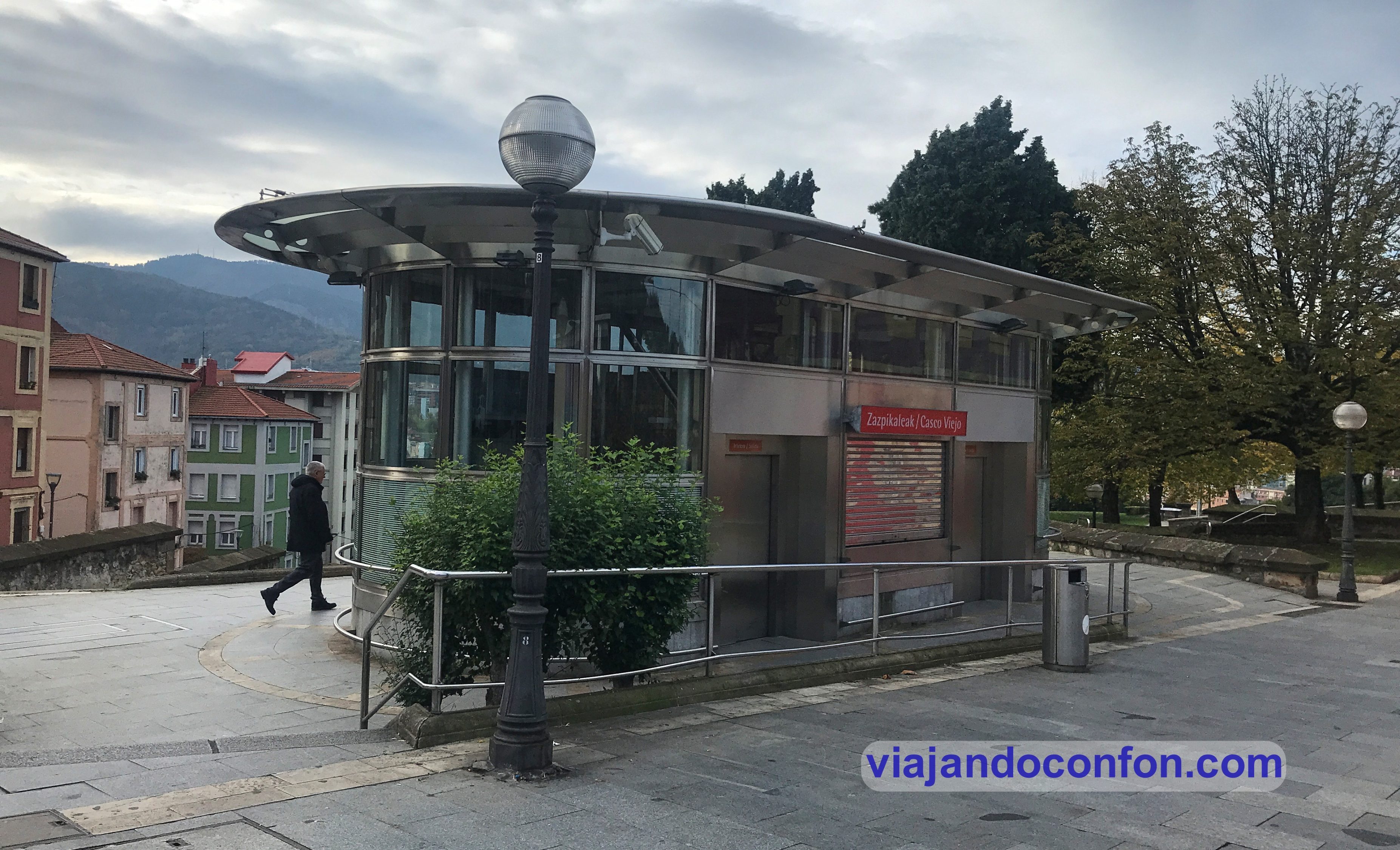
El Casco Viejo o Las Siete Calles (Zazpikaleak en euskera) es el barrio más antiguo y el núcleo originario de la villa de Bilbao. En él se encuentra (entre otros) la Catedral de Santiago y las iglesias de San Antón, San Nicolás y Santos Juanes.
Las siete calles que históricamente formaron el Casco Viejo son:
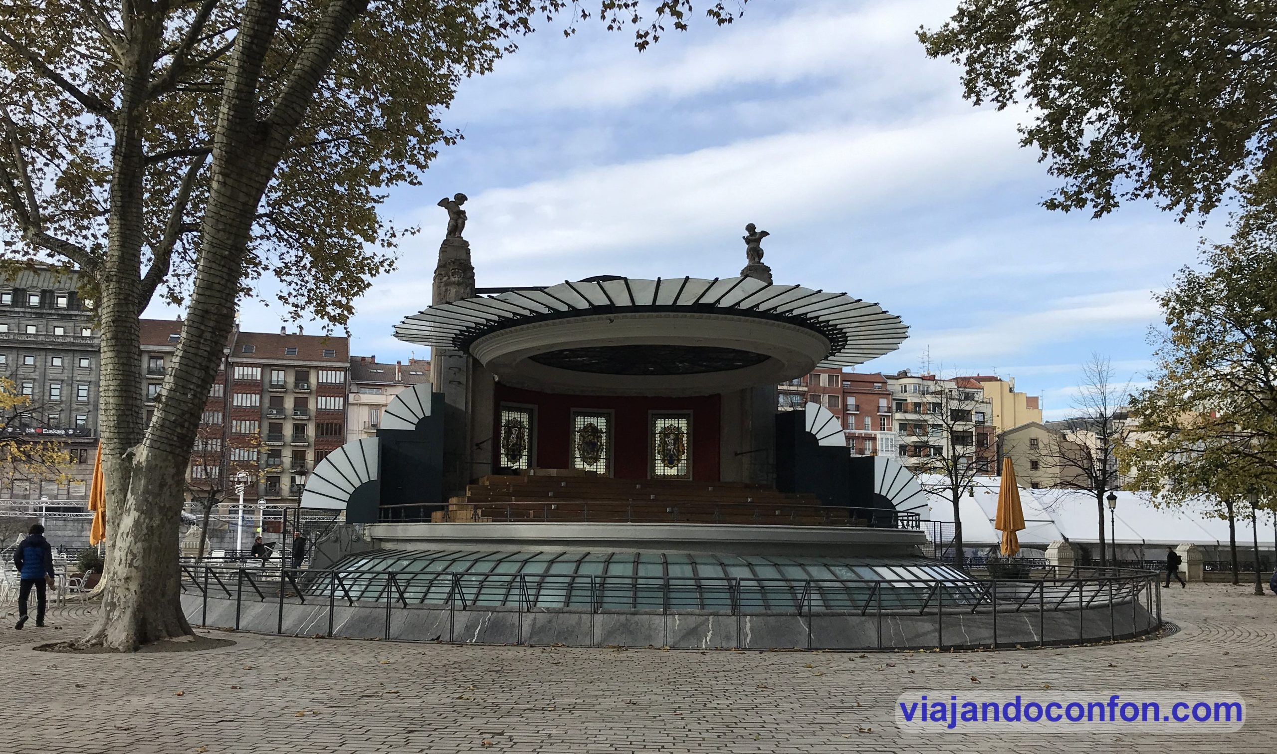
Se trata de un kiosko de música construido en 1928 por el arquitecto Pedro Ispizua.
Inicialmente fue diseñado en 1923 pero hubo que posponer su construcción por falta de medios económicos.
En 1985 el kiosko fue rehabilitado por Ramón Lecea restaurando sus vidrieras.
Iglesia de San Nicolás
La iglesia de San Nicolás es un templo católico construido entre 1743 y 1756 según proyecto del arquitecto Azpeitiarra Ignacio Ibero.
En este lugar se encontraba la ermita dedicada a San Nicolás de Bari, fundada en 1490. Esta iglesia fue destruida en unas inundaciones (como no). Fue entonces cuando se empieza a construir un nuevo templo en 1743.
La iglesia permaneció cerrada durante la Guerra de Independencia (1808-1814). También durante las Guerras Carlistas (1833-1840 y 1846-1849), en las que fue usada como polvorín.
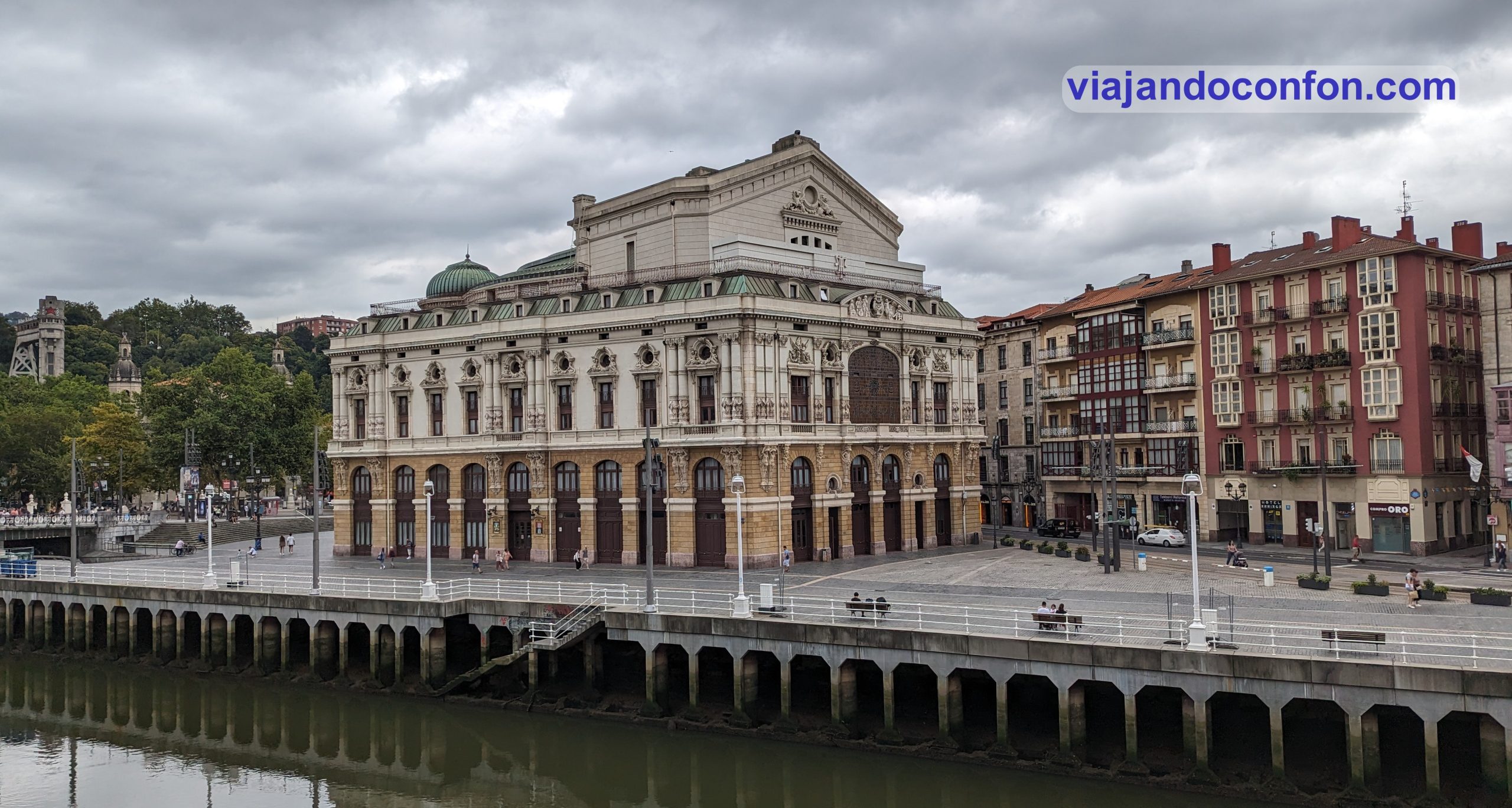
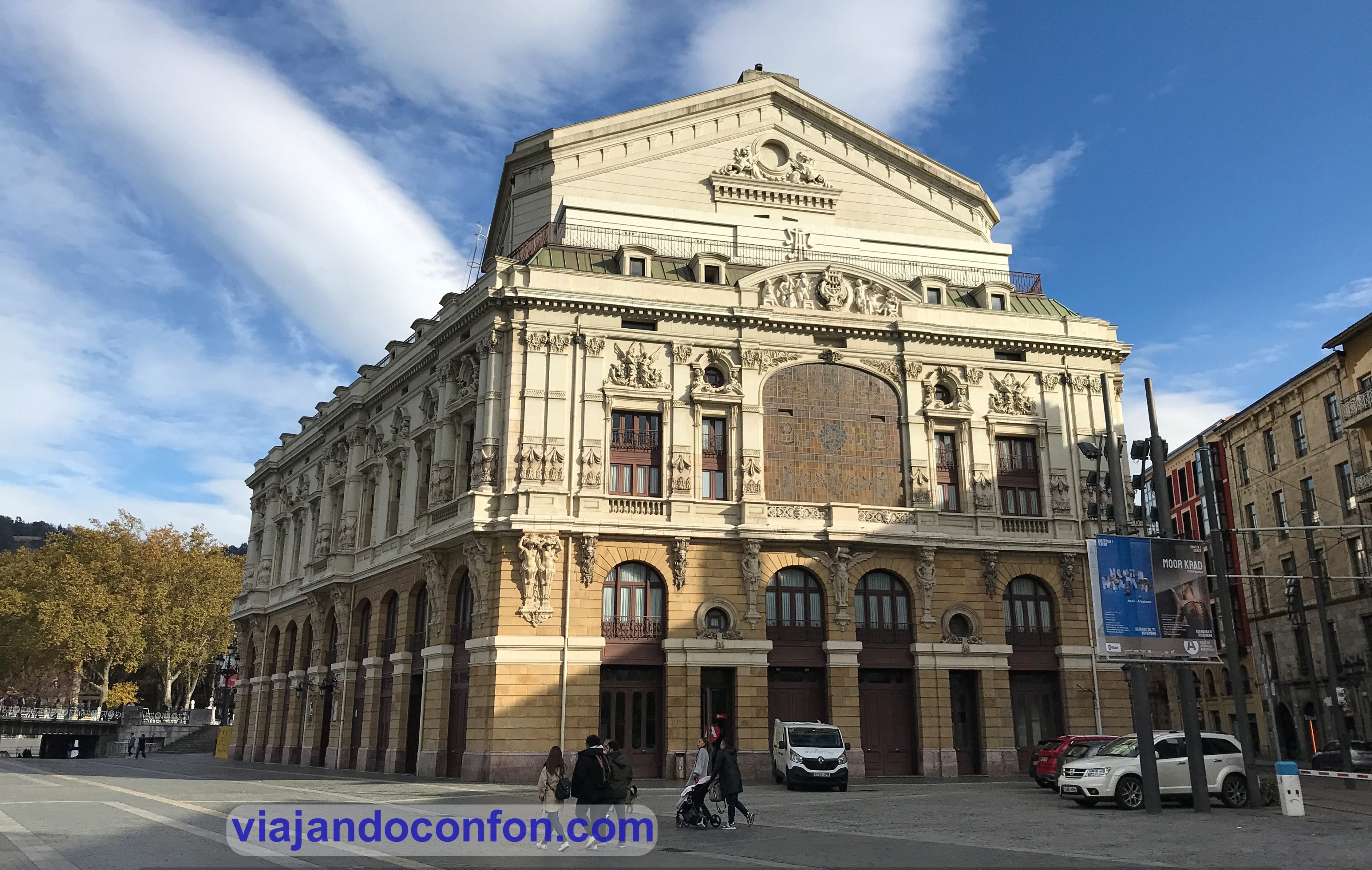
Teatro Arriaga (Arriaga Antzokia)
Se trata de un edificio construido entre 1885 y 1890 en estilo neobarroco. Es obra del arquitecto Joaquín de Rucoba y está dedicado al compositor bilbaíno Juan Crisóstomo de Arriaga, el Mozart español.
Fue inaugurado el 31 de mayo de 1890 con la representación de la ópera La Gioconda, de Amilcare Ponchielli.
Fachada delantera
En el lugar en el que se encuentra, se instala en 1834 el Teatro de la Villa, explotado por un grupo privado de capitalistas. Más tarde pasa a manos del empresario Luciano Urízar Echevarría.
El teatro es clausurado y derribado en 1886 por su estado ruinoso ya estando en construcción el nuevo teatro que lo iba a sustituir en el mismo lugar.
Aquí, en 1891, en los bajos del edificio se celebraron las primeras sesiones de la Bolsa de Bilbao.
El 22 de diciembre de 1914 el edificio es destruido por un incendio.
El 5 de junio de 1919 se reinaugura el edificio con la representación de la ópera Don Carlo de Giuseppe Verdi.
Durante las terribles inundaciones en Bilbao el 26 de agosto de 1983, el agua llega hasta el segundo piso del teatro dañando gravemente el edificio.
Se vuelve a reinaugurar el 5 de diciembre de 1986 con algunas modificaciones en su interior.
Fachada trasera
Cómo llegar: Tranvía Arriaga (Línea 5). Metro Casco Viejo / Zazpikaleak (Líneas 1, 2 y 3).
Comer pintxos en Plaza Nueva
Situada en el corazón del Casco Viejo, fue construida en estilo neoclásico entre 1829 y 1851. Realmente se proyectó en 1786 pero estuvo paralizado durante años.
Su construcción se repartió entre dos periodos. El primero, en 1821, estuvo a cargo del arquitecto Silvestre Pérez y entre 1825 y 1832 pasa a manos de Antonio de Echevarría.
El segundo periodo, entre 1840 y 1851, Avelino de Goicoechea toma el control modificando el proyecto de Echevarría.
La plaza tiene una superficie de 3.400 m y cinco accesos, de los cuales 4 son originales. Está llena de pequeños bares en los que los agotados viajeros podemos parar a descansar en tomar unos pintxos tranquilamente.
Cómo llegar: Metro Casco Viejo / Zazpikaleak (Líneas 1, 2 y 3).
Encuentra tu hotel ideal al mejor precio en Bilbao con Agoda:
*Nos ayuda a mantener el blog
Plaza Miguel de Unamuno
La plaza Miguel de Unamuno está situada en pleno Casco Viejo y está dedicada al filósofo y escritor bilbaíno Miguel de Unamuno.
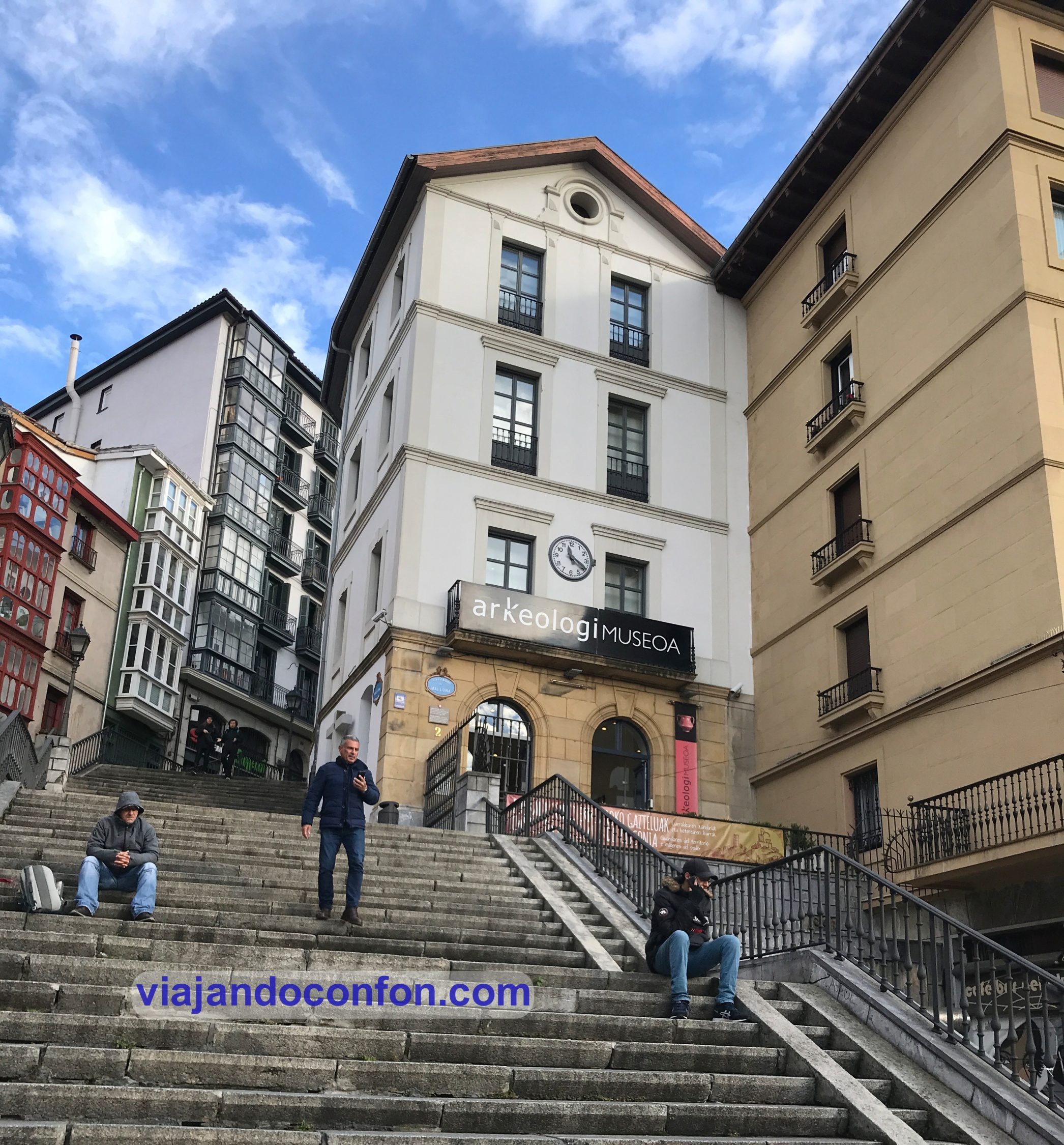
En esta plaza, a parte de sitios para tomar algo, hay varios elementos reseñables como el Museo Arqueológico Vasco (Bizkaiko Arkeologi Museoa) y el Museo Etnográfico (Vasco Euskal Museoa).
Museo Vasco (Euskal Museoa)
Iglesia de los santos Juanes
Se trata de una iglesia católica construida en estilo barroco clasicista y fundada en 1622. Hasta el siglo XVIII fue la iglesia del colegio jesuíta de San Andrés.
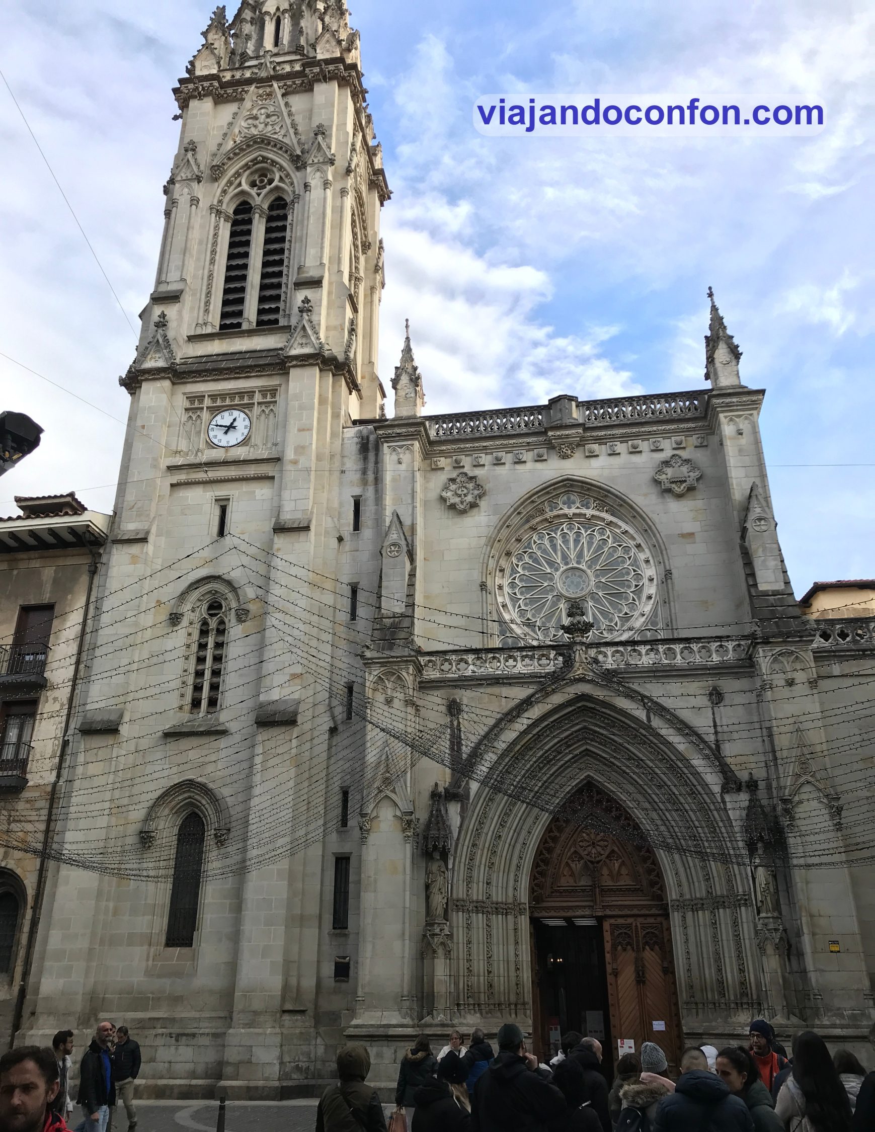
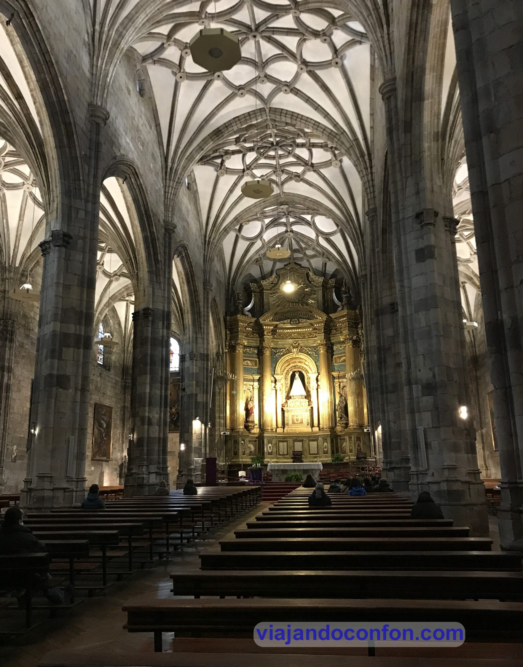
Catedral Basílica de Santiago
La Catedral Basílica de Santiago es un templo católico construido en estilos gótico, neogótico y renacentista. Su construcción empezó a partir de 1397 y finalizado en varios periodos de tiempo.
El edificio actual está construido en el mismo emplzamiento que sus dos antecesores. El primero es anterior a la fundación de la ciudad (1300).
El segundo templo realmente fue una ampliación del primero. Quedó destruido en un incendio en el año 1374. Tras ello, el Papa Gregorio XI dispensó indulgencias a quienes dieran limosnas para la erección de un nuevo templo.
En el año 1397 comienza su construcción, en estilo gótico que era el que imperaba en aquel momento. Estas obras se prolongarían a lo largo de un siglo. La obra se completa a principios del siglo XVI con la construcción de las capillas laterales, el claustro y la Puerta del Ángel.
El 3 de junio de 1931 es designado Monumento Histórico-Artístico Nacional.
En 1949 se convierte en catedral y sede de la Diócesis de Bilbao tras su separación de la Diócesis de Vitoria. Su desmembramiento se realiza tras la bula de erección Quo Commodius con fecha del 2 de noviembre concedida por el Papa Pío XII.
Como llegar: Metro Casco Viejo / Zazpikaleak (Líneas 1, 2 y 3).
Precios:
Iglesia de San Antón
Catedral + Iglesia de San Antón
General
8€
10€
Mayores de 65
7€
9€
Grupos (+15 pax)
4€
9€
Jóvenes (13 a 18)
7€
7€
Reducida
7€
7€
Fuente del Perro(Txakur kaleko iturria)
Se trata de una fuente construida en estilo neoclásico en el año 1800. Anteriormente era conocida como Fuente de San Miguel.
Está decorada con tres cabezas de leones, aunque se llame Fuente del Perro. Hay dos teorías sobre el origen de su nombre acutal.
La primera y más extendida es que, como los bilbainos dela época jamás habían visto un león, tomaron estas figuras por perros.
La segunda teoría es que el dueño de una casa de esa calle esculpió un león de piedra como guardían de su hogar. El resto de vecinos y viandantes, para mofarse de lo mal esculpido que estaba, decidieron tomarlo como un perro en lugar de un león. Fue tal larelevancia del hecho, que se decidió llamar a esta calle “calle del perro“. Más tarde la fuente adquiriría ese nombre.
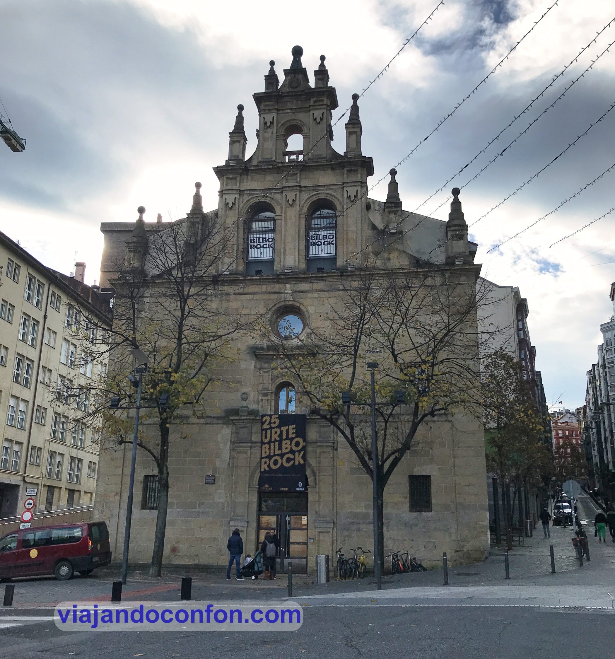
Acudir a un concierto en BilboRock
BilboRock es una sala de conciertos y espectáculos situado en una antigua iglesia desacralizada, junto al Casco Viejo.
La iglesia de La Merced fue construida en estilo barroco en el siglo XVII por los arquitectos Antonio Ortiz de Calina y Francisco de Elorriaga. Entonces formaba parte del convento de la Orden de las Mercedarias.
En los años 90 del siglo XX el edificio fue adquirido por el ayuntamiento de la ciudad para poner en marcha el BilboRock, siendo inaugurado 7 de abril de 1997.
Comprar o tomar algo en elmercado de la Ribera
El mercado de la Ribera es el mayor mercado de abastos cubierto de Europa. Está ubicado en la orilla derecha de la ría del Nervión junto al Casco Viejo, en donde se encontraba antiguamente la Plaza Mayor.
En este lugar se encontraba el antiguo mercado de la villa. Éste fue evolucionando hasta que en 1928 se toma la decisión de construir un nuevo mercado más grande y con lugar para más puestos.
El nuevo edificio, construido en estilo racionalista por el arquitecto Pedro de Ispizua, se inaugura el 22 de agosto de 1929.
En 1971, con la inauguración de MercaBilbao, la Ribera deja de ser un mercado de abastecimiento mayorista pasando a dar servicio de “mercado de barrio” al Casco Viejo y a Bilbao La Vieja.
Durante las inundaciones de agosto de 1983 sufre graves daños..
Horario: de miércoles a domingo de 8.00 a 00.00. Lunes y martes de 8.00 a 17.00.
Cómo llegar: Tranvía Ribera (Línea 5).
Iglesia de San Antón (San Anton eliza)
La iglesia de San Antón es un templo católico de estilo gótico de finales del siglo XV. Está construido el el solar donde se encontraba un antiguo almacén de mercancías fluviales, 300 años antes.
En 1334 Alfonso XI de Castilla construye en el lugar un alcázar y una muralla defensiva. No mucho después es demolido para construir una iglesia en honor de San Antonio Abad, consagrada en 1443.
Pronto se queda pequeña así que, en 1478 se proyecta una nueva construcción, que finaliza en 1510.
La iglesia sufre diversas modificaciones hasta 1775 en la que se termina el campanario. Aunque en 1902 se le añaden la sacristía y el pórtico actual.
El 17 de julio de 1984 San Antón fue declarado Bien de Interés Cultural con la categoría de Monumento Histórico-Artístico Nacional.
Horario: de lunes a sábado de 11.00 a 14.00 y de 16.00 a 18.00.
Precio:
Iglesia de San Antón
Catedral + Iglesia de San Antón
General
8€
10€
Mayores de 65
7€
9€
Grupos (+15 pax)
4€
9€
Jóvenes (12 a 18)
7€
7€
Reducida
7€
7€
La entrada es gratis para menores de 12 y nacidos en Bizkaia.
Cruzar el puente de San Antón
El puente de San Antón fue construido entre 1870 y 1880. Sustituyó al primer puente que funcionaba desde antes de la fundación de la villa en 1300.
Este antiguo puente fue durante siglos el único de toda la ciudad y era era paso obligado para el comercio de Vizcaya con Castilla. Imaginarse las hostias que habían por su control…
Durante el siglo XV, aquí era donde se ajusticiaba a los condenados a muerte. Se hacía por el método de empozamiento. Éste consistía en atar una soga al cuello del reo con una piedra en el extremo y arrojarlo al agua.
Durante la Guerra Civil fue destruido pero se volvió a edificar en 1937.
Peregrinar a la Basílica de la Virgen de Begoña (Begoñako Basilika)
La basílica de Nuestra Señora de Begoña es el santuario de la Madre de Dios de Begoña, patrona del señorío de Vizcaya.
El edificio fue construido entre 1511 y 1621 por los arquitectos Sancho Martínez de Asego y Martín de Garita (torre). Se levantó en el lugar en el que se encontraba un templo más primitivo.
Durante la invasión francesa, las tropas napoleónicas saquean la iglesia y asesinan al párraco.
La basílica supone un gran punto estratégico debido a su situación elevada. Ésto la convertía en un objetivo durante la Primera Guerra Carlista. Tras la retirada de los carlistas en 1835, las fuerzas liberales deciden destruir el campanario para evitar un futuro uso del enemigo. Al desplomarse, el campanario también destruye parte de las bóvedas.
Al año siguiente, son las fuerzas liberales las que defienden el edificio de las tropas carlistas. Entonces se quema lo que quedaba de la iglesia.
Tras la guerra se reconstruye la iglesa con fondos del ayuntamiento. Las obras acaban en 1850 y en 1869 se instala el retablo neobarroco.
Durante la Segunda Guerra Carlista (1846–1849) vuelve a ser destruida durante unos bombardeos e incendios posteriores.
Entre 1876 y 1881 se vuelve a reconstruir la basílica. El 27 de marzo de 1908, Roma otorga al templo el rango de basílica menor y en 1928 es consagrada de nuevo.
Cómo llegar: Para llegar a la Basílica de Begoña podemos subir andando el millón de escaleras que parte de la plaza Miguel de Unamuno.
La otra opción es tomar el ascensor Mallona, de Metro Bilbao, desde la estación de Metro Casco Viejo. Es de pago, como si fuera un viaje en transporte público. Es válida la tarjeta de transporte Creditrans Barik.
Ascensor de Mallona
Arco de Mallona
Construido entre 1828 y 1830 por el arquitecto Juan Bautista Belaunzarán, era la puerta del antiguo cementerio.
Se encuentra en las Calzadas de Mallona, construidas en 1745 sobre la pequeña meseta delantera del Monte Artagan.
El cementerio, el primero de la villa, permaneció en uso desde 1830, cuando los franceses prohibieron los enterramientos en las iglesias a partir de 1808, hasta el año 1927.
Pasaremos por delante si subimos andando hacia Begoña desde la plaza Miguel de Unamuno. También queda muy cerquita del ascensor de Mallona.
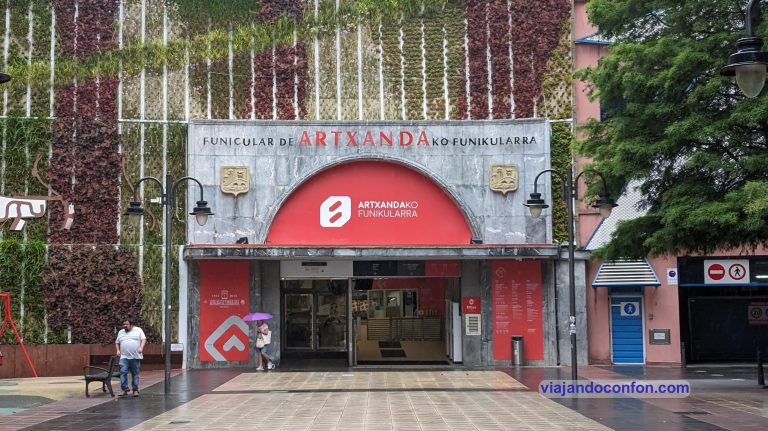
Subir en funicular a Artxanda (Artxandako funikularra)
Si quieres contemplar las mejores vistas de Bilbao, este es el sitio. Pero para subir, nada mejor que tomar el funicular.
El funicular se instaló en 1915, con un proyecto de Evaristo San Martín y Garaz. El 7 de octubre de ese mismo año se realiza el primer viaje. La maquinaria fue diseñada por una empresa suiza, especialista en trenes de montaña L.Von Roll.
Durante la Guerra Civil se destruyen las vías y la estación. El 18 de julio de 1938 se reinicia el servicio. El precio era entonces de 60 céntimos de peseta (0.0036€) y se usaba para transportar todo tipo de cosas, desde personas hasta ganado.
El 25 de junio de 1976, tras una cadena de fallos, el vagón se precipita hacia la estación inferior con dos heridos, ambos empleados del funicular. Tras el accidente, el funicular queda suspendido durante 7 años.
A principios de 1983 se reconstruyen las vías y las estaciones y se reinaugura en abril de ese mismo año.
En la parte alta encontraremos un parque con un mirador. Desde allí tendremos unas espectaculares vistas de la ciudad. Merece mucho la pena.
Tiene una frecuencia de 15 minutos y el viaje dura 3. Si se acumula mucha gente se aumenta la frecuencia.
El precio del viaje es de 3€ un viaje y 5€ ida y vuelta. Es válida la tarjeta de transportes Barik y el precio con esta es de 0.42€.
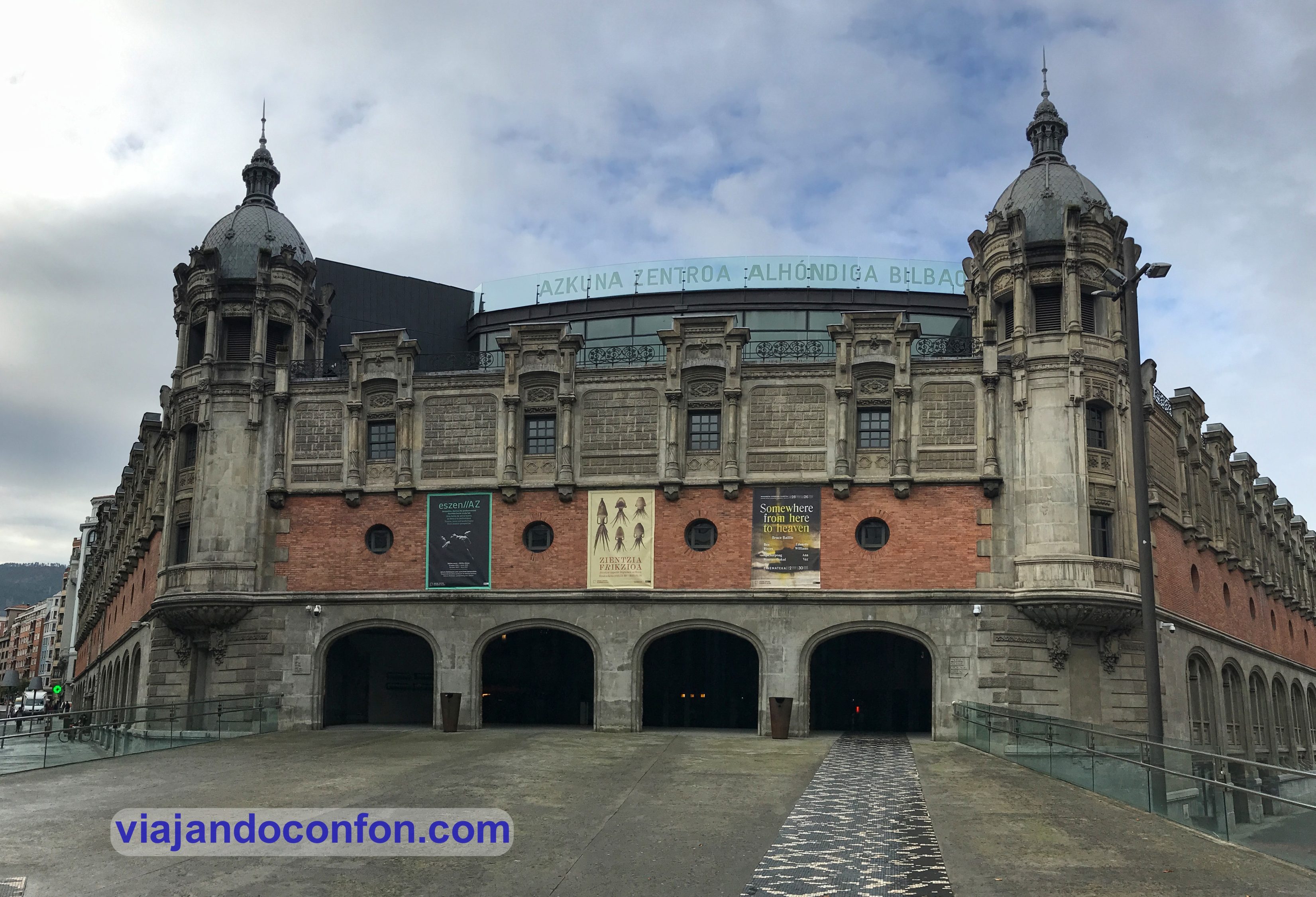
Visitar la Alhondiga Bilbao – Centro Azkuna (Azkuna Zentroa)
Se trata de un antiguo almacén de vino reconvertido en centro de ocio y cultura. Fue construido entre 1905 y 1909 según proyecto del arquitecto Ricardo Bastida y Bilbao.
El 4 de junio de 1977 se clausuraba la alhóndiga tras la inauguración de una nueva en Gaztelondo. Tras su cierre se promovieron algunos proyectos para darle un nuevo uso pero ninguno salió adelante.
Tras décadas cerrada, en mayo de 2010 era reinaugurado como centro cívico polivalente. La restauración del interior fue diseñada por el diseñador industrial francés Philippe Starck.
El 16 de marzo de 2015 pasa a denominarse oficialmente Azkuna Zentroa (Centro Azkuna) en honor a Iñaki Azkuna en reconocimiento del que fue alcalde de Bilbao.
El interior del edificio es precioso y el interior… curioso. Tiene un espacio abierto enorme en el que encontramos multitud de columnas que son auténticas obras de arte. Todas diferentes.
Tras hacer multitud de fotos en su interior, justo antes de salir, había carteles que dicen que no se pueden publicar fotos del mismo… así que las guardaré para mi.
Cómo llegar: Metro Indautxu (líneas 1 y 2). Bus Bizkaia Plaza (líneas 18 y 62).
Barrio de Irala
Conocido como el Notting Hill bilbaino, es una serie de calles con casas de estilo inglés cuya fachada está pintada con llamativos colores.
En 1902 Juan José Irala y sus socios fundaron la mayor panificadora de la ciudad, Harino Panadera. Con la necesidad de contratar numerosos trabajadores, Irala mandó construir un barrio de viviendas para ellos. Así es como nace Iralabarri.
Cómo llegar: bus parada Juan De Garay / Gobierno Militar línea 1 // También podemos llegar dando un paseo desde el centro (15 min desde la Alhóndiga).
Callejón Zollo
El callejón Zollo es un callejón situado a la altura del número 11 de la calle Alameda San Mamés. Antiguamente conectaba Alameda San Mamés con la calle Iparraguirre. En principio era uno de los lugares donde se ataban los caballos de los carros que abastecían a la Alhóndiga.
Hace unas décadas los propietarios de las lonjas adecentaron el callejón pintando las paredes de blanco; y las puertas y ventanas de azul. Puntualizar que por las noches se cierra el acceso al callejón.
…No te olvides de los pintxos
Como buen turista gastronómico, me encanta. En casi todos los bares vascos los encuentras. Pequeñas porciones de comida para picar algo mientras te tomas tu cervecita (o cualquier bebida).
Expuestos de una manera muy atractiva para llamar bien la atención. No te podrás resistir.
Descubre las mejores actividades al mejor precio en Bilbao con Civitatis:
*Nos ayuda a mantener el blog
Aquí encontrarás un mapa con todos los puntos a visitar en Bilbao:
Descubre todo sobre el mundo a través de nuestros diarios de viaje.
We continue our route through Iceland. We are going to the Westfjords, the region of the west fjords. We woke up very early in the city of Akureyri.
Akureyri is the capital of northern Iceland and the most populous city outside of the Reykjavik metropolitan area, with just under 18,000 inhabitants.
The city was founded in 1778 and has been an important fishing center throughout its history. It was also one of the allied military bases during World War II.
July 21st
We wake up to the sunny day and hit the road on the go. Many kilometers of car await us today. We headed to the Westfjords, the western fjords.
In the Westfjords, more than tourist spots, it is admiring the spectacular natural scenery.
The first stop was going to be Hvítserkur, although before arriving we stopped several times to admire the impressive landscapes.
From the car
Along the way we came across a herd of horses that were moving from one place to another. It was wonderful to see so many horses, although you have to be very careful because they are on the road.
After about 2.30 hours on the way (with a stop for breakfast) we arrive at Hvítserkur.
Hvítserkur, also known as the Northwest Icelandic Troll, is a 15 m (49 ft) high basalt rock stack jutting out of Húnaflói Bay.
Folklore says that Hvítserkur was originally a troll from the peninsula, determined to rip the bells out of the Þingeyraklaustur nunnery (trolls are believed to fear Christianity). He was so enraged and persistent in his enterprise, that he did not notice the dawn, and was instantly petrified for eternity by the sun’s rays.
Hvítserkur
We return to the car and approach a nearby cafeteria that we had passed on our way. We park and, before ordering a coffee, we approach the services outside. Like many in Iceland they were paid. The difference is that this one cost 700 ISK. €5!!!!
Coffee was another bundle so we passed. A little mouthful of water and the road.
Our next long stop was going to be in Hólmavík, 190 km away. This is where we ate.
The scenery up to Hólmavík was still spectacular.
We arrived in Hólmavík at lunchtime. We stopped at a supermarket called Krambúðin to buy things for dinner before looking for a place to have lunch. Upon entering we saw that right there was a part that was a hamburger. Since the city was not very big (300 inhabitants) and we didn’t feel like looking for a restaurant… Well, “go ahead”.
The hamburger was very simple but it was not bad and it was cheap.
We eat, refuel and hit the road to enjoy the Westfjords.
During the journey, while we skirted the Ísafjarðardjúp fjord, we passed by an abandoned-looking building that caught our attention. This is Arngerðareyri Kastalinn, a farm built in 1928. In its heyday there was a shop, a “traffic center”, a telephone exchange and a school.
The building was abandoned in 1966 due to the depopulation of this rural area of Iceland. In 2020, restoration works began on the building. I love abandoned places.
A few photos and we continue on our way.
About 150 km from Hólmávik there is a seal watching area. On google maps it appears as Seal lookout at this address: X5VP+F43, Litlibær, Iceland. But hey, it’s well signposted.
About 2:30 hours after leaving Hólmávik we arrived at our accommodation for that night: Súðavík Tours & Guesthouse, in the city of Súðavík. It is a small guesthouse with a kitchen and a shared bathroom, quite well priced for the Westfjords: €152 per night.
Find the best hotels in Iceland at the best price with Agoda:
Súðavík is a tiny fishing town on the Álftafjörður fjord with a sad recent history.
On January 16, 1995, around 6:30 in the morning, there was a huge avalanche that buried most of the city. 14 people died (8 children) and 12 were injured. The large amount of accumulated snow made rescue work tremendously difficult. The last person was found 23 hours after the disaster.
On January 23 of that same year, it was decided to rebuild the village in another less dangerous location, including the fishing facilities.
We settled in our room, showered and found something for dinner. For this we went to the nearby city of Ísafjörður, about 20 km away.
Road to Ísafjörður
Ísafjörður is the capital of the Vestfirðiry region. It is the largest city in the region with 4,000 inhabitants. Its economy is mainly based on fishing, which has one of the largest fisheries in Iceland.
Located on the shores of the Skutulsfjördur fjord, it is the northernmost city in Iceland, just 50 km from the Arctic Circle.
Because of its isolation, Ísafjörður has developed a great urban atmosphere. The city has a music school and a hospital.
The first settlement in Skutulsfjördur was established in the 9th century by the Viking Helgi Hrólfsson “the Thin”. The city prospered during the 16th century thanks to its establishment as a trading post for foreign merchants.
The local museum contains the oldest house in Iceland, built in 1734. The largest collection of old wooden houses in Iceland is in this sector. The houses were mostly built by foreign merchants in the 18th century.
Westfjord History Museum
The entrance costs 1,500 ISK but by the time we arrived it had been closed for hours…
Right next to it is Tjöruhúsið, a very famous Icelandic restaurant for which they recommend making a reservation days in advance. Still we tried to get in. No luck.
We left looking for another place. In the end we ate at Edinborg Bistro. We had a scandalous dinner and it was not too expensive. 6,980 ISK (€50).
Edinborg Bistro
By the way, at night the restaurant turns into a pub.
After the abundant dinner (without irony) we went for a “night” walk through the city.
We end the day returning to Súðavík to sleep with the (almost) midnight sun in the background.
11 p.m.
July 22nd
Today is another long day in the car. Today we sleep at 387 km.
We have a leisurely breakfast and we set off. As a curiosity, we went through the longest vehicle tunnel in Iceland. The Vestfirðir Tunnel is 9 km long and… it only has one lane. The main direction is northbound and for those of us going south we have sidings every few meters. Well thought.
Before reaching the first destination… stop for photos in an idyllic landscape.
Holt
First scheduled stop: Dynjandi (Thundering).
Dynjandi are a series of waterfalls whose main one is the largest in the Westfjords. It is located close to Dynjandisvogur bay and Arnarfjörður fjord, an area very famous for its richness in birds and impressive natural views.
We park and as soon as we get off, the cloud of mosquitoes from those tiny little girls assault us. This time it has been really desperate. There was a moment when I was so overwhelmed that I thought about turning around. Luckily I didn’t.
From the car park we start to climb and leave behind seven waterfalls: Hæstahjallafoss, Strompgljúfrafoss (Strompur), Göngumannafoss, Hrísvaðsfoss-Kvíslarfoss, Hundafoss and Bæjarfoss (Sjóarfoss).
Bæjarfoss
The speck at the top of the photo is not a bird. It’s one of the shitflies she was talking about. In some photo it comes out perfectly in the very center.
Göngumannafoss
And already above all the spectacular Dynjandi.
Dynjandi is known as the “Bridal Veil” for its resemblance to this garment. It has a 100-meter drop and is 30 meters wide at the top and 60 at the base.
The walk from the car park to Dynjandi is approx 200m uphill with some steps.
With regret for leaving such a wonderful setting we hit the road again.
We continue to be amazed by the spectacular landscapes that the little-known region of the Westfjords offers us.
Our next scheduled stop was Helgafell, Snæfellsnes peninsula almost 300 km away. Outside the Westfjords 4 hours away.
But before there is some non-improvised stop, like lunch. We stopped in a town called Búðardalur, 200 km away. We ate at a pizzeria called Dalakot, which is also a guesthouse.
We ate wonderfully again and at the more or less usual price: 6,400 ISK (€46) for a large pizza, a very complete salad and two drinks.
The pizza was delicious. After lunch we set off again. With some stop… of course.
83 km later we reach Helgafell, located in Thorsnes. Here we find a farm and a church at the foot of a hill, which is what interests us.
At the time of the settlements, also at the foot of the hill was a temple in honor of the thunder god Thor (Þór) built by Þórólfr Mostarskegg in the 9th century.
According to the Laxdœla Saga, the heroine Gudrun Osvifursdottir (974 – 1060) is buried next to the hill. In these pagan times the mountain was said to be the home of the dead.
Helgafell Hill is 73 meters high and the entrance fee is 400 ISK. From the top we have a truly spectacular 360º view.
We go down the hill and we are on our way to the next point of interest: Berserkjahraun.
Berserkjahraun is a 4,000-year-old lava field located on the Snæfellsnes peninsula. Its name comes from one of the Icelandic Eyrbyggja saga.
According to this story a farmer brought two berserkers from Sweden to the Snæfellsnes peninsula. He gave them to his brother, Beam-Styr, who lived on the other side of the lava field. One of these berserkers fell in love with the daughter of Beam-Styr and asked for her hand in marriage.
Beam-Styr made a deal with the berserker. If he cut a path through the lava field connecting the farm with his brother’s, he would grant her his hand.
Between the two berserkers they managed to open a path very quickly. A fact that was practically impossible. Víga-Styr had the two Swedes killed and buried near the road.
In Berserkjahraun we can find four landmarks. Those are Berserkjagata, the road itself, Berserkjadys, where the two Berserkers are supposed to be buried, Landamerkjagarður, a border fence, and Fjærrét, a sheep shelter.
Already very close is Grundarfjörður, where we had our accommodation that night.
Grundarfjörður is a small town of about 900 inhabitants located on the north coast of the Snæfellsnes peninsula. Nestled in a natural harbour, its main industry is fishing and fish processing. In recent years the tourism sector has also prospered.
Next to the city we find the Kirkjufell mountain.
Kirkjufell
Kirkjufell, which translates as Church Mountain, is the most photographed mountain in Iceland… or so it is said.
The mountain takes its name from its resemblance to a church steeple, tapered at the top with long curved sides. From other angles, the mountain has been compared to a witch’s hat or even ice cream (you have to use your imagination).
To stay we chose the Stöð Guesthouse and Apartments. It was really good. Very spacious room with a private bathroom… the first in Iceland. In principle it cost us €117. And I say in principle because a few days later we realized that €144 had been charged to our account.
We complained and they told us that they would refund us a maximum of 30 calendar days. After the deadline we still did not receive the money. We returned to claim and this time yes, they returned it to us in 2 days.
I have to say that if the accommodation had cost €144, it would also be worth it.
Find the best hotels in Iceland at the best price with Agoda:
We left our things in the room and went for a walk around the town, which was having a local holidays.
In the church square there were remains of a popular barbecue, to which we arrived late. At that time there was a bike freestyle exhibition and shortly after a concert began. It wasn’t very cold and it was fine.
We took a short walk through the town, enjoying the spectacular surroundings and we went looking for somewhere to dine… one of the few that there were.
Grundarfjörður Church
Of the few options that were available for dinner, we chose Harbour Cafe. It was packed and we had to wait, but not long. It did not have a very extensive menu, so it was easy to decide. We succeeded again. We had a wonderful dinner and at a good price: 6,600 ISK (€47), average.
After dinner, to bed to rest. A long day awaits us.
July 23rd
We got up early, had some breakfast and we set off.
The first stop was going to be Kirkjufellsfoss, but since you had to pay 500 ISK and it looked good from the road… We saved money. It’s not too spectacular.
We continue our way to the city of Ólafsvík. There we would contemplate the Bæjarfoss waterfall. Don’t waste time and go on your way. It’s nothing spectacular.
The city church is curious.
After the little disappointment we set off for Svöðufoss. This one is quite spectacular.
Svöðufoss is a beautiful 10-meter-high waterfall that pours between basalt columns into the Hólmkelsá River.
The setting in which it is located is truly spectacular, with the watchful summit of the Snæfellsjökull volcano with its glaciers.
Snæfellsjökull is a stratovolcano 700,000 years old and 1,446 meters high. The mountain is actually called ‘Snæfell’ (Snow Mountain), although ‘jökull’ (Glacier) is often added to help distinguish it from other mountains of the same name.
In August 2012, it ran out of snow for the first time in its history. Fact that generated concern among the locals that climate change threatens the nature of the mountain.
For centuries, Snæfellsjökull has been considered, as one of the world’s ancient places of power, a source of mysticism, energy and mystery to the area’s superstitious population.
There are many rock formations in and around Snæfellsjökull that are said to be sunlight petrified trolls or houses of hidden people.
On November 5, 1993, thousands of paranormal enthusiasts flocked to Snæfellsjökull in the belief that an alien spacecraft would land here. People get very bored.
From Svöðufoss we went directly to the Saxhóll crater 18 km away.
Along the way we passed a section where we were warned of the possible presence of suicide birds. Well, there could be thousands there. Without exaggerating. And hundreds of them smashed to the ground. Luckily we didn’t run into one. Of course, we throw away half a life to travel a couple of kilometers.
Saxhóll crater
Saxhóll is a crater about 100 meters high and is one of the most popular on the Snæfellsnes peninsula. You can go up through a stepped path that starts from the car park. From the top we can enjoy an impressive view of the lava fields that surround the entire area.
Views from the crater
There was no time to waste so on the way down we set off for Djúpalónssandur.
Djúpalónssandur is an arc-shaped bay of dark cliffs and black sand. Formerly here was a small and prosperous fishing village that was left abandoned.
Djúpalónssandur Beach stands out for its impressive coastal lava rock formations including a large lava rock with a hole in the middle through which you can directly see the Snæfellsjökull glacier volcano.
Behind the rocks there are two freshwater lagoons called Djúpulón and Svörtulón, the first being the one that gives the bay its name. Although in ancient times they were believed to be bottomless, it was later revealed that the bodies of water reached a depth of only five meters.
Most of the photos I took in Djúpalónssandur are damaged and I have not been able to repair them despite having used many programs for it. If anyone knows someone who can help me…
Svörtulón is believed to possess healing properties, having been blessed by Bishop Guðmundur góði (‘the good’) in the late 12th century.
(DAMAGED PHOTO)
Discover the best activities and tours in Iceland with Civitatis:
We also find the natural monument Söngklettur (“singing rock”), a large lava rock with a reddish hue that resembles an elven church. Nearby are other rock formations of folkloric appeal, including the reputed stone trolls of Kerling and Lóndrangar.
We went down from the parking lot. Upon reaching the sand we find a series of stones lined up next to an informative sign. These stones were used by fishermen to measure their strength. Its weight varies between 23 kg of the lightest to 155 kg of the heaviest. Their names are Amlóði (useless), Hálfdrættingur (weak), Hálfsterkur (half strong), and Fullsterkur (fully strong).
You know, here you can try your strength to see if you would have been a good sailor. And it is better for me to dedicate myself to cooking, which is my thing…
(DAMAGED PHOTO)
We can also find a lot of very rusty iron remains all over the beach. This is the remains of a British trawler called the Epine GY 7 from Grimsby which sank in 1948 near the beach. 14 of the 19 crew members of it died. The remains are preserved here as a memorial to those who disappeared.
From the beach there is a small path of approximately 1 km to the cove on the west side. During the journey we can see remains of the constructions of the fishermen who inhabited the area and some explanatory panel. Unfortunately I have lost all those photos.
Time to leave for the next destination: Lóndrangar.
The basalt cliffs of Lóndrangar are among the many geological wonders of the Snæfellnes peninsula.
Here was a volcanic crater that was gradually destroyed by the force of the sea. Today only two columns of 75 and 61 meters high remain as witnesses. They are known as “the Rocky Castle”.
In Icelandic folklore the surrounding lands are believed to have never been cultivated as they are believed to be inhabited by elves.
Return to the car and follow the path. There are still things to see before going to the capital.
The next stop is Arnarstapi. It is a small former fishing village, although today it is more touristy.
Records of settlement around Arnarstapi date back to the Bárðar Snæfellsáss saga (c. 14th century), an ancient Icelandic saga that tells of the half-human, half-ogre who once lived on the Snæfellsnes peninsula. Since his death, he has been considered the guardian spirit of the area.
During the Norwegian and later Danish occupation, it prospered as a fishing and trading port. Many of the resulting buildings still stand today, some of the oldest in the country, such as the Danish Prefect’s Residence, which was built in the 1770s.
The Icelandic industrial revolution caused much of its population to move to the capital, Reykjavik, reducing its size to little more than a village.
We parked in one of the city parking lots and started our walk towards the coast. The first thing we come across is a monument called Minnisvarði um Bárð Snæfellsás, the protector of Snæfellsás.
Bárður Snæfellsás was a half-human, half-Titan Viking who settled the area and gave the peninsula its name, Snæfellsnes, after being captivated by the beauty of the Snæfellsjökull glacier and its white snow (Snæf is Icelandic for snow).
It is believed that his spirit continues to watch over and take care of the peninsula.
Minnisvarði um Bárð Snæfellsás
After the monument we reach the beautiful coast, the cliffs of Arnarstapi, considered one of the most beautiful landscapes in Iceland.
Here we find Gatklettur (“Hellnar Arch”), a famous natural stone arch that shelters hundreds of seabirds. It is a true gift of nature that not many people stop to admire and continue on.
We return to the car and head to the nearby Rauðfeldsgjá gorge, about 4 km away.
Rauðfeldsgjá, which translates as Red Cloak Crack, is a beautiful gorge on Botnsfjall Mountain.
It is also mentioned in the Bárðar Saga Snæfellsáss saga, which was written in the 14th century about events some 5 centuries earlier.
The first part of the saga follows the half-giant Bárðar, who after his death became the guardian spirit of the Snæfellsnes peninsula.
It is said that one of his daughters was pushed into the sea on an iceberg by some children while they were playing. She made it all the way to Greenland where she found love. Barður, thinking that she was dead, punished these children by throwing them into the Rauðfelsdsgjá gorge.
Rauðfeldsgjá gorge
From the car park an uphill path (quite gentle) awaits us for about 500 meters.
From here we have beautiful views of the area.
Now with a calm stomach we set off to the penultimate scheduled destination: Ytri Tunga, the beach of the seals.
Ytri Tunga is a beach next to a farm of the same name. Unlike most beaches in Iceland, Ytri Tunga has golden sand, rather than black.
This one of the most reliable places to see seals. on some rocks sticking out of the water, at least a few individuals from the local colony can be seen throughout the year. However, the best time to see them is in the summer months.
When visiting the beach, you must be quiet and keep your distance from the seals, especially between May and December, which is the breeding season. Don’t bother them because they don’t look like it, but they stir very, very quickly.
Well then. We park and go to the beach. No sign of seals. No matter how much we look for them, we don’t see a single one. While we were there, we took a walk on the beach. Well, after walking for a while, there they were, few and on some rocks in the sea. Well lying sunbathing… without obligations or worries.
It was starting to get too late so we had to find something to eat. Instead of going back to Arnarstapi, we decided to continue towards Reykjavik, because we would find something. Fat mistake. Kilometers and kilometers with no place to eat.
In the end we did it in a foodtrack called Agnið streetfood, which is next to a visitor center. It’s sandwiches, hamburgers and hot dogs and the truth is that they are delicious. Once again, we agree. The sandwich came without potatoes but the hamburger did. It cost us all 5,030 ISK (€36).
With a calm stomach, we head to the last scheduled point on the Snæfellsnes peninsula: the Gerðuberg cliffs.
Gerðuberg is a row of perfectly shaped hexagonal basalt columns that run along a cliff of just over 1 km. The columns are between 7 and 14 meters high and up to 1.5 meters wide.
The columns appear to be hand-carved and give the appearance of being the wall of a fortress.
With this visit our visit to the Snæfellsnes peninsula ends. Now if we go to visit the capital Reykjavik. But that is already another entry.
Discover the best activities and tours in Iceland with Civitatis:
Para ofrecer las mejores experiencias, utilizamos tecnologías como las cookies para almacenar y/o acceder a la información del dispositivo. El consentimiento de estas tecnologías nos permitirá procesar datos como el comportamiento de navegación o las identificaciones únicas en este sitio. No consentir o retirar el consentimiento, puede afectar negativamente a ciertas características y funciones.
Funcional
Siempre activo
El almacenamiento o acceso técnico es estrictamente necesario para el propósito legítimo de permitir el uso de un servicio específico explícitamente solicitado por el abonado o usuario, o con el único propósito de llevar a cabo la transmisión de una comunicación a través de una red de comunicaciones electrónicas.
Preferencias
El almacenamiento o acceso técnico es necesario para la finalidad legítima de almacenar preferencias no solicitadas por el abonado o usuario.
Estadísticas
El almacenamiento o acceso técnico que es utilizado exclusivamente con fines estadísticos.El almacenamiento o acceso técnico que se utiliza exclusivamente con fines estadísticos anónimos. Sin un requerimiento, el cumplimiento voluntario por parte de tu Proveedor de servicios de Internet, o los registros adicionales de un tercero, la información almacenada o recuperada sólo para este propósito no se puede utilizar para identificarte.
Marketing
El almacenamiento o acceso técnico es necesario para crear perfiles de usuario para enviar publicidad, o para rastrear al usuario en una web o en varias web con fines de marketing similares.