Granada, en Andalucía, la ciudad en la que iba a estar una temporada y que se han convertido en 22 años. Aquí iré colgando información de sitios turísticos y rincones poco conocidos para el que quiera venir a visitar la ciudad.
Granada es la capital de la provincia homónima, situada al sur de España. En la comunidad autónoma de Andalucía. Está situada al pie de Sierra Nevada, en la confluencia de cuatro ríos. Estos son el Darro, el Genil, el Monachil y el Beiro. Se encuentra a 738 metros de altura, a unos 40 km de Sierra Nevada, el techo de la península ibérica, con el pico Mulhacén a 3479 metros y a 70 km de la costa del mar Mediterráneo.
Se cree que en la zona de Monachil, a unos 7 km al este de la Granada de hoy, ya existía un importante asentamiento de la cultura argárica (2300-1500 a.C).
Al finales de la Edad del Bronce, en el Cerro de los Infantes, en la actual Pinos Puente, también hubo un asentamiento humano entre el 800 y 700 a.C. Más tarde, se convirtió en un importante asentamiento íbero al que se le llamó Ilurco.
Los restos más antiguos que se han encontrado fueron los de Iltuir. Es un oppidum íbero que data del siglo VII a.C. Se encuentra en la cima de la colina de San Nicolás, en la margen derecha del río Darro, en lo que hoy día es el barrio del Albayzín.
Entre los siglos V y IV a. C. se produce el apogeo de la cultura ibérica. Esto da lugar a la consolidación de importantes núcleos urbanos, como el de Iltuir e Ilurco, que se disputan el dominio de la Vega del río Genil.
Imperio Romano
Entre los siglos IV y III a.C. pasa a denominarse Iliberri. Queda incluida en el área controlada por los bastetanos y, más tarde, por los cartagineses.
Tras la victoria de Cartago sobre Roma en la Primera Guerra Púnica (264-241 a. C.), Amílcar Barca y su yerno Asdrúbal toman el control de todo el valle del Guadalquivir en el año 237 a.C. Pero tras la derrota de los cartagineses en la Segunda Guerra Púnica, son los romanos los que toman el control.
Hacia el año 190 a.C. el general romano Lucio Emilio Paulo Macedónico fue derrotado en Ilurco. Diez años más tarde, Tiberio Sempronio Graco conquista toda la zona. Iliberis pasó a formar parte del imperio romano, aunque a través de un acuerdo.
A partir de entonces, con la aceptación de César como municipio de la Hispania Ulterior, pasa a denominarse Municipium Florentinum Iliberitanum. Más tarde quedó englobada en la Bética y, finalmente, hacia el siglo I d. C., incorporada al Conventus Astigitanus.
Época Musulmana
Tras la decadencia y desaparición del imperio romano, y la formación del Emirato de Córdoba entre los siglos VIII y XI la ciudad estuvo prácticamente deshabitada.
Se cree que solo hubo un pequeño núcleo de población alrededor de la fortaleza Hisn Garnata. Es el nombre con el que se conoció en época musulmana a la antigua Ilíberis. Se construyó sobre los restos de un oppidum ibero-romano. Fue utilizada por Sawwar ben Hamdun como baluarte frente a la rebelión de los muladíes (880-918).
Entre los años 712 y 1012, el núcleo poblacional importante era Medinat Elvira. Estaba a los pies de de Sierra Elvira entre los actuales municipios de Pinos Puente y Atarfe. Llegó a ser una de las ciudades más importantes de al-Ándalus, siendo la capital de la Coria de Elvira.
La Granada Zirí
Tras la formación de los Reinos de Taifas, entre los años 1010 y 1025, Zawi ben Ziri as-Sinhayi (المنصور الزاوي بن زيري بن مانادو), jefe bereber de la dinastía zirí y fundador de la Taifa de Granada, produce un traslado masivo tras el asalto, incendio y ruina de la ciudad de Ilbira y de su mezquita mayor.
Éstos se instalan en el centro de la colina del Albayzín, conocida como Alcazaba Cadima (al-Qasba Qadima), demoliendo los restos de asentamientos anteriores.
La ciudad almorávide y almohade
En la época almorávide (1090 – 1147), la estructura urbana de la ciudad se modifica muy poco. Los Almorávides amplían el recinto amurallado, abriendo portones de entrada como la Puerta Nueva o bāb al-Ziyad; o la Puerta Monaita o Bib-Albunaida, que aún se conservan hoy día; así como las Torres Bermejas.
En la época almohade (1147 – 1269) tampoco cambia demasiado la estructura de la ciudad. Se construyen algunos edificios importantes. Como el palacio de Dar-al-Bayda, hoy Cuarto Real de Santo Domingo. También el Alcázar del Genil o Qasar al-Sayyid. Se amplía el cementerio situado junto a Puerta Elvira o maqbarat al-faqth Sa’ad ben Malik. Que hoy día ocupa un gran aparcamiento subterráneo.
Reino Nazarí
Con la llegada del Reino Nazarí,, durante la segunda mitad del siglo XIII la ciudad fue creciendo de manera sostenida. Por ello que hubo que ampliar las murallas defensivas de Nayd y del gran Rabad al-bayyazin, al norte.
La ciudad se organiza en seis distritos amurallados y dos barrios extramuros:
Al-Casba Cadima. La Alcazaba Vieja, el lo alto de la colina del Albayzín, donde se encontraba el Palacio Real de los Ziríes. Continuó siendo residencia de los monarcas nazaríes, hasta principios del siglo XIV. Se dividía en los barrios Harat Alcazaba, al norte, y Rabat Almufadar, al sur.
Al Casba. Situado al sur de Al-Casba Cadima, rodeándolo por oriente y occidente, llegando hasta el río Darro. Este integraba uno de los barrios más poblados, Rabad Badis, en el que encontraba el palacio de Dar al-Horra, que se conserva hoy día.
La ciudad nueva. Situado al sur de los distritos anteriores, en ambas orillas del Darro y en la cornisa suroeste de la colina del Albayzín. Estaba compuesto de un gran número de barrios. En ellos se situaban algunos de los edificios más importantes de la ciudad. Como Alhondaq Gidida,el Corral del Carbón aún en pie; o Jima el-Kebir, la Gran Mezquita, hoy desaparecida.
Albayzín. En época musulmana hacía referencia exclusivamente a los barrios extramuros situados al norte de la ciudad pero, con el tiempo, su nombre acabó por servir para denominar a la totalidad de la colina donde se instalaron los ziríes.
Medina Alhamra. La ciudad palaciega de los monarcas nazaríes situada en lo alto de la colina La Sabika, en la margen izquierda del río Darro. Su construcción se inició por el rey Muhámmad ibn Yúsuf ibn Nasr (محمد بن نصر), aprovechando la existencia de una antigua fortaleza zirí. Su hijo Abû `Abd Allâh Mohammed ben Mohammed (Muhammad II) erige la mayor parte de las zonas palaciegas. Para la segunda mitad del siglo XIV ya es una verdadera ciudad.
Los barrios del sureste. Fuera de las murallas de la ciudad, existieron dos barrios diferentes: Rabad Arrambla ocupaba la zona que se conoce como Birrambla; y Rabad el-Necued que estaba situado en el extremo sureste de la muralla, sobre la orilla derecha del río Genil, en lo que hoy son las Vistillas de los Ángeles.
Reino de Castilla
En 1491 ejército castellano entra en la Vega de Granada y pone sitio a la ciudad. El 25 de noviembre se firman en Sant Fe las Capitulaciones, en las que se pactó un plazo de dos meses para la entrega de la ciudad. Antes de vencer ese plazo, el 2 de enero de 1492, Boabdil, el último sultán nazarí, entrega la ciudad.
Con las capitulaciones, los granadinos podían seguir practicando libre y públicamente su religión, se respetarían sus propiedades y se mantendría la vigencia del derecho islámico en litigios entre muslimes, creándose la figura de jueces mixtos cuando se tratase de litigios con cristianos. Los reyes nombran a Hernando de Talavera, confesor de Isabel, primer arzobispo de Granada.
En 1499 fray Francisco Jiménez de Cisneros, nuevo confesor de la reina y arzobispo de Toledo, inicia una dura campaña de conversiones forzosas, con confiscación y quema de libros, encarcelamiento de alfaquíes y procesos inquisitoriales. Esta política generó graves revueltas en el Albayzín tras la conversión de mezquitas en iglesias. Tras esto, los Reyes Católicos aprovechan estos hechos para declarar nulas las Capitulaciones y ordenar una primera expulsión de moriscos y la reclusión de los restantes en un gueto situado en Bib-Rambla.
Durante la Guerra de las Comunidades de Castilla (1520-1522), Granada se mantiene fiel a Carlos I y el Capitán General, el marqués de Mondéjar, se encargó de dominar la situación.
Durante el siglo XVI, la reina Juana I de Castilla (la loca) y, más tarde, su hijo el Rey Carlos I, invierten grandes sumas en el mantenimiento y arreglo de la Alhambra y de otros edificios de interés, lo que facilitó la pervivencia de esta arquitectura. También se construye la Capilla Real (1505), en las que se entierran a os reyes Isabel y Fernando en 1521; el Hospital Real (1511); la Catedral y el Palacio de Carlos V, dentro del recinto de la Alhambra, un mamotreto que no pega ni con cola. Se quedó en la gloria el tipo.
Granada Contemporánea
El 28 de enero de 1810 las tropas francesas del general Sebastiani ocupan Granada. Aquí se quedan hasta el 16 de septiembre de 1812. Éstos realizan numerosas obras de fortificación en los alrededores de la Alhambra y el Castillo de Santa Elena. También desarrollaron algunas obras urbanas como el ajardinamiento de los Paseos del Salón y la Bomba y el puente Verde sobre el río Genil, situado al final de aquellos, aunque para levantar este desmocharon la torre del Monasterio de San Jerónimo. Antes de abandonar la ciudad, destruyeron varias torres de las murallas de la Alhambra y otros edificios que tenían uso militar.
Tras esto comienza una época de decadencia económica y política, que mejora en 1868 con el auge de la industria azucarera. Sumado a la llegada del ferrocarril, facilita el impulso del comercio y de un nuevo desarrollo urbanístico. Se derriban numerosos edificios de la época musulmana para construir la Gran Vía y se emboveda el río Darro dando origen a la calle Reyes Católicos.
Granada en el Siglo XX
Con la bonanza económica se produce una importante explosión demográfica, doblándose la población de la ciudad en apenas 40 años. Pero, entre 1926 y 1940 se cerraron todas las azucareras granadinas, originaron una grave crisis económica. Este echo llevó, el 20 de julio de 1936 conspiración militar contra la República, sublevándose y tomando el control de la ciudad.
El estallido de la guerra civil deja a Granada como zona sublevada aislada entre zonas controladas por el gobierno republicano, lo que da lugar, a un gran número de detenciones y ajusticiamientos políticos (García Lorca entre ellos): 3.969 personas fueron fusiladas entre 1936 y 1956 en las tapias del cementerio granadino.
El grave impacto de la guerra, sumado a la pérdida del tejido industrial y a la exclusión de Granada de las zonas apoyadas por la Ley de Protección de la Industria Nacional de 1939, dieron lugar a que la ciudad se estancara económicamente y retrocediera en su demografía.
En la posguerra, Granada pasa a ser una de las ciudades con la renta más baja de todo el país, pasando a ser, prácticamente una ciudad universitaria. En el último tercio del siglo XX se desarrolla un potente sector terciario gracias al turismo.
El 19 de abril de 1956 sucedió el segundo terremoto más importante en la historia de la capital, conocido con los años como el terremoto de Albolote.
Cómo llegar a Granada
Avión
Aeropuerto Federico García Lorca Granada-Jaén.
Granada cuenta con el aeropuerto Federico García Lorca Granada-Jaén (si, también es el aeropuerto de Jaén… a casi 100km de ésta ciudad) situado a unos 20 km de la ciudad.
Cómo ir del aeropuerto a Granada:
Podemos llegar de tres maneras:
Servicio de Traslado:
Es la manera más cómoda de llegar. Desde el aeropuerto, a la puerta de tu hotel. Aquí tienes uno que funciona muy bien.
*Nos ayuda a mantener el blog
Autobús:
En la línea 245 de bus. el precio es de 3€ por trayecto y la última parada es el palacio de congresos de la ciudad. Los horarios son un auténtico galimatías ya que se adaptan a los pocos vuelos que tiene el aeropuerto. Puedes consultar los horarios en la web oficial del Consorcio de Transportes de Granada.
Bus Aeropuerto Granada
Taxi:
Podemos tomar el taxi en la puerta de llegadas del aeropuerto y su precio es de entre 30 y 35€.
Aeropuerto de Málaga-Costa del Sol
Dado que el aeropuerto de Granada es pequeño y apenas tiene vuelos internacionales, otro aeropuerto «secundario» por el que volar a Granada es el aeropuerto internacional de Málaga-Costa del Sol. Éste se encuentra a 135 km de Granada y cuenta con algunos autobuses directos desde el aeropuerto a la ciudad de Granada.
El autobús sale desde el exterior de la planta de llegadas, el precio es de 12.21€ y el trayecto dura unas 2 horas aproximadamente, hasta la estación de autobuses de Granada.
La estación de tren de Granada está situada muy cerca del centro de la ciudad. Fue inaugurada en 1874 y dispone de servicios de Media y Larga Distancia, así como de Alta Velocidad.
Tras la llegada de la Alta Velocidad a Granada, Renfe ofrece conexiones directas de AVE con Madrid, Barcelona, Sevilla, Málaga y Córdoba.
Para horarios, precios y adquisición de billetes, consultar la página web de Renfe.
Bus
Podemos llegar en bus a Granada desde casi cualquier punto de la geografía española y de algunos países europeos. La estación de autobuses se encuentra situada en el distrito norte de la ciudad, a unos 3 km del centro de la ciudad.
Para llegar desde la estación de bus al centro podemos tomar las líneas de autobús 5, 21 y 33 junto a la salida de la estación. El precio del billete es de 1.60€.
Cómo moverse por Granada
Granada es una ciudad muy pequeña y con un entramado de calles estrecho y complicado para la movilidad a motor. Todos los puntos turísticos se pueden visitar andando sin problemas.
Autobús
La ciudad cuenta con un relativamente buen servicio de autobuses. El precio del billete ordinario es de 1.60€.
También podemos adquirir en kioscos y estancos tarjetas monedero de transporte, con el que el precio por trayecto baja a 0.90€. Estas tarjetas son realmente cómodas, porque se pueden recargar en el mismo autobús pagándole directamente al conductor.
Las líneas que más usaremos seguramente sean la 33 que recorre todo el centro de la ciudad y la C30 que va desde el centro a la Alhambra.
Plano de autobuses de Granada
Más información en la página web oficial de Transportes Rober.
Metro
El metro de Granada cuenta con una sola línea que cruza la ciudad. Es bastante inútil ya que no llega a ningún punto turístico. Puede que si lo podamos usar para ir desde la estación de autobuses o de trenes hasta nuestro hotel. El precio del billete ordinario es de 1.35€ y con la tarjeta monedero, la misma que para los autobuses, 0.82€.
Plano del metro de Granada
Más información en la página web oficial del Metropolitano de Granada.
Encuentra multitud de actividades para hacer en Granada con Civitatis en el siguiente enlace:
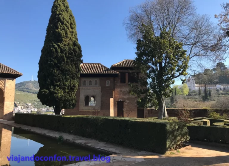
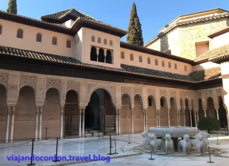
Desde el patio de Lindaraja accedemos al Partal. Atravesando unos pequeños jardines con vistas al Sacromonte llamados Patio de la Higuera.
Esta entrada desemboca a la explanada donde nos encontramos el precioso pórtico del Palacio del Partal. Este preside los hermosos jardines del recinto con su gran alberca al frente.
Tras sus cinco pórticos se encuentra la sala principal en el interior de la torre llamada Torre de las Damas. Junto a esta encontramos el «observatorio», un precioso mirador característicos de otras construcciones nazaríes, como el Palacio de Comares.
Se construyó en tiempos del Sultán Muhammad III (1302-1309) siendo el palacio más antiguo que se conserva en la Alhambra. Además, destaca por ser el único palacio que no ha sufrido ninguna reestructuración a lo largo de la historia.
El Palacio del Partal se incorporó al Conjunto de la Alhambra en 1891. Fue tras la cesión al estado de su entonces propietario Arthur Von Gwinner.
A su lado encontramos, dirección a la Meca, el pequeño Oratorio del Partal. Construido durante el reinado de Yusuf I (1333-1354) para favorecer la meditación del Sultán sobre la identidad de la naturaleza, la Creación y la oración.
Oratorio
Oratorio.
Al otro lado del palacio encontramos las Casas Nazaríes, un grupo de casas construidas en el siglo XIV. Son cuatro casas conocidas como casa de González Pareja, casa de Villoslada, Casa de los Balcones y casa de las Pinturas, independientes entre sí.
Casas Nazaries.
Si subimos por las primeras escaleras a mano derecha, nos topamos con el Rawda o Rauda, que significa cementerio. Un edificio de planta cuadrangular a espaldas del Palacio de los Leones. Aquí la familia real enterraba a sus familiares difuntos. Fue hasta que Boabdil se llevó a todos sus antepasados al castillo de Mondújar tras abandonar la Alhambra.
Puerta de la Rauda
En el centro de los jardines, a media altura se encuentra la Casa Contigua al Palacio del Partal Alto. Es una casa que presenta una estructura similar a las edificaciones nazaríes. Está dotada de amplias habitaciones abiertas a un patio central alrededor de una alberca.
Lo que vemos es una réplica de la original de 2008 ya se trasladó a los almacenes del museo de la Alhambra debido a su deterioro, para ser restaurada y conservada.
Casa Contigua al Palacio del Partal Alto.
Desde aquí podemos disfrutar de unas maravillosas vistas del Palacio del Partal.
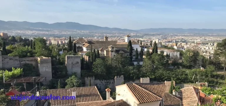
Paseo de las Torres
Seguimos paseando por los jardines del Partal hasta llegar a la muralla. Allí nos encontramos la Torre de los Picos, que servía para defender la Puerta del Arrabal. Se construyó a finales del siglo XIII o principios del XIV.
Es conocida así por unos elementos con forma de ménsulas que sobresalen en la cara exterior de la planta alta. Estos servían como balcones volados para, desde arriba, controlar toda la vertical de la torre y de la planta situada en su base.
Torre de los Picos
El Generalife desde el paseo de las Torres.
Seguimos la ronda de la muralla. Recibe el nombre de Paseo de las Torres, nos encontramos un poco más adelante con la Torre del Cadí. Más adelante, la Torre de la Cautiva.
La Torre de la Cautiva era conocida como Torre de la Ladrona en el siglo XVI y más tarde de la Sultana. Luego se le cambió el nombre al actual porque se cree que la habitó Doña Isabel de Solís. Esta fue convertida al Islam con el nombre de Zoraya, favorita del rey Muley Hacén.
Torre del Cadí y detrás la de la Cautiva
Un poco más adelante nos topamos con la Torre de las Infantas. Quizá, la torre más famosa de todas. Ésta es similar a la Torre de la Cautiva. Aunque su decoración expresa en general un momento de decadencia que coincidiría con el cambio del siglo XIV al XV. Concretamente a la época del sultán Muhammad VII (1392-1408).
Esta torre es escenario de la famosa leyenda de las tres princesas, Zaida, Zorayda y Zorahaida. Está recogida por Washington Irving en sus famosos Cuentos de la Alhambra.
Seguimos un poco más y nos topamos con la Torre del Cabo de la Carrera, llamada así por ser el límite de la calle Mayor de la Alhambra. La torre fue restaurada en 1502 por orden de los Reyes Católicos pero destruida por el ejército de Napoleón en 1812 cuando abandonaban la ciudad. Hoy solo se conservan sus restos.
Junto a las ruinas encontramos el acceso a los jardines del Generalife, aunque de momento no entraremos y seguiremos por la ronda, tomando el Camino Real de la Alhambra.
Pasado el acceso al Generalife llegamos a la Torre del Agua, conocida así por encontrarse junto al acueducto que conduce el agua del Generalife a la Alhambra.
Originalmente era una gran torre de tres plantas sólo quedan los restos ya que también fue dinamitada por las tropas de Napoleón en 1812. El resto de la Alhambra no corrió la misma suerte gracias a José García, cabo de inválidos que cortó las mechas encendidas entre la Torre de la Carrera y la de las Infantas.
Torre del Agua y el acueducto a su lado.
Tras pasar el acueducto, entramos en los restos de la medina donde encontramos la Torre de Juan de Arcela y un poco más adelante la Torre de Baltasar de la Cruz.
Seguimos caminando y llegamos a la Puerta de los Siete Suelos. Ésta fue la entrada más importante de todo el recinto de la Alhambra. En principio fue llamada como Bib «al-Gudur» o Puerta de los Pozos por los musulmanes debido a las mazmorras que existían en los campos situados frente a la torre usados para confinar presos.
Se cree que fue por la que salió el derrotado Rey Boabdil y entregó la Alhambra a los Reyes Católicos, pidiéndoles que nadie volviese a atravesar la puerta, cerrándola para siempre.
Su nombre actual viene de la creencia que afirma la existencia de siete pisos subterráneos bajo el baluarte que la defiende, aunque realmente solo se conocen dos.
Al otro lado de la calle se encuentran los Jardines de San Francisco y tras estos, el Convento de San Francisco. Se construyó en 1494 por orden de los Reyes Católicos sobre el palacio nazarí de los Infantes de Muhammad III. En su capilla fueron enterrados por primera vez Isabel y Fernando hasta que Carlos I de España ordenó al conde de Tendilla que los trasladara a la Capilla Real, donde siguen enterrados hoy día.
En 1835 los franciscanos abandonan el convento. Éste tiene durante años varios usos incluyendo un cuartel militar hasta que el arquitecto Leopoldo Torres Balbás lo reconstruye desde casi una ruina entre 1927 y 1936.
En 1945 se inaugura aquí el Parador de Turismo perteneciente a la red de Paradores Nacionales de Turismo.
Jardines de San Francisco y el convento.
Un poco más adelante nos encontramos con las ruinas de la Torre de los Abencerrajes, una pequeña torre defensiva, que el ejército de Napoleón dinamitó en 1812. Junto a ella se encuentran las ruinas del Palacio de los Abencerrajes, un parque arqueológico en el lugar donde se encontraba el palacio adosado a la murallas junto a la Torre de los Abencerrajes.
En 1501 los Reyes Católicos ceden el palacio don Juan Chacón, Adelantado de Murcia, y contador mayor del Real Consejo. A partir de entonces, el palacio pasa a denominarse Palacio de la Contaduría.
Aquí se encuentra uno de los accesos al recinto de pago de la Alhambra.
Si salimos y seguimos la calle pronto nos encontramos con los baños de la mezquita, construido para dotar a la Mezquita Aljama que se encontraba donde hoy se encuentra la Iglesia de Santa María de la Alhambra.
Fueron construidos en la época del sultán Muhammad III (1302-1309). Más tarde fueron transformados en viviendas. En el siglo XIX vivió aquí el guitarrista Antonio Barrios, con los que fue denominada «Casa del Polinario».
Hoy en día es un museo dedicado a su hijo, el músico y compositor Ángel Barrios.
Baños de la mezquita
Iglesia de Santa María de la Alhambra
Disfruta de una fabulosa visita guiada a la Alhambra con Civitatis.
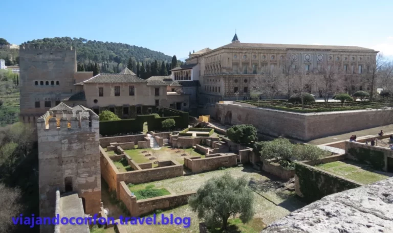
La Alhambra es un complejo monumental situado en la ciudad de Granada, Andalucía. Se trata de un conjunto de antiguos palacios, jardines y fortaleza construido para alojar a la corte del Reino Nazarí (1238-1492) y, tras la reconquista, para la realeza castellana.
Su rica decoración interior es de las más importantes del arte y arquitectura andalusí y alberga el museo de arte andalusí. Está gestionado por el Patronato de la Alhambra y el Generalife y en 2016 fue el segundo monumento más visitado de España después de la Sagrada familia de Barcelona. Antes de la pandemia lo visitaban una media de casi 3 millones de visitantes al año.
En esta entrada vamos a narrar en forma de diario nuestro primer viaje a Francia. Visitaremos París y las zonas de Picardía y Normandía centrándonos sobre todo en los cementerios de las Guerras Mundiales.
Una vez más, a causa de la pandemia de Covid-19, volvemos a aplazar nuestro viaje de verano a tierras asiáticas. El año pasado Laos y este año iba a ser nuestro tercer viaje a Japón. Pero seguimos conociendo bellos rincones de España.
Toca viaje largo. A las 8.55 de la mañana despegamos puntuales hacia el aeropuerto de Barcelona, donde haríamos una escala de 8 horas.
Con esta escala tan larga decidimos ir a dar un pequeño paseo por Montjuïc. Para ello tomamos el Aerobus 1 y nos bajamos en la Plaza de España. El billete de ida cuesta 5.90€ y el de ida/vuelta 10.20€.
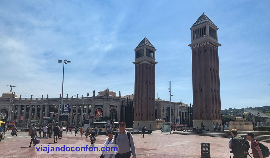
La Plaza de España (Plaça d’Espanya) fue construida en 1929 para la Exposición Internacional. Fue según los planos de los arquitectos Josep Puig i Cadafalch y Guillem Busquets.
En la plaza podemos ver varios elementos reseñables como la fuente monumental diseñada por Josep Maria Jujol y con la decoración monumental confeccionada por Miguel Blay y los hermanos Miquel y Llucià Oslé.
También encontramos la Plaza de Toros Las Arenas. Construída en el año 1900 en estilo neomudéjar por el arquitecto Augusto Font Carreras. El 19 de junio de 1977 se celebró la última corrida de toros y, a partir de ahí estuvo prácticamente en deshuso hasta el año 2011 en el que se reconvirtió en centro comercial.
Fuente y Plaza de Toros
En la entrada de la avinguda de la Reina María Cristina encontramos las Torres Venecianas, construidas en 1929 por el arquitecto Ramon Reventós como puerta de acceso a la Exposición Internacional de ese año. Su nombre se debe a su parecido con el campanile de San Marcos en Venecia.
Subiendo por la avinguda de la Reina María Cristina encontramos la Feria Internacional de Barcelona y el Palacio de Congresos de Barcelona.
Al final de la avenida llegamos a la Font Màgica de Montjuïc (Fuente Mágica de Montjuic) construida con motivo de la Exposición Internacional de 1929 por Carles Buïgas en el lugar donde estaban situadas las Cuatro Columnas de Josep Puig i Cadafalch.
La música se incorporó durante los años 80 y fue completamente restaurada antes de los juegos olímpicos de 1992. La fuente es un conjunto de juegos de luz y agua que se desarrolla en todo el eje desde el Palacio Nacional hasta la plaza de España, que incluye cascadas y estanques.
Al final de las escaleras (la mayor parte mecánicas pero no todas) llegamos al impresionante Palacio Nacional de Montjuic, construido entre 1926 y 1929 para la Exposición Internacional de 1929 de Barcelona y que desde 1934 aloja el Museo Nacional de Arte de Cataluña.
Fue obra de los arquitectos Eugenio Cendoya y Enric Catà, bajo la supervisión de Pere Domènech i RouraFue y se trataba del edificio principal de la Esposición Internacional.
Desde aquí tenemos unas vistas espectaculares de la ciudad de Barcelona.
Tras el palacio se encuentra L’Anella Olímpica de Montjuïc, el Anillo Olímpico, las instalaciones deportivas del los juegos de 1992. En él encontramos el mítico Estadio Olímpico Lluís Companys.
El estadio fue inaugurado el 20 de mayo de 1929 por el rey Alfonso XIII. Entre 1985 y 1989 fue reconstruido casi en su totalidad para prepararlo para los Juegos Olímpicos.
Estadio Olímpico Lluís Companys y pebetero olímpico
Aquí también se encuentra el Palau Sant Jordi, construido para los Juegos Olímpicos por arquitecto japonés Arata Isozaki. Por desgracia todo el recinto se encontraba cerrado por obras y tuvimos que verlo de lejos.
También encontramos el Castell de Montjuïc (Castillo de Montjuic), una antigua fortaleza militar que inicialmente fue una pequeña atalaya para vigilar el tránsito marítimo que fue evolucionando a lo lardo de los siglos hasta llegar al aspecto que observamos hoy día.
Ya a la bajada nos encontramos con los jardines Joan Maragall, rodeando el Palacete Albéniz residencia de la familia real española durante sus visitas a la ciudad condal.
Palacio Nacional de Montjuïc
También se encuentra aquí el Poble Espanyol (Pueblo Español) un museo arquitectónico al aire libre. Se inauguró en 1929 para la Exposición Internacional tras la idea del arquitecto catalán Josep Puig i Cadafalch y se concibió como un pueblo en el que se pretendían reunir las principales características de los pueblos de España.
Como ya se hacía la hora de comer, buscamos algún sitio recomendable. Elegimos El Mesonet, un sencillo restaurante de gastronomía catalana. Comimos de maravilla (el arroz montañés fue delicioso) y bastante barato.
De camino a la parada del bus pasamos por la Plaza de Toros Las Arenas. Desde la terraza podemos obtener unas vistas espectaculares.
Ahora si, toca volver al aeropuerto para poner rumbo a nuestro destino real: Islandia.
Si dispones de más tiempo, siempre puedes disfrutar de alguna de las múltiples actividades que te propone Civitatis en Barcelona:
En nuestro periplo por tierras Lituanas hoy mudamos el campamento y nos vamos hasta Klaipeda.
Klaipėda es la tercera ciudad más poblada de Lituania y el principal puerto marítimo del país, situado en la costa del mar Báltico.
Como siempre, recomendamos el seguro de viaje de IATI, especialistas en seguros de vieja. Además, por ser nuestro lector, obtendrás un 5% de descuento en la contratación de tu seguro:
La ciudad se funda en 1252 por la Órden Teutónica. Entonces es llamada Castrum Memele (en alemán Memelburg) y siendo cristianizada toda el área.
La Paz del Mar Melno en 1422 fijó la hermandad entre la provincia de Prusia y Lituania. Memel se incluyó en Prusia y la frontera permaneció inalterada hasta 1919. Fue una de las fronteras más largas sin cambios en Europa.
A comienzos de 1474 Memel fue gobernada por la Ley Culm de las ciudades prusianas.
En 1525, el Ducado de Memel adoptó el luteranismo bajo el reinado de Alberto de Prusia. Fue el comienzo de un largo periodo de prosperidad para la ciudad y el puerto. Ya que el Ducado de Prusia fue un feudo polaco y más tarde parte de la Comunidad de naciones Polaco-Lituana. Esa prosperidad llegó a su final cuando, entre 1629 y 1635, Memel fue atacada y ocupada por Suecia.
Con la creación del Estado unificado alemán en 1871, Memel se convirtió en la ciudad más al noreste de Alemania. Tras el Tratado de Versalles el territorio que rodeaba a Memel es separado de Alemania y recibe una autonomía bajo ocupación francesa.
En 1923 tropas lituanas bajo el mando del coronel Budrys atacaron la ciudad y los franceses se retiraron.
Memel fue reabsorbida por el Reich alemán el 22 de marzo de 1939, tras la anexión de Austria, los Sudetes y Checoslovaquia. En enero de 1945 la ciudad es capturada por el Ejército Rojo y entregada a Lituania.
1 de agosto
A las 11.35 salió el bus desde la estación de Vilnius. Durante el trayecto sucedió algo que me dejo impresionado. En cierto momento por la autopista, adelantamos a un viejo coche que iba remolcado por un seat Ibiza medienta una cuerda normal y corriente, atada al parachoques. Esto en España te pillan y te meten un paquete que te cagas.
Algo menos de 4 horas más tarde llegábamos a la estación de Klaipėda. Desde aquí nos fuimos dando un paseo hasta nuestro hotel, el National Hotel. Un hotel de 4 estrellas muy céntrico y bastante barato.
Encuentra el mejor hotel al mejor precio en Klaipeda con Agoda:
Dejamos las cosas y nos fuimos a dar un paseo por el casco antiguo de la ciudad. La parte central del barrio parece un típico pueblecito alemán. ¿Habremos cambiado de país sin darnos cuenta?
El sitio más céntrico es Teatro Aikštė, la Plaza del Teatro. Esta es la plaza central del casco antiguo de Klaipeda.
En un principio aquí se encontraba parte de los fosos del castillo. Tras ser rellenado en 1819, se abre un mercado en este lugar. Este mercado va evolucionando y creciendo a medida que pasan los años.
El edificio más reseñable de la plaza es (obviamente) es el teatro. Se desconoce el momento de la construcción del primer edificio. Según unos planos de la ciudad del siglo XVIII, aquí se encontraba un edificio de planta cuadrada llamado “Komedijų namais” (Casa de la Comedia). Anteriormente era un edificio militar.
El nuevo auge de la vida teatral en Klaipėda comenzó después de 1818, cuando llegó aquí el alemán Ulbrich. Una empresa de comercio forestal le permitió el uso gratuito de un edificio temporal de madera, donde instaló una sala de 200 asientos y abrió un teatro.
Teatro Aikštė
A fines del siglo XIX, se completó la construcción de un nuevo teatro. Era de ladrillo de estilo clasicista de dos plantas con buhardilla en el sitio del teatro actual. En 1854 el teatro se quema durante un incendio en la ciudad pero se reconstruye en 1857.
Para 1935 se traslada a Klaipeda el Teatro Šiauliai, una ciudad a 170 km al oeste. Funciona como Teatro Estatal de Klaipeda hasta 1939.
Por desgracia, durante nuestra visita estaba totalmente tapado. Estaban realizando obras de restauración y no pudimos contemplarlo.
Otro elemento reseñable de la plaza es el monumento a Simon Dach. Poeta nacido en 1605 en Klaipeda cuando oficialmente se llamaba Memel y pertenecía a Alemania. Se trata de una fuente instalada en 1912 cuya escultura representa a la joven descalza. Es uno de los personajes creado por el poeta.
En 1939 la escultura fue retirada de la plaza y se dice que la idea era sustituirla por una de Adolf Hitler. Para 1989 se vuelve a instalar una réplica de la escultura original.
Desde aquí nos fuimos a la ribera del río Danés. Cruzamos el río por el puente Biržos. Hasta el siglo XVIII, el entonces puente de madera, además de para cruzarlo, servía para cobrar tributo a todos los barcos que quisieran pasar elevándolo.
En 1877 se inicia la construcción de un nuvo puente de acero diseñado por el ingeniero Bernstein de Wiesbaden. Se inaugura en 1879.
Para 1904 se rediseñó la parte superior para que pudieran circular por el los nuevos tranvías de la ciudad. En dicha reconstrucción el puente fue decorado con dos portales Art Nouveau calados de metal a los que se adosaron farolas.
Destruido durante la Segunda Guerra Mundial, se reconstruyó con el mismo diseño en 1948. La última restauración es de 2007.
Biržos tiltas
La ciudad debía estar en fiestas. En el parque junto al río habían varios puestecillos de comida y artesanía. Allí nos sentamos a tomar unos refrescos y comer kepta duona. Es una especie de tiras de pan frito con queso, que está buenísimo (Receta aquí).
Junto al puente encontramos Arka, un monumento construido por el escultor Arūnas Sakalauskas en 2003. Fue para conmemorar el 85 aniversario de la Ley de Tilsit y el 80 aniversario de la revuelta de Klaipėda.
La columna roja más pequeña está hecha de granito rojo y simboliza Lituania Menor y su herencia cultural. Mientras que la parte gris simboliza la Lituania propiamente dicha. La parte gris en la parte superior parece haberse roto y representa el Óblast de Kaliningrado, actualmente parte de Rusia.
La inscripción de la parte superior que dice: “Esame viena tauta, viena žemė, viena Lietuva” (“Somos una nación, una tierra, una Lituania”) son unas palabras de la escritora lituana Ieva Simonaitytė.
Desde aquí nos fuimos a descansar un poco pero, de camino, pasamos por un supermercado para comprar algo de cenar. Por 18.84 Litas (5.45€) compramos un montón de cosas.
Tras el descanso dimos un pequeño paseo nocturno pero nos fuimos temprano a la cama que había que madrugar muchísimo. El día siguiente iba a ser duro, muy duro.
2 de agosto
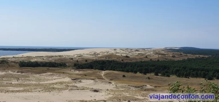
Madrugamos mucho no, muchísimo. Hoy visitamos el istmo de Curlandia, un istmo de arena que separa el mar Báltico de la Laguna de Curlandia. Tiene una longitud de 98 km de los cuales 52 pertenecen a Lituania y el resto al Oblast de Kaliningrado en Rusia.
Según la mitología báltica, el istmo fue formado por una chica muy fuerte llamada Neringa que estaba jugando en la playa.
Laguna de Curlandia
Toda la parte lituana pertenece al municipio de Neringa. Hasta la reforma del municipio lituano de 2000, se conocía como la ciudad de Neringa, aunque nunca hubo allí una verdadera “ciudad”. Se convirtió en una ciudad en la Unión Soviética en 1961 al combinar formalmente 4 asentamientos en una unidad administrativa.
A las 7.20 de la mañana estábamos tomando el transbordador de Klaipeda a Smiltynés. El trayecto nos costó 2.90 Litas (0.85€) y tarda unos 20 minutos en cruzar la laguna. Desde aquí nos subimos un bus que nos llevó hasta Nida. El trayecto nos costó 11 Litas (3.20€) y dura algo más de una hora.
Nida es la capital administrativa del municipio de Neringa y es muy conocido como destino turístico y por la colonia de artistas de Nida. Fue un movimiento artístico importante en Prusia Oriental que comenzó alrededor de 1890 y finalizó con el comienzo de la Segunda Guerra Mundial.
Nida es es el punto más occidental de Lituania y los estados bálticos. Está cerca de la frontera con el enclave ruso del Oblast de Kaliningrado y cuenta con unos 2.300 habitantes.
Nida
Aquí compramos un snack para el camino y nos fuimos hacia un punto de alquiler de bicicletas que tenía ya fichado. Las bicis nos costaron 30 Litas (8.70€) cada una y podíamos devolverlas en cualquiera de los puntos que tenían a lo largo de todo el istmo.
Con las bicis nos dirigimos al primer punto que queríamos ver, la Parnidžio kopa, la duna Parnidis o la Gran Duna de Nida. Una duna de arena en movimiento de 52 metros de altura y se cree que su nombre, Parnidis, proviene de la frase cuyo significado es “pasó por Nida” porque esta duna arrastrada por el viento ha pasado varias veces por el pueblo de Nida.
Se puede subir a lo alto pero solo por los caminos marcados. Está estrictamente prohibido salirse de éstos para asegurar su conservación.
Aparcamos las bicis y subimos las escaleras por medio del frondoso bosque que lleva a lo alto y podemos admirar las impresionantes vistas.
En lo alto de la duna se encuentra Saulės laikrodis, un reloj de sol de granito construido en 1995. En 2011 tuvo que ser restaurado ya que fue destruido durante una tormenta. El reloj de sol es un pilar de piedra de 13,8 metros de altura y un peso de 36 toneladas. Desde el punto de vista astronómico, la duna de Parnidis es un lugar ideal para el reloj de sol en Lituania.
Saulės laikrodis
Después de admirar las espectaculares vistas nos pusimos en camino, dirección norte, hacia donde se encontraba el ferry, aunque no íbamos a llegar tan lejos. Prácticamente todo el camino lo pudimos hacer a través de carril bici. Es una maravilla ya que no te encuentras con tráfico y no te pones en peligro
La siguiente parada fue Vecekrugo kopa, la duna Vecekrugo a unos 8 km de Nida. Esta es la duna más alta de todo el istmo de Curlandia con 67 metros de altura. A ella se puede subir también por el camino marcado para admirar las vistas. Pero la verdad es que son menos impresionantes que las de la Duna Parnidis.
Vecekrugo kopa
Aquí aprovechamos para descansar un poco a la sombrita y comernos lo que habíamos comprado en Nida. Tras el descanso volvimos al camino. Tras kilómetros de un paisaje espectacular combinando bosque y costa, llegamos a la ciudad de Pervalka, a unos 8 km de Vecekrugo kopa.
Pervalka es una (muy) pequeña población de unos 200 habitantes. La mayoría de casas son pequeñas construcciones de pescadores de finales del siglo XIX y principios del XX y la mayoría se encuentran a ambos lados de la calle principal a lo largo de las orillas de la laguna de Curlandia.
La verdad es que el pueblo es encantador. Si un día me toca la lotería, me compro una casita de veraneo aquí.
Aquí compramos en una tiendecilla algo para comer, ligerito para seguir dando a los pedales. Seguimos paseando hasta llegar a la costa del mar Báltico. Concretamente a Juodkrantės bendras paplūdimys, la playa de Juodkrantės, a unos 17 km de Pervalka. Una espectacular playa de arena fina y blanca en la que daba unas ganas tremendas de despelotarse y meterse en el mar, que hacía mucho calor aquel día.
Ya desde aquí nos dirigimos a Juodkrantė (literalmente costa negra), un pueblo turístico con unos 700 habitantes. Situado en el territorio de la antigua Prusia, fue durante siglos un pueblo de pescadores llamado Schwarzort, que experimentó un auge turístico a finales del siglo XIX y principios del XX.
Aquí devolvimos las bicis, en el muelle del pueblo y allí mismo nos subimos al bus para ir hasta el ferry. Llegamos al hotel sobre las 7 de la tarde y descansamos un poco antes de ir a por algo de cena.
El descanso se nos fue un poco de las manos y se nos hizo algo tarde.
Por internet había fichado un sitio para cenar y nos pusimos en camino. Tras caminar largo rato llegamos a la Klaipeda soviética: anchas avenidas y bloques enormes de viviendas. Por ese camino no había nada y la iluminación no daba para mucho. Como no encontrábamos el sitio decidimos darnos la vuelta y buscar algo en el casco antiguo. Con tan mala suerte que se había hecho demasiado tarde y ya no nos dejaron entrar a ningún restaurante (cierran a las 22.00). Así que decidimos comprar algo de comida preparada en un supermercado y comerlo tranquilamente en el hotel.
3 de agosto
Últimas horas en Klaipeda. Dimos un paseo por el casco antigo hasta llegar a las ruinas del castillo, Klaipėdos Pilis. El castillo de Klaipeda también conocido como Memelburg o Castillo de Memel fue construido por los Caballeros Teutónicos . Se desconoce el año de su construcción pero fue mencionado por primera vez en fuentes escritas en 1252 y sufrió numerosas destrucciones y reconstrucciones en los siglos siguientes.
Durante el siglo XIX, habiendo perdido su importancia estratégica, el castillo fue demolido. Se realizaron trabajos arqueológicos en el sitio durante el siglo XX, y en 2002 se estableció un museo debajo de uno de sus baluartes. Actualmente, el castillo está siendo restaurado.
Hay que decir que no nos dio tiempo de visitar el museo.
Restos de la muralla del castillo.
En el muelle se encuentra la escultura más… extraña o perturbadora que recuerdo haber visto: Klaipėdos Juodasis vaiduoklis o el fantasma negro de Klaipeda, una figura fantasmal encapuchada trepa desde el agua, sosteniendo una linterna en su mano.
Tan perturbadora escultura está relacionada con una leyenda que se remonta a 1595 cuando Hans von Heidi, uno de los guardias del castillo de Klaipėda, hacía sus rondas nocturnas cerca del puerto.
De la nada, una figura encapuchada apareció cerca de la orilla del agua. En lugar de atacar al guardia sobresaltado, le preguntó cómo estaban resistiendo los suministros de grano y madera de la ciudad. Von Heidi le informó al fantasma que la ciudad tenía suficientes suministros, pero el fantasma le advirtió que no sería suficiente. En ese momento, la aparición se desvaneció.
En los viejos tiempos, por supuesto, la gente se inclinaba a creer las palabras de fantasmas, brujas, duendes y gigantes. Y así, Hans von Heidi informó obedientemente a sus superiores de su encuentro fantasmal, y la ciudad se dispuso a aumentar sus suministros de madera y grano. Luego siguieron unos años sombríos de hambre y escasez, a los que la gente de Klaipėda solo sobrevivió gracias a la advertencia del fantasma.
En 2010 se instaló la escultura, obra Svajunas Jurkus y Sergejus Plotnikovas y y rinde homenaje al fantasma salvador de la ciudad.
Aquí damos por finalizada nuestra visita a Klaipeda y Neringa. Tocaba volver a la estación a tomar el bus a un nuevo destino: Kaunas.
Aquí les dejamos un mapa con los puntos visitados en este viaje:
Encuentra actividades interesantes para hacer en Klaipeda y Neringa con Civitatis:
Este año buscábamos un destino “exótico”, un destino poco visitado por españoles y lo conseguimos. Viajamos a Lituania, empezando por su capital: Vilnius.
29 de Julio
Para ello tuvimos que ir a Málaga, donde tomamos un vuelo con Ryan Air hasta Barcelona.
Despegamos puntuales a las 8.50 de la mañana. En algo menos de 2 horas ya estábamos en el aeropuerto del Prat. Paseo por aquí, bocata por allá y cambio de moneda por otro lado. A las 16.30 despegábamos rumbo de Vilnius, la capital de Lituania.
Recuerda viajar siempre con seguro de viaje. Con IATI, especialistas en seguros de viajes, tienes un 5% de descuento por ser nuestro lector.
Cabe reseñar que hasta 2015 funcionó su moneda nacional: el Litas. Fue a partir de ahí que empezó a circular el Euro.
A las 21.05 aterrizábamos en Vilnius. Salimos del aeropuerto y tomamos el tren hasta la estación central. Desde aquí nos separaban unos 10 minutos hasta el hotel.
Elegimos el Europa Royale Vilnius, un hotel bastante céntrico de 4 estrellas que nos costó 66€ la noche con desayuno.
Encuentra el mejor hotel al mejor precio en Vilnius con Agoda.
*Nos ayuda a mantener el blog
Cenamos algo en una pizzeria cercana: Charlie Pizza, que es una cadena, y nos fuimos a descansar para madrugar.
30 de Julio
Madrugamos, desayunamos y nos fuimos a conocer la ciudad. De momento llueve a ratos.
Muy cerca del hotel, de camino al centro, llegamos primero a la Plaza del Ayuntamiento (Rotušės aikštė). En ella encontramos (lógicamente) el edificio del ayuntamiento (Vilniaus rotušė). El ayuntamiento de Vilnius se mencionó por primera vez en 1432. Inicialmente era un edificio de estilo gótico y desde entonces ha sido reconstruido muchas veces.
El edificio actual data de 1799. Está construido en estilo Neoclásico según planos del arquitecto lituano Laurynas Gucevičius, aunque aún se conservan las bodegas góticas más antiguas.
Seguimos bajando dirección catedral. A pocos metros de la plaza del ayuntamiento nos encontramos con la iglesia ortodoxa Šv. kankinės Paraskevės cerkvė (Mártir Paraskevės). Es la iglesia ortodoxa oriental más antigua del país y una de las dos únicas iglesias ortodoxas que hablan en lituano.
La primera iglesia se construyó donde se encontraba un templo pagano a petición de María Yaroslavna de Vitebsk. Fue la primera esposa del Gran Duque Algirdas y fue enterrada aquí tras su muerte en 1346.
La iglesia quedó completamente destruida por un incendio en 1557. Se reconstruyó tres años después, pero se incendió nuevamente en 1611. Estando en ruinas, fue entregada a los católicos orientales locales. En 1655, fue devuelta a la Iglesia Ortodoxa y renovada.
Durante la Gran Guerra del Norte, en 1705, con Vilna invadida y saqueada por el ejército moscovita, la iglesia fue visitada por el zar ruso Pedro el Grande, quien rezó allí por la victoria militar.
En 1748, el edificio quedó nuevamente destruido por un incendio y reconstruido en 1795. Sin embargo, permaneció cerrado durante los siguientes cuarenta años, cayendo lentamente en decadencia. En 1864, por orden del gobierno local ruso, Nikolay Chagin la reconstruyó en estilo neobizantino.
Durante la Segunda Guerra Mundial volvió a quedar destruida. Se reconstruyó rápidamente pero el gobierno Stalinista prohibió que se celebraran los cultos ortodoxos. Entonces se convirtió en una galería de arte hasta que en 1990 fue devuelta a la iglesia ortodoxa.
Aquí empieza (o mejor dicho acaba) Pilies Gatvé (calle Pillies) una de las calles principales del casco antiguo de Vilnius. Es una calle muy animada llena de restaurantes, terrazas y tiendas. El sitio ideal para comprar tus recuerdos.
Torre Gediminas desde Pillies Gatvé
Recorremos toda Pillies y llegamos hasta la Plaza de la Catedral (Katedros aikštė). Aquí encontramos varios elementos destacables, empezando por la Catedral de Vilnius (Vilniaus katedra).
Catedral de Vilnius.
La Catedral de San Estanislao y San Ladislao es la principal catedral católica romana de Lituania.
Fue el Rey Mindaugas quien ordenó su construcción en el año 1251. En este lugar se adoraba en época precristiana al dios pagano báltico Perkūnas. Es el dios del trueno, la lluvia, las montañas, los robles y el cielo.
Tras la muerte de Mindaugas en 1263, el templo volvió a ser un lugar de culto a Perkūnas.
En 1387, año en que Lituania se convierte oficialmente al cristianismo, empieza la construcción de una segunda catedral gótica. Es devorada por un incendio en 1419.
Durante los preparativos para su coronación como rey de Lituania en 1429, Vytautas construye otra catedral gótica más grande en su lugar. Aunque dicha coronación nunca tuvo lugar, aun se conservan los muros y los pilares.
En 1522, se renovó la catedral y se construyó un campanario sobre la torre defensiva del Castillo Inferior.
Tras otro incendio en 1530, se reconstruyó de nuevo y entre 1534 y 1557 se añadieron más capillas y criptas. La catedral adquirió rasgos arquitectónicos asociados al Renacimiento.
El edificio actual se construyó en estilo neoclásico entre 1779 y 1783 según el diseño del arquiteco lituano Laurynas Gucevičius.
Durante el régimen soviético, la catedral se convirtió en un almacén. En 1988 se volvieron a celebrar misas.
Encuentra multitud de actividades y tours en Vilnius y Lituania en Civitatis.
*Nos ayuda a mantener el blog
Lo que más nos llamó la atención fue el campanario, separado del resto del edificio. Se construyó en el siglo XIII y era originalmente una torre defensiva del castillo medieval. Su imagen actual se debe a principios del siglo XIX y alberga el reloj más antiguo de Lituania.
En la plaza también encontramos el monumento al Gran Duque Gediminas, construido en 1996 por Vytautas Kašuba.
Gediminas gobernó entre 1315 y 1341 el Gran Ducado de Lituania. Hoy ocuparia Lituania, Bielorrusia, Ucrania y Moldavia, así como Podlaquia en Polonia y Smolensk, Briansk y Kursk hoy en Rusia.
Tras la catedral se encuentra el Palacio de los Grandes Duques de Lituania. Construido en el siglo XV para los gobernantes del Gran Ducado de Lituania y los futuros reyes de Polonia. Se construyó en el castillo inferior de Vilnius. Fue reformado y ampliado durante los siglos XVI y mediados del XVII.
Tras la invasión rusa de 1655 el palacio quedó gravemente dañado y sus tesoros y objetos de valor saqueados. Después de la reconquista de la ciudad en 1661 el palacio quedó abandonado durante 150 años.
Lo poco que quedaba del palacio se destruyó en 1801. Fue tras la incorporación del Gran Ducado de Lituania al Imperio Ruso.
El edificio actual es una reconstrucción igual al original llevada a cabo entre el año 2000 y 2013. Aunque se inauguró oficialmente en 2009. Por lo que no era visitable cuando nosotros estuvimos.
Hoy en día alberga el Museo Nacional de Lituania.
Palacio de los Grandes Duques de Lituania.
Frente a la fachada principal de la Catedral, encontramos la baldosa que dice Stebuklas (“milagro” en lituano) también conocido como Ladrillo Mágico. Se colocó para conmemorar la cadena humana que recorrió las tres repúblicas bálticas en 1990. Fue para pedir la independencia de la URSS.
Desde su colocación se convirtió en una atracción para los transeúntes.
Durante un tiempo después fue posible observar formas alternativas de interpretarla. La gente pensó que la baldosa era un lugar para formular deseos, pero no sabían lo que había que hacer. Algunos pisan la baldosa y giran sobre su eje, otros saltan sobre ella.
Desde aquí nos fuimos de camino a la Torre Gediminas. Para ello íbamos a usar el funicular por falta de ganas de subir andando.
Bordeamos la catedral dirección norte pasando por la entrada del que era en ese momento el Museo Nacional de Lituania. Hoy sigue siendo parte de él.
El museo se funda en 1952 y abarca una amplia colección de artefactos y materiales escritos. También organiza excavaciones arqueológicas en Lituania.
Su predecesor fue Museo de Antigüedades de Vilna, fundado por Eustachy Tyszkiewicz en 1855. Aunque en su origen, el museo se centraba en la cultura e historia del Gran Ducado de Lituania.
A parte de en el recién reconstruido Palacio de los Grandes Duques de Lituania, también ocupa el nuevo arsenal del Complejo de castillos de Vilna.
Dentro del recinto del arsenal se encuentra el Funicular para subir a la torre (Keltuvas į Gedimino kalną). Nos costó 2 LT (0.57€). El trayecto dura apenas 1 minuto.
El funicular te deja junto a la Torre Gediminas (Gedimino pilies bokštas). Forma parte de los restos del antiguo castillo de Vilnius.
Originalmente el castillo era una fortificación de madera. Fue el Gran Duque de Lituania Gediminas el que construyó el primer castillo de ladrillos, finalizado en 1409.
La torre actual se debe a una reconstrucción de 1933.
La Torre de Gediminas es un importante símbolo estatal e histórico de la ciudad de Lituania. Fue desde donde se izó la bandera lituana el 7 de octubre de 1988, durante el movimiento de independencia. Este finalizó con la Ley de Restablecimiento del Estado de Lituania el 11 de marzo de 1990.
Sobre el castillo pesa una leyenda que dice así:
Hace mucho tiempo, el gran duque lituano Gediminas cazaba en los bosques del valle de Šventaragis. La caza tuvo éxito y el duque Gediminas derribó un toro salvaje en la cima de una colina; pero sus miembros se cansaron, por lo que el duque se retiró y pasó la noche allí.
Entonces Gediminas soñó que, en la cima de la misma colina donde había estado cazando ese día, estaba parado un gran lobo hecho de hierro, y estaba aullando tan fuerte como si fueran cien lobos.
El duque le pidió al mago de la corte, Lizdeika, que le explicara su sueño. Él lo interpretó así: se trataba de un presagio que indicaba que debía construir una ciudad en este lugar, que más tarde sería conocida en todo el mundo y se convertiría en la magnífica capital de Lituania.
Gediminas, obedeciendo la voluntad de los dioses, comienza a construir la futura ciudad capital y un castillo en el centro de la misma. La ciudad fue nombrada Vilnius por el cercano río Vilnia. La Torre de Gediminas es la única parte sobreviviente de ese castillo construido por Gediminas.
La entrada nos costó 5 Lt (1.44€) y desde lo alto de la torre tenemos unas espectaculares vistas de la ciudad.
Desde aquí podemos observar perfectamente el monumento de las Tres Cruces (Trys kryžiai) en el lugar donde, según cuenta una leyenda, fueron decapitados siete frailes franciscanos. Desde principios del siglo XVII se instalaron unas cruces de madera como homenaje.
En 1916 se instaló un monumento obra del arquitecto y escultor polaco-lituano Antoni Wiwulski, destruido en 1950 por orden de los dirigentes de la Unión Soviética. El monumento actual es obra del escultor Henrikas Šilgalis y fue instalado en 1989.
Emprendemos la bajada, dando un agradable paseo en vez de volver a tomar el funicular y nos dirigimos a la Iglesia de Santa Ana (Vilniaus Šv. Onos bažnyčia). Se trata de una iglesia católica romana consagrada en el año 1495 construida en estilo gótico tardío.
La primera iglesia se construyó para Anna, la Gran Duquesa de Lituania, primera esposa de Vytautas el Grande. Ésta iglesia, construida en madera, queda destruida por un incendio en 1419.
La actual se reconstruye por orden del rey de Polonia y gran duque de Lituania Alejandro I Jagiellon. Tras otro voraz incendio en 1582, se llevó a cabo otra reconstrucción financiada por Mikołaj “el Negro” Radziwiłł y Jerzy Radziwił.
Según una conocida leyenda, el emperador Napoleón, después de ver la iglesia durante la guerra franco-rusa en 1812, expresó su deseo de llevarse la iglesia a su casa en París “en la palma de su mano”.
Durante la era soviética, la iglesia permaneció abierta e incluso es renovada entre 1960 y 1970 cuando las torres estaban en mal estado.
Tras visitar la iglesia de Santa Ana nos volvimos hacia Pillies y nos sentamos en una terraza a probar la cerveza lituana. He de decir, que de todos los países que he visitado, es en Lituania donde he tomado la mejor cerveza y sigue sin ser superada.
Como ha dejado de llover si se ha despejado el día, nos volvemos a la plaza de la catedral a disfrutarla con tranquilidad y sin paraguas.
Desde aquí nos dirigimos hacia la Universidad de Vilnius pero, de camino, pasamos por el Palacio Presidencial (Lietuvos Respublikos Prezidento kanceliarija).
La historia del Palacio se remonta al único documento escrito hace más de 600 años: el edicto del Gran Duque Jogaila del 17 de febrero de 1387.
Después de que Lituania se convirtiera al cristianismo en 1387, el Gran Duque Jogaila fundó la Diócesis de Vilnius, donándole un terreno cerca del “Jardín Goštauto en las afueras de la ciudad de Vilnius”.
El primer obispo de Vilnius, Andrius Vasila (1388-1398), construyó el Palacio Episcopal que fue decorado, reconstruido y ampliado por sus sucesivos propietarios.
Durante el obispado de Paulius Olšeniškis (1536-1555), uno de los obispos más ricos, el palacio era el edificio más bello tras el Castillo Real. Entonces estaba rodeado por un gran parque que, por su vegetación y paisajismo, superaba incluso a los maravillosos jardines de Radvila.
El último obispo que vivió en el Palacio fue el obispo Masalskis (1730-1762).
Después de que Lituania pasara a formar parte del imperio ruso, el Palacio Episcopal se convirtió en residencia temporal del emperador ruso, los duques y otros nobles.
El palacio, el más magnífico y respetable de su época, fue la residencia del zar Pavel I en 1796, Stanislav August Poniatowski en 1797 y el futuro rey de Francia Luis XVIII en 1804.
A una profunda reforma realizada entre 1824 y 1834 según el diseño de Vasily Stasov se debe l edificio actual, un renombrado arquitecto de la Corte del Zar en San Petersburgo.
En 1920, antes de que Polonia perdiera el distrito de Vilnius, el Palacio albergaba el Ministerio de Relaciones Exteriores de la República de Lituania y la agencia de noticias ELTA.
El palacio se puede visitar mediante visitas guiadas.
Junto al palacio se encuentra el antiguo campus de la Universidad de Vilnius (Vilniaus universitetas). La Universidad de Vilnius, uno de los centros de educación superior más antiguos y famosos del este y el norte de Europa, se funda en 1579.
Funcionando durante mucho tiempo como la única escuela de educación superior en Lituania, fue un guardián de las tradiciones culturales y científicas, jugando un papel importante en la vida cultural de los países vecinos.
La construcción de los edificios de la universidad se llevó a cabo a lo largo de los siglos bajo las cambiantes influencias de los estilos gótico, renacentista, barroco y clásico.
El complejo es enorme y se puede visitar una gran parte libre y nos costó 5 Lt (1.45€) cada uno.
Entramos desde la calle Šv. Jono. Aquí encontramos un kiosquillo donde compramos las entradas y pasamos al Gran Patio, donde encontramos los edificios más reseñables del complejo: la biblioteca (Vilniaus universiteto biblioteka). Y Iglesia de San Juan Bautista y San Juan Apóstol y Evangelista (Vilniaus Šv. Jono Krikštytojo ir Šv. Jono apaštalo ir evangelisto bažnyčia) madre mía los nombres lituanos…
La iglesia se construye entre 1388 y 1426; y reconstruida en los siglos XVI y XVII. La torre, separada de la propia iglesia, en el siglo XVI.
Después del incendio de 1737, de 1738 a 1748, el arquitecto Johann Christoph Glaubitz reconstruyó completamente la iglesia en estilo barroco tardío.
En la época soviética, la iglesia se cierra y queda gravemente dañada.
Durante la ocupación de Hitler, el reverendo Alfonsas Lipniūnas, quien luego fue encarcelado por los nazis en el campo de Stutthof y murió, pronunció sermones rebeldes en la iglesia.
En 1979 la iglesia pasa a ser el Museo Universitario y, en 1991, tras la independencia de Lituania, se le devuelve a los feligreses.
De vuelta al Gran Patio, entramos a la Biblioteca Universitaria. Se funda en 1570 por los jesuitas que llegaron a Lituania por invitación del obispo de Vilnius Walerian Protasewicz, siendo la biblioteca académica más antigua de los países bálticos y alberga más de 5 millones de documentos.
En 1579, después de confirmar el estatus de universidad para el Colegio Jesuita de Vilnius, la biblioteca se convirtió oficialmente en biblioteca universitaria.
Después de la Supresión de la Compañía de Jesús en 1773, la Comisión Educativa se hizo cargo de la Universidad de Vilnius y eso significó un cambio en el enfoque de la investigación: los fondos de la Biblioteca se complementaron con libros sobre ciencias naturales y medicina.
Destaca la pequeña librería, sobre todo por los espectaculares frescos del techo y arcos. Una maravilla.
De la librería pasamos a la facultad de filología, donde seguían los frescos adornando los techos y paredes. ¿Cómo estudiar aquí con tanto distraimiento?
Terminamos la visita viendo el exterior del Observatorio Astronómico, donde nos sentamos a descansar un poco ya que se estaba muy tranquilo.
Encuentra multitud de actividades y tours en Vilnius y Lituania en Civitatis.
*Nos ayuda a mantener el blog
Se empezaba a hacer tarde para comer para los europeos, no para los españoles.
Decidimos comer en un sitio que había fichado en la calle Didžioji, donde termina la calle Pillies, llamado Čili Pica.
Čili es una cadena de restaurantes con varios tipos de restaurantes. Este en concreto era pizzería pero tenían tambien hamburguesas y platos tradicionales lituanos, que era lo que nos interesaba. Si te interesa conocer más sobre la gastronomía lituana. Pica en este enlace y descubrirás algunas recetas deliciosas.
Comimos muy bien, tanto que repetiríamos en diferentes ciudades. Y además muy barato: 40.95 Lt (12€) entrante, dos platos y dos refrescos.
Tras la comida decidimos ir a descansar un poco al hotel.
Después del merecido descanso, seguimos con las visitas turísticas. Empezando por la iglesia de Santa Teresa (Vilniaus Šv. Teresės bažnyčia), una iglesia católica construida en 1650 por los carmelitas descalzos.
La iglesia fue diseñada y construida en estilo barroco por Jonas Ulrich, el arquitecto de la mansión Radvilas. La fachada principal fue diseñada por Konstantinas Tenkala y fue consagrada por el obispo de Vilnius, Jurgis Tiškevičius.
La iglesia quedó gravemente dañada durante un incendio en 1760 pero fue rápidamente reconstruida entre 1763 y 1765, añadiéndose el campanario.
A unos 20 metros al norte encontramos la Puerta de la Aurora o del Alba (Aušros vartai), la única conservada de las diez puertas de la antigua ciudad medieval y uno de sus más importantes monumentos religiosos, históricos y culturales. Es un importante lugar de peregrinación católica en Lituania.
Fue construida entre 1503 y 1522 como parte de las fortificaciones defensivas de la ciudad de Vilnius, la capital del Gran Ducado de Lituania. Era conocida como Puerta Medininkai, ya que conducía al pueblo Medininkai al sur de Vilnius, así como a Aštra broma.
Las otras nueve puertas de la ciudad fueron destruidas por orden del gobierno en el siglo XVIII.
En el siglo XVI, las puertas de la ciudad a menudo contenían artefactos religiosos destinados a proteger la ciudad de los ataques y bendecir a los viajeros.
La Capilla en la Puerta del Alba contiene un icono de la Santísima Virgen María, Madre de la Misericordia, de quien se dice que tiene poderes milagrosos.
Durante siglos, la imagen ha sido uno de los símbolos de la ciudad y un objeto de veneración para los habitantes católicos romanos, católicos griegos y ortodoxos orientales.
Miles de exvotos adornan las paredes y muchos peregrinos de los países vecinos acuden a rezar frente al cuadro. Las misas se llevan a cabo en lituano y polaco.
Desde aquí nos fuimos dando un paseo hasta la Sinagoga Coral (Choralinė sinagoga), la única sinagoga de Vilnius que queda en uso. El resto de las más de 100 sinagogas que existían antes de la 2ª Guerra Mundial fueron destruidas por los nazis y por los soviéticos tras la ocupación del país. Fue construida en 1903 en estilo románico-árabe.
Durante la ocupación de la Unión Soviética la sinagoga fue nacionalizada y convertida en una fábrica de metal, por lo que sufrió daños considerables. Fue restaurada en 2010.
Seguimos dando un paseo y decidimos cenar temprano ya que teníamos que madrugar al día siguiente.
Decidimos tirarnos el pisto y cenar en el restaurante del hotel que, por lo que habíamos leído, era uno de los mejores de la ciudad.
Se llamaba Medininkai y comimos bien no, lo siguiente. Comida típica lituana que nos costó caro para ser Lituania: 95 Lt (27.50€). Una de las anecdotas es que aquí probé la mejor cerveza que he tomado nunca y sigue vigente a día de hoy: Švyturys Baltas.
31 de julio
Hoy toca excursión. Nos vamos a Trakai. Para ello nos vamos a la estación de bus de Vilnius junto a la estación de tren.
Entramos a la estación y localizamos el bus a Trakai. Un muy viejo vehículo que se estaba cayendo a pedazos.
Lo mejor de todo es que, esperando a que lo abrieran, había un señor dentro que aparentaba no menos de 90 años comiéndose un bocata. Termina de comer, se acerca al volante y saca de debajo su botella de vodka de la que se mete un buen ligotazo (eran las 9 de la mañana). La cierra, la guarda y se sienta al volante.
Viendo nuestra cara de acojone total, un tipo que pasaba por allí nos pregunta que a donde vamos. Bien, por suerte no era nuestro bus. El nuestro era un microbus bastante más moderno. Eso si, el conductor iba a toda pastilla y picándole las luces a coches de gama alta para que se apartaran. Pasamos un miedo terrible.
El billete nos costó 6 Lt (1.70€) y el trayecto dura unos 40 minutos.
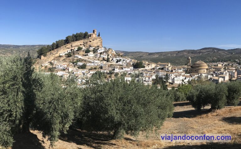
Trakai es una ciudad histórica situada a 28 km de Vilnius con una población de apenas 6.000 habitantes. Destaca por sus más de 200 lagos y por su imponente castillo medieval, que es lo que vinimos a visitar.
Nos bajamos en la estación de bus aún con el susto en el cuerpo debido a la terrible conducción del chofer y nos encaminamos dando un paseo hacia el castillo.
De camino, con el tremendo calor que hacía y la sed que llevábamos, decidimos comprar algo fresco en una licorería. Las neveras con los refrescos clásicos estaban apagadas así que nos fuimos a los raros. Compré una lata con una pera dibujada que estaba bien fría. La abro y le meto un lingotazo de casi media lata (de medio litro). Resultó ser sidra. Estaba muy bueno pero con tremendo buchazo se me empezó a subir a la cabeza…
El Castillo de Trakai (Trakų salos pilis) se encuentra situado en una isla en el lago Galvė (Galvės ežeras) y se empezó a construir en el siglo XIV por el Duque de Trakai y Gran Duque de Lituania Kęstutis.
Sufrió importantes daños durante el ataque de los caballeros teutónicos en 1377. En 1409 se terminó la reconstrucción y ampliación del castillo, por orden de Vitautas “el Grande”, hijo de Kęstutis. Pocos años después se hizo la última ampliación, añadiéndole galerías de fuego, tres torres en las esquinas del castillo y ensanchándose el muro defensivo.
El gran duque Vitautas el Grande murió en el castillo sin ser coronado rey de Lituania en 1430. Para el siglo XVI con la pérdida de la función militar y la pérdida del papel de residencia, la importancia del Castillo de la Isla disminuyó y los Grandes Duques lo visitaron cada vez menos. En 1511 se convierte en prisión para nobles y en el siglo XVII, Trakai es saqueada e incendiada y el castillo es destruido.
En 1929 se inició una excavación en las ruinas del castillo y en 1951 se inicia su reconstrucción. Para el año 1962 se establece aquí el Museo de Historia de Trakai.
La entrada al castillo nos costó 14 Lt (4€) y es uno de los lugares imprescindibles que ver en Lituania. Es realmente espectacular. Como apunte, la entrada en 2022 cuesta 12€.
A la salida del castillo, contratamos un paseo en barco por el lago con diferentes vistas del castillo. Nos costó 10 Lt (2.90€) e incluía una bebida. En mi caso una cervecita (de medio litro). Las 11.30 de la mañana y ya llevo un litro de alcohol en el cuerpo…
Terminado el paseo, se hacía la hora de comer. Nos fuimos en busca de un restaurante muy famoso llamado Kybynlar. Es un restaurante de gastronomía Caraíta. El Caraísmo es una corriente religiosa del judaísmo y actualmente se encuentra una pequeña comunidad caraíta turca en Trakai, que llegaron en el siglo XIV cuando el Gran Duque Vytautas llegó a la península de Crimea y se trajo 383 familias caraítas a Lituania.
Comimos de maravilla y muy barato. De primero pedimos unas kibiniai, unas empanadas de cordero que estaban exquisitas y de las que encontrarás la receta aquí. De segundo una sopa Canach que estaba deliciosa.
Lo mejor llegó con el postre. Me pedí un café que tenía un pintón increible. Pues resultó que también tenía alcohol. Madre mía, en Trakai lleva alcohol hasta el agua.
Después de comer dimos un paseo por la ciudad mientras enfilábamos la estación de bus. Pasamos por algunos edificios reseñables, como la Trakų kenesa. Kenesa es el nombre con el que se conocen los templos de los caraítas lituanos. Sólo se conservan dos kenesas en Lituania, la de Trakai y la de Vilnius.
Trakų kenesa
Tomamos el bus de vuelta a las 17.35. Nos costó algo más caro, 6.80 Lt .
Encuentra las mejores actividades y tours en Trakai de la mano de Civitatis.
*Nos ayuda a mantener el blog
Ya en Vilnius nos fuimos directamente a visitar el muro defensivo del Bastión de Vilnius (Vilniaus gynybinės sienos bastėja).
El territorio de los castillos superior e inferior de Vilnius estaba bien fortificado desde tiempos antiguos. Cuando Vilnius comenzó a crecer en el siglo XV, el territorio de la ciudad se expandió y sus castillos no pudieron brindar suficiente protección a la gente del pueblo. Tanto una Rusia cada vez más centralizada como los constantes ataques tártaros presentaban amenazas tanto para Vilnius como para todo el Gran Ducado de Lituania.
En 1503, el Gran Duque Alejandro de Lituania satisfizo las solicitudes de los residentes de Vilnius de que se construyera un muro de defensa de piedra alrededor de la ciudad. Con el tiempo, muy probablemente a principios del siglo XVIII, una parte de la muralla también se convirtió en una estructura de defensa: un bastión que consiste en una torre, un espacio en forma de herradura para la artillería y un túnel que los conecta. Se cree que el edificio fue diseñado por el ingeniero militar Fryderyk Getkant.
Bastión de Vilnius y las Tres Cruces (muy) al fondo.
El bastión y la muralla de defensa de la ciudad sufrieron daños considerables a mediados del siglo XVII, durante la guerra con Moscú. Habiendo perdido su función de defensa, el bastión se deterioró: su territorio se convirtió en un basurero y se enterraron antiguas trincheras y mampostería.
El análisis exhaustivo de este sitio comenzó en 1965, y durante las siguientes dos décadas, el bastión fue desenterrado y reconstruido. Hoy, el Bastión de Vilnius es el único edificio patrimonial de este tipo en Lituania. El museo contiene la historia de la defensa de Lituania.
Desde aquí tenemos unas vistas fantásticas de la iglesia de Santa Ana y las Tres Cruces.
Desde aquí nos dirigimos a Užupis. Éste es un barrio del centro histórico de Vilnius declarado Patrimonio de la humanidad por la UNESCO. El barrio es famoso por la cantidad de artistas que lo han habitado y aún lo habitan, tanto que ha sido comparado con Montmartre por su atmósfera bohemia, las numerosas galerías de arte, los talleres de artistas y cafés populares.
En 1998, los residentes del área declararon la República de Užupis (Užupio Res Publika), con su propia bandera, moneda, presidente, constitución, y ejército (con la friolera de 17 miembros).
Anualmente se celebra la independencia en el Día de Užupis, el 1°de Abril. El actual Presidente de la República de Užupis, Romas Lileikis, es poeta, músico y director de cine; y el antiguo alcalde de Vilnius, Artūras Zuokas, vive en Užupis siendo un participante activo en los eventos relacionados con la República.
Están una mijilla colgados los lituanos…
Paseamos por el barrio, con pocos elementos reseñables aunque es un barrio bastante chulo para contemplarlo paseando. Quizá lo más destacado es Užupio angelas, el Ángel de Užupis, la estatua de un ángel tocando la trompeta instalada el 1 de abril (día de la independencia) de 2002 en memoria del animador y caricaturista Zenonas Šteinys. Se convirtió en un símbolo del renacimiento Užupis. Los fondos se recaudaron vendiendo copias en miniatura de la escultura.
Anteriormente se había colocado temporalmente una escultura de un huevo que fue objeto de muchas anécdotas. Después de sustituirse por una escultura más grande, el huevo se vendió en una subasta por 10.200 Lt (aproximadamente 3.000€).
Damos un largo paseo por el barrio hasta el Cementerio Bernardino (Bernardinų kapinės), uno de los tres cementerios más antiguos de Vilnius. Cuenta con unos 38.000 m² y unos 14.000 enterramientos entre los que se encuentran los de numerosos ilustres lituanos.
Fue establecido en 1810 por los monjes Bernardinos de la Iglesia de San Francisco de Asís y su desarrollo fue consecuencia de que las autoridades zaristas del Imperio Ruso prohibieran enterrar a los muertos cerca de las iglesias. Los habitantes de Vilnius trasladaron el cementerio a lo que entonces eran las afueras de la ciudad.
Por desgracia llegamos tarde y ya estaba cerrado.
Volviendo sobre nuestros pasos, junto al puente de acceso a Užupis, encontramos la Catedral Ortodoxa de la Theokos (Vilniaus Dievo Motinos Ėmimo į Dangų katedra), la sede episcopal del Metropolitano Cristiano Ortodoxo Oriental de Vilnius y toda Lituania.
La catedral fue construida durante el reinado del Gran Duque de Lituania Algirdas para su segunda esposa ortodoxa Uliana de Tver en 1346. Es una de las más antiguas de Vilnius, construida antes de la cristianización de Lituania cuando el Gran Ducado de Lituania era el último estado pagano de Europa.
En 1495 se celebró en la catedral el matrimonio entre el Gran Duque Aleksandras de Lituania y Elena de Moscú, hija de Iván III, en presencia de San Macario. Fue allí donde Helena fue enterrada en 1513.
La catedral fue abandonada después de un gran incendio en 1748 y el edificio se utilizó para otros fines. Fue reconstruida en estilo barroco en 1785. La catedral fue nuevamente destruida por el ejército ruso durante el Levantamiento de Kościuszko.
En 1808, un prelado local vendió el edificio abandonado a la Universidad de Vilnius, tras lo que fue reconstruido completamente en 1822 en estilo neoclásico por el arquitecto polaco Karol Podczaszyński, también profesor de la Universidad de Vilnius. El edificio albergó un teatro anatómico, una biblioteca y otras instalaciones universitarias durante medio siglo.
La antigua catedral fue confiscada y transferida a la Iglesia Ortodoxa Rusa por iniciativa del conde Mikhail Nikolayevich Muravyov y su hermano durante la campaña de rusificación. El arquitecto ruso Nikolai Chagin fue el responsable de su reconstrucción desde 1865 hasta 1868 en un estilo que imitaba la arquitectura georgiana medieval.
La catedral sufrió severos daños durante la Seguna Guerra mundial y fue nuevamente restaurada entre 1948 y 1957.
Aquí damos por finalizada la primera parte del viaje. Al día siguiente por la mañana trasladamos el campamento a Klaipėda, en la costa del mar Báltico.
Para ofrecer las mejores experiencias, utilizamos tecnologías como las cookies para almacenar y/o acceder a la información del dispositivo. El consentimiento de estas tecnologías nos permitirá procesar datos como el comportamiento de navegación o las identificaciones únicas en este sitio. No consentir o retirar el consentimiento, puede afectar negativamente a ciertas características y funciones.
Funcional
Siempre activo
El almacenamiento o acceso técnico es estrictamente necesario para el propósito legítimo de permitir el uso de un servicio específico explícitamente solicitado por el abonado o usuario, o con el único propósito de llevar a cabo la transmisión de una comunicación a través de una red de comunicaciones electrónicas.
Preferencias
El almacenamiento o acceso técnico es necesario para la finalidad legítima de almacenar preferencias no solicitadas por el abonado o usuario.
Estadísticas
El almacenamiento o acceso técnico que es utilizado exclusivamente con fines estadísticos.El almacenamiento o acceso técnico que se utiliza exclusivamente con fines estadísticos anónimos. Sin un requerimiento, el cumplimiento voluntario por parte de tu Proveedor de servicios de Internet, o los registros adicionales de un tercero, la información almacenada o recuperada sólo para este propósito no se puede utilizar para identificarte.
Marketing
El almacenamiento o acceso técnico es necesario para crear perfiles de usuario para enviar publicidad, o para rastrear al usuario en una web o en varias web con fines de marketing similares.